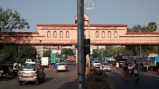
Currey Road Bridge, officially known as Mahadev Palav Marg, is a stone bridge built in 1915 [1] that connects the neighbourhoods of Parel and Lower Parel in Mumbai, India. [2] The road and bridge see heavy commuter traffic, as they connect Lalbaug and Parel with NM Joshi Marg. [3]
Three sections of the bridge wall had to be removed by the Mumbai Metropolitan Region Development Authority (MMRDA) in 2014 to make room construction of pillars for Line 1 of the Mumbai Monorail. [1]
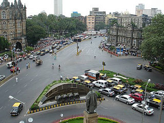
Transport in Mumbai is achieved by both public and private transport. As of 2016, 52% of commuters use public transport. Mumbai has the largest organized bus transport network among major Indian cities.
Chembur is an upmarket large suburb in central Mumbai, India. It belongs on the harbour line of suburban railways and offers the best connectivity with Mumbai Monorail, Santacruz- Chembur Link Road, Airport, Jeejamata Bhosle Marg, Eastern Freeway, Eastern Express Highway, BKC connector, and Mumbai Satara highway (Sion-Panvel).

Kurla is a suburb of East Mumbai, India. It is the headquarters of the Kurla taluka of Mumbai Suburban district. The neighbourhood is named after the eponymous East Indian village that it grew out of. It falls under Zone 5, Ward 'L' of the Bombay Municipal Corporation. Its railway station, spelt as Coorla until 1890, is one of the busiest on the Mumbai suburban railway on the central and harbour railway lines of Mumbai as is the Lokmanya Tilak Terminus (LTT) for out-station passenger/express trains.

Prabhadevi railway station is a Railway station junction which connects the Central line to Parel of Mumbai Suburban Railway. It serves the area of Prabhadevi in Mumbai, India. This railway station has two platforms which are of only slow trains halt.

Currey Road is a railway station that serves the Lower Parel neighbourhood in Mumbai. It is on the Central line of the Mumbai Suburban Railway serving the areas of Lalbaug and Parel.
The Western Freeway was a proposed controlled-access highway in Mumbai, India that would stretch from Marine Drive in South Mumbai to Kandivli in the north, a distance of 29 km. The project envisioned the construction of four major sea links over the Arabian Sea along Mumbai's western coastline to reduce traffic-congestion between the Western Suburbs and South Mumbai.

The Western Express Highway, abbreviated to WEH, is a major north–south 8-10 lane arterial road in Mumbai, India, stretching from the suburb of Mira Road to Bandra. The 25.33 km (15.74 mi) highway begins near the Mahim Creek and extends to the Kashimira in the northern limit of the city till it connects National Highway 48 at Ghodbunder village. The road connects the city of Mumbai to its suburbs, including the Chhatrapati Shivaji Maharaj International Airport.

The Santa Cruz–Chembur Link Road, shortened to SCLR, is a 6.45-kilometre-long (4.01 mi) arterial road in Mumbai, connecting the Western Express Highway (WEH) in Santa Cruz with the Eastern Express Highway (EEH) in Chembur. It contains the city's first and India's second double-decker flyover. The six-lane road was constructed as part of the World Bank-funded Mumbai Urban Transport Project (MUTP) at a cost of ₹454 crore (US$54 million). The World Bank withdrew funding midway through the project due to repeated delays, and the second phase was financed by the Mumbai Metropolitan Region Development Authority (MMRDA) with its own funds.
Lalbaug or is a neighbourhood in South Mumbai in Mumbai, the capital of Maharashtra an Indian state. It was once part of the neighbourhood called Girangaon, Mumbai's mill district that is now undergoing gentrification due to the shifting of textiles mills to Gujarat. Its railway stations include Currey Road station of Central Railway, Lower Parel station of Western Railway and the new Lower Parel station of the Mumbai Monorail.
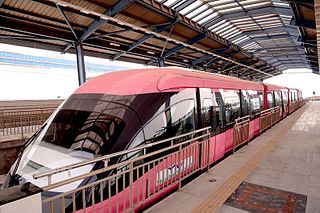
The MMRDA Mumbai Monorail is a monorail line in the city of Mumbai, Maharashtra, India, built as part of a major expansion of public transport in the city. The project is operated by the Mumbai Metropolitan Region Development Authority (MMRDA).

The Mumbai Trans Harbour Link, officially named as Atal Bihari Vajpayee Sewri–Nhava Sheva Atal Setu and colloquially known as Atal Setu, is a 21.8 km (13.5 mi) 6-lane grade separated expressway bridge, which connects Mumbai with Navi Mumbai, its satellite city. It is the longest sea bridge in India, and the world's 12th longest sea bridge. The bridge begins in Sewri, South Mumbai, crosses Thane Creek north of Elephanta Island, and terminates at Chirle near Nhava Sheva in Uran taluka, Navi Mumbai. The road is linked to the Mumbai–Pune Expressway in the east and to the Coastal Road in the west. The 6-lane highway is 27 meters in width, in addition to two emergency exit lanes, two edge strips, parallel crash barriers and noise barriers on both sides. The project costs a total of ₹17,843 crore (US$2.1 billion). The bridge has a capacity to handle 70,000 vehicles per day. Construction on the bridge began in April 2018, and was inaugurated by Prime Minister Narendra Modi on 12 January 2024.
The Sion Panvel Expressway is a 25 km Indian highway located entirely in the state of Maharashtra, that connects Sion in Mumbai with Panvel, via Navi Mumbai. It is one of the busiest and most important roads in the Mumbai Metropolitan Region (MMR) and connects Mumbai with the city of Pune. The National Highway 4 and Mumbai-Pune Expressway begin at the eastern end of the expressway, at Kalamboli junction, near Panvel. The highway is also used by vehicles traveling towards Mumbai from Konkan and Goa.
The Eastern Freeway, is a controlled-access highway, in Mumbai, that connects P D'Mello Road in South Mumbai to the Eastern Express Highway (EEH) at Chembur. It is 16.8 km (10.4 mi) long and its estimated cost is ₹1,436 crore (US$170 million). The Eastern Freeway was built by the Mumbai Metropolitan Region Development Authority (MMRDA) and funded by the Central Government through the Jawaharlal Nehru National Urban Renewal Mission (JnNURM). Construction was contracted to Simplex Infrastructure Ltd. A 13.59 km stretch of the freeway, comprising two of three segments with one of the twin tunnels, from Orange Gate on P D'Mello Road up to Panjarpol, near RK Studios in Chembur, was opened to the public on 14 June 2013. The second tunnel was opened on 12 April 2014. The third and final segment from Panjarpol to Jeejabai Bhosle Marg at Chembur was opened on 16 June 2014.

Lower Parel railway station is a railway station on the Western Line of the Mumbai Suburban Railway, India. The next station south is Mahalaxmi railway station; the next station north is Prabhadevi.

Parel is a railway station on the Central Line of the Mumbai Suburban Railway, serving the Parel neighbourhood of Mumbai. The next station south is Currey Road; the next station north is Dadar. A footbridge links Parel on the Central Line to Prabhadevi on Western Line.

Dadar railway station is one of the major interchange railway stations of Mumbai Suburban Railway. It serves the Dadar area in Mumbai, India.
Lal Bahadur Shastri Marg, commonly known by its abbreviation LBS Marg, is a 21 km long, major arterial road connecting the neighbouring city of Thane with Sion in Mumbai. It passes through heavily populated areas of the Eastern Suburbs in Mumbai and is heavily congested. Approximately, 3 lakh vehicles use this road daily. The road is named after Lal Bahadur Shastri, the second Prime Minister of India.
Mysore Colony is a monorail station of the Mumbai Monorail serving the only passenger Rail connectivity to Mahul region of Eastern Mumbai.
Mint Colony is a monorail station on Line 1 of the Mumbai Monorail located at Wadia Baug, Best Colony in the Parel suburb of Mumbai, India. Lies on the Shri Sai Baba Marg which is nearby Lalbaug Flyover.
Lower Parel is a monorail station of Mumbai Monorail located in the Lower Parel suburb of Mumbai, India. Lies on the NM Joshi Marg. It lies to the West of Lalbaug area of South Central Mumbai.
| | This article about a bridge in India is a stub. You can help Wikipedia by expanding it. |