
Chandrapur district is a district in the Nagpur Division in the Indian state of Maharashtra. Chandrapur was the largest district in India until the Gadchiroli and Sironcha tehsils were separated as Gadchiroli district in 1981. In 2011, the district population was 2,204,307.

Bhandara District is an administrative district in the state of Maharashtra in India. The district headquarters are located at Bhandara. The district occupies an area of 3717 km2 and has a population of 1,200,334, of which 19.48% are urban as of 2011. The growth rate of Bhandara is 5.56% Bhandara has a mixed economy with agriculture, industries and forest resources. Bhandara is known for its large production of rice. Tumsar, a tahsil town, is a noted rice market. Bhandara town is also known as "Brass City" owing to the presence of a large brass products industry. Bhandara has several tourist destinations, like Ambagad Fort, Brahmi, Chinchgad, and Dighori.

Gondia district is an administrative district in the state of Maharashtra in India. The district headquarter is located at Gondia. The district occupies an area of 5,234 km2 (2,021 sq mi) and has a population of 1,322,507 of which 11.95% were urban. The district is part of Nagpur Division. There are 8 Talukas in Gondia District. Gondia Airport is second airport in Vidharbha region and serves city of Gondia.

Nagpur district is a district in the Vidarbha region of Maharashtra state in central India. The city of Nagpur is the district administrative centre. The district is part of Nagpur Division.
Kannad is a Taluka and a Municipal Council City in Aurangabad District in the Indian state of Maharashtra. Kannad has located 58 km from Aurangabad. It is located 24 km away from the Ellora Caves and Grishneshwar Temple. It is 45 Km from Daulatabad / Deogiri Fort.
Ralegaon is Tehsil place town in Yavatmal District of Maharashtra (India). It is located in Vidarbha region of Maharashra. Geographically it is located northwest from Yavatmal. It is located 42 km away from Yavatmal and 21 km away from the Kalamb which is on Nagpur-Yavatmal road. And just 41 km from city Wardha.
Arvi is a city and municipal council in Wardha district in the state of Maharashtra, India.
Naigaon is a town and taluka in Nanded district of Maharashtra state in India. Naigaon (Bz.) is located 41.2 km south of the district headquarters city of Nanded and 60 km west from neighboring city of Nizamabad in Telangana State. Naigaon lies on MSH - 6. It is approximately 600 km from the State capital Mumbai. It is the Center of Naigaon Taluka. Naigaon is one of the rapidly growing towns in the Nanded District. The economy is primarily based on agriculture and related business.

Rahata taluka, is a taluka in Shrirampur subdivision of Ahmednagar district in Maharashtra State of India.

Bhor taluka is a taluka in Haveli subdivision of Pune district of state of Maharashtra in India. There are 195 villages and 1 town in Bhor Taluka.

Taluka Haveli is a subdivision of the district of Pune, Maharashtra. The Pune Municipal Corporation & Pimpri Chinchwad Municipal Corporation, Pune are at the center of & entirely surrounded by the taluka for administrative purposes. The region of Pune Metropolitan Region has claimed the major part of the same.

Indapur taluka is a taluka in Baramati subdivision of Pune district of state of Maharashtra in India.

Khed taluka is a taluka in the subdivision, near Pune city in Pune district of the state of Maharashtra in India. Rajgurunagar is the headquarter of the taluka. The taluka is known for being the birthplace of Santaji Jagnade.The name of city is rajgurunagar on the name of Shaheed Shivram Hari Rajguru.
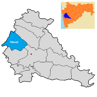
Maval taluka is a taluka in Mawal subdivision of Pune district of state of Maharashtra in India.

Purandar taluka is a taluka of Pune district of state of Maharashtra in India. There are 108 villages and 3 towns in Purandhar Taluka.

Shirur taluka, is a taluka in Haveli subdivision of Pune district of state of Maharashtra in India. The town is situated on the bank of river Ghod and hence it was also known as Ghodnadi in 20th Century. The town is on the border of Pune & Ahmed Nagar District and hence, main trading center for Shirur Taluka as well as Parner Taluka located in Ahmed Nagar District.
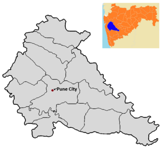
Pune City taluka is the main taluka in the Pune district of state of Maharashtra in India.

Velhe Taluka, officially renamed as, Rajgad Taluka, is a taluka in Haveli subdivision of Pune district of state of Maharashtra in India. The Taluka is entirely rural, and consists of 130 villages.

The Pench River is an Indian tributary of the Kanhan River. It originates in the Chhindwara district of Madhya Pradesh and flows across Pench National Park, which is a reserve for the Tiger Project of India.
The Sur is a river in India. It is a key tributary of the Wainganga. The river flows south in a winding course through the Vidarbha region of Maharashtra.
