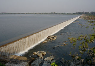
The Godavari is India's second longest river after the Ganga. Its source is in Triambakeshwar, Maharashtra. It flows east for 1,465 kilometres (910 mi), draining the states of Maharashtra (48.6%), Telangana (18.8%), Andhra Pradesh (4.5%), Chhattisgarh (10.9%), Odisha (5.7%),ultimately emptying into the Bay of Bengal through its extensive network of tributaries. Measuring up to 312,812 km2 (120,777 sq mi), it forms one of the largest river basins in the Indian subcontinent, with only the Ganga and Indus rivers having a larger drainage basin. In terms of length, catchment area and discharge, the Godavari is the largest in peninsular India, and had been dubbed as the Vridha Ganga.

Nashik is an ancient holy city in the northern region of the Indian state of Maharashtra. Situated on the banks of river Godavari, Nasik is well known for being one of the Hindu pilgrimage sites, that of Kumbh Mela which is held every 12 years.
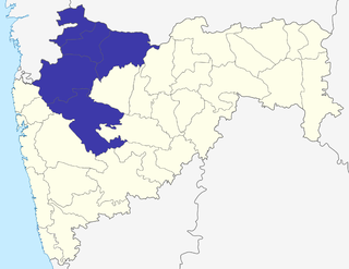
Nashik division is one of the six divisions of India's Maharashtra state and is also known as North Maharashtra. The historic Khandesh region covers the northern part of the division, in the valley of the Tapti River. Nashik Division is bound by Konkan Division and the state of Gujarat to the west, Madhya Pradesh state to the north, Amravati Division and Marathwada to the east, and Pune Division to the south. The city of Nashik is the largest city of this division.

Nashik district, also known as Nasik district, is a district in Maharashtra, India. The city of Nashik is the administrative headquarters of the district. Nashik is well known for the production of wine. Nashik is also known as Mini Maharashtra, because the climate and soil conditions of Surgana, Peth, Igatpuri resembles with Konkan. Niphad, Sinnar, Dindori, Baglan blocks are like Western Maharashtra and Yeola, Nandgaon, Chandwad blocks are like Vidarbha Region. Nashik, Malegaon, Manmad, Igatpuri are some of the big cities situated in the Nashik District.

Deolali, or Devlali, is a small hill station and a census town in Nashik district of the Indian state of Maharashtra.

Chandwad (IPA:Cāndavaḍa) is a town located in the Nashik district in Maharashtra. It is 250 km away from Mumbai. There are many historical places like 11th century Jain Caves, Renuka devi mandir, Chandreshwar temple and Rangmahal located in Chandwad.
Nashik Lok Sabha constituency is one of the 48 Lok Sabha (parliamentary) constituencies of Maharashtra state in western India.

Gandhinagar Airport was a public airport serving the city of Nashik, in the state of Maharashtra, India until when it was taken over by the Indian Army to convert the airport into a Military Airbase.
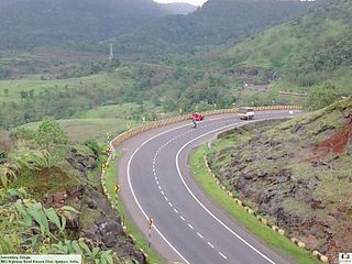
Mumbai Nashik Expressway is a 150 km (93 mi) long highway connecting Mumbai to Nashik. The total cost of the project is ₹40 billion (US$560 million). At the time when this project was awarded, it was the largest BOT road project in India. The project involves increasing the number of lanes on the 99.5 km Vadape-Gonde (Mumbai-Nasik) section of the National Highway-3 to four.
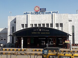
Nasik Road railway station serves Nashik city, Nashik Road and surrounding areas in Nashik district in the Indian state of Maharashtra.It is main railway station of Nashik.It is one of the busiest railway station in India.It is Located On Mumbai-Delhi, Mumbai-Kolkata Main line.It is A1 category Railway station.It comes under Bhusawal Division Of Central Railway.Near about 300 Trains are having halt on this railway station.Approxiamately 2,00,000 pepole travel daily from this railway station.It is one of the cleanest railway station in India.
The Greater Nashik Metro or Metro NEO is a proposed rapid transit system in the Nashik metropolitan area. The system is proposed to reduce traffic congestion as well as provide direct connectivity to Nashik city from its Suburbs. The Greater Nashik Metro will connect suburbs of Nashik city like Deolali, Nashik Road, Upnagar, Nashik Airport, Sinnar, Igatpuri, Gangapur, Traimbakeshwar, Dindori, Bhagur, Niphad, Adagaon, Ghoti and Girnare.
RattanIndia Nashik Thermal Power Project is a coal-based thermal power plant located in Sinnar in Nashik district Maharashtra. The power plant is operated by the RattanIndia Power Limited.

Trimbakeshwar Range is a mountain range in the Western Ghats of Maharashtra entirely situated in Nashik District. The range lies 30 km southwest to the district headquarters Nashik. The saddle shaped depression of the Brahmagiri mountain protects Trimbak, a town considered holy by Hindus Devotees throng to this town to pay visit to the sacred Trimbakeshwar Shiva Temple. The northern face of the range is the birthplace of India's 2nd longest river Godavari.The southern face of these hills are covered with dense forests and thus form a catchment area for the Upper Vaitarna Reservoir, the most important and reliable source of potable water supply to the metropolitan city of Mumbai. Trimbakeshwar range also contain the Anjaneri hills though a minority of authors consider the latter to be a distinct range and often prefer to use the synonym Trimbak-Anjaneri to avoid disambiguation.
Darna is a minor right-bank tributary of Godavari in the Nashik District, Maharashtra. Rising north of the Kalsubai range, it drains Igatpuri, Nashik and Niphad Talukas of Nashik District. The conjunction with Godavari is situated at Darnasangvi.
Nasardi is an insignificant tributary of the river Godavari which runs its course through the city of Nashik, Maharashtra.
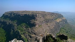
Tankai fort is a hill, part of the Satmala Range, with the ruins of a large Maratha hill fort on the peak. With Ankai Fort near this fort are known as Ankai-Tankai, the strongest hill fort in the Nashik district, rises about 900 feet above the plain and 3200 feet above the sea. It is located from Manmad in Yeola taluka of Nashik district in Maharashtra, India.

Tringalwadi fort is located in the Igatpuri taluka of Nashik district. It is located on the ancient trade route passing through Thal ghat. The fort is located near village Tringalwadi. The Tringalwadi irrigation dam which is close to the village was built in 1978

Harihar fort / Harshagad is a fort located 40km from Nashik City, 48 km from Igatpuri, 40 km from Ghoti in Nashik district, of Maharashtra. It is an important fort in Nashik district, and was constructed to look upon the trade route through Gonda Ghat. It receives many visitors because of its peculiar rock-cut steps.
Ahivant Fort / अहिवंत किल्ला is a fort located 55km from Nashik,in Nashik district, of Maharashtra. This fort is an important fort in Nashik district. The three forts Achala, Ahivant, and Mohandar are very close by. The other two forts were constructed to guard the Ahivant fort. Captain Briggs has described it as a large and shapeless hill, remarkably bleak and unhealthy.
