
Prataprao Gujar was a Maratha general who served as the 3rd Senapati of the Maratha Empire during the reign of Chhatrapati Shivaji. He commanded the Maratha army until 1674.
Moropant Trimbak Pingale'

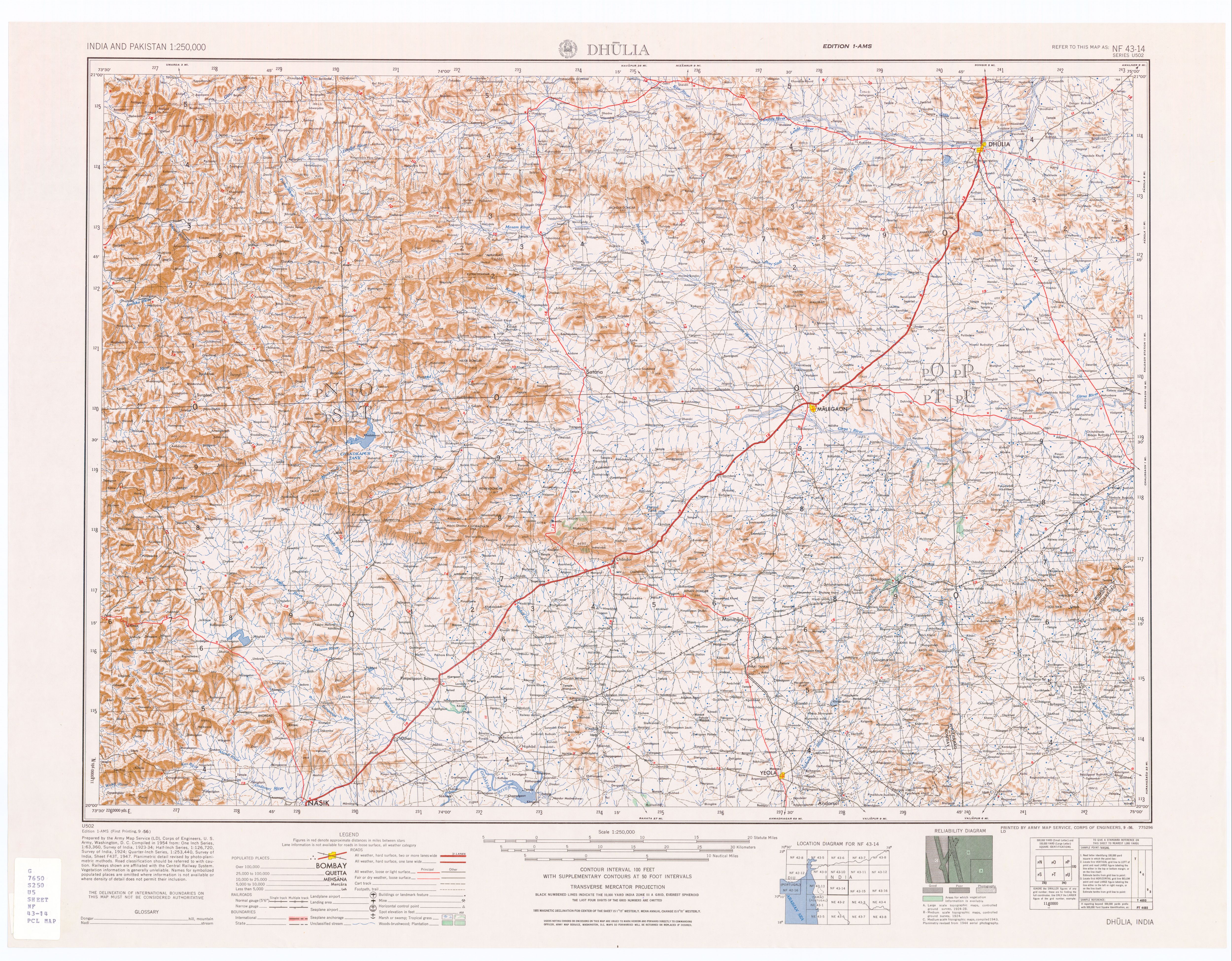
Nashik district, formerly known as Nasik district, is a district in Maharashtra, India. The city of Nashik is the administrative headquarters of the district. Nashik is well known for the production of wine. Nashik is also known as Mini Maharashtra, because the climate and soil conditions of Surgana, Peth, Igatpuri resembles with Konkan. Niphad, Sinnar, Dindori, Baglan blocks are like Western Maharashtra and Yeola, Nandgaon, Chandwad blocks are like Vidarbha Region. Nashik is the biggest city in the district while Malegaon is the second biggest city. Manmad, Igatpuri, and Sinnar are some of the big cities situated in the Nashik District. Manmad is one of the biggest railway junctions in India while the city of Malegaon is famous for its powerloom.
Salher is a place located near Salher Village in Satana tehsil in Nashik district of Maharashtra, India.The old name of Salher was Gavalgarh. It is the site of the highest fort in the Sahyadri mountains and the second highest peak at 1,567 metres (5,141 ft) after Kalsubai in Maharashtra and 32nd highest peak in Western Ghats. This was a fort of the Maratha Empire. The money acquired after raiding Surat was brought to this fort first on its way to the Maratha capital forts.
Chakan is a city and municipal council in Pune district of the Indian state of Maharashtra. The Chakan is also part of Pune Metropolitan Region Development Authority. Chakan is one of the largest automobile and manufacturing hub of India. Being developed as a hub for manufacturing and logistics by MIDC, Chakan is home to some of the biggest names in automobile manufacturing: Volkswagen, Bajaj Auto, Mercedes Benz, Hyundai, and more. Chakan is often referred to as the "Automobile Hub of India". The Independent referred Chakan as India's "Motor City". The city is about 30 km from the city of Pune and 140km from Mumbai.

Rajgad is a Hill region fort situated in the Pune district of Maharashtra, India. Formerly known as Murumbdev, the fort was the first capital of the Maratha Empire under the rule of Chhatrapati Shivaji for almost 26 years, after which the capital was moved to the Raigad Fort. Treasures discovered from an adjacent fort called Torna were used to completely build and fortify the Rajgad Fort.

Baglan is a taluka (tehsil) in Nashik District in the Indian state of Maharashtra. Sometimes Baglan Taluka is unofficially referred to as Satana, because of that city's dominance within the taluka.
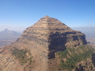
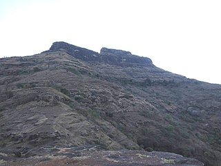
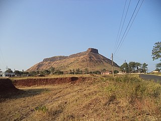
Dhodap is one of the hill forts in Maharashtra state in India. Situated in Chandwad taluka in the Nashik district. the fort is 4829 ft above sea level. It is the site of the second-highest fort in the Sahyadri mountains after Salher. Dhodap hill is the second-highest hill peak in Maharashtra after Kalsubai and Salher and the 29th highest peak in Western Ghats.
Nampur is a village in Nashik District of Maharashtra, India. As per census of 2011 by Govt of India It is situated near Satana also called as Baglan Taluka, the headquarters for Baglan Taluka, at the distance of 21 km (13 mi). Nampur is known in the states of Maharashtra, Karnataka and Gujarat for its cattle market. It is near to Gujarat and is a major transportation hub. It is 35 kilometres (22 mi) from the city of Malegaon and 25 kilometres (16 mi) from Taharabad on the road (SH-16) to Gujarat. The first MLA elected from Baglan Taluka was from Tembhe which is just 7 km (4.3 mi) from Nampur.
The Battle of Salher was fought between the Marathas and the Mughal Empire in February 1672 CE. The battle was fought near the fort of Salher in modern-day Nashik district. The result was a decisive victory for the Marathas. This battle is considered particularly significant as it is the first pitched battle where the Mughal Empire lost to the Marathas.

Mora fort is located in the Baglan area of Nashik district. There are two main hill ranges in Baglan area, the Selbari range is south of the Dolbari hill range. These two ranges run parallel to each other in east-west direction. Moragad is located on Selbari hill range. All these forts were maintained to keep watch on the Burhanpur-Surat ancient commercial road. The road passes between the two hill ranges. Mora fort is a small fort, east of Mulher fort.
Achala Fort is a westernmost fort in the Satmala hill range. It is located 55 km from Nashik, in Nashik district, of Maharashtra. This fort is adjoining the Ahivant Fort. The three forts Achala, Ahivant, and Mohandar are very close by. The Achala and Mohandar forts were constructed to guard the Ahivant fort. Captain Briggs has described it as a large hill, whose ascent is very easy till it reaches the top where it is very steep.

Malegaon Fort is a land fort located in the town of Malegaon. It is located 104 km from Nashik, in Nashik district, of Maharashtra. The fort is on the north bank of the Mausam river, which is a tributary of the Girna river. It was built during the Maratha Empire.

Hargad Fort is located in the Baglan area of Nashik district. There are two main hill ranges in Baglan area, the Selbari range is south of the Dolbari hill range. These two ranges run parallel to each other in east-west direction. Hargad is located on Selbari hill range. All these forts were maintained to keep watch on the Burhanpur-Surat ancient commercial road. The road passes between the two hill ranges. Hargad fort is a small fort, close to Mulher fort. These are key forts situated between fertile lands of Khandesh and port city of Surat.
Javlya Fort is located 43 km from Nashik, Nashik district, of Maharashtra. Ravlya fort and Javlya fort are twin forts located on a single hill plateau, Ravlya on the west and Javlya on the east side of the hill plateau.
Ravalya Fort is located 43 km from Nashik, Nashik district, of Maharashtra. The Ravlya fort and Javlya fort are twin forts located on a single hill plateau. Ravlya on the west and the Javlya on the east side of the hill plateau.
Chauler Fort is a small fort located 100 kilometres (62 mi) north of Nashik, in the Indian state of Maharashtra. This fort can be visited in a day from Nashik. The nearest town is Satana.
Siege of Ramsej was a series of military confrontations between the Maratha Empire headed by Sambhaji and the Mughal Empire led by Aurangzeb regarding the control of Ramsej Fort in the Nashik region. Aurangzeb arrived in the Deccan in late 1681 with a strong army to destroy the Maratha Empire and the Deccan Sultanates of Adilshahi and Qutubshahi. He wanted to capture the forts held by the Marathas in the Nashik and Baglana regions. Hence he decided to begin his Deccan campaign with an attack on Ramsej Fort which is near Nashik. The Mughal forces under Kasim Khan Kirmani captured Ramsej from the Marathas. The defending Maratha forces evacuated the fort.
Markandya Fort/Markinda Fort/ Markanda fort is a fort located 52 km (32 mi)from Nashik, Nashik district, of Maharashtra. The base village is Mulane on the Wani-Kalwan Link Road. The nearest town is Wani, which is 5.5 km from Mulane village. This fort is opposite the holy Saptashringi hill..

Bahadur Khan Kokaltash was a foster-brother to the Mughal Emperor Aurangzeb and the Subahdar of Lahore, Burhanpur and the Deccan. Aurangzeb had two foster-brothers, the other being Fidai Khan Koka, of which Bahadur Khan was Aurangzeb's favourite. Bahadur was the Senior General of the Mughal Empire and a closer companion to the emperor Aurangzeb. He was one of the military commanders of the Mughals who assisted in the deafeat of the Maratha Confederacy in three major battles, and lost one in his involvement in the Mughal–Maratha Wars. He was buried in his tomb, located in present-day Pakistan. His father Mir Abu’l-Ma'ali was given the title of Sayyid-e Khafi" by Aurangzeb. Through his son Shah Quli Khan, he had a grandson Alivardi Khan, the Nawab of Bengal.


