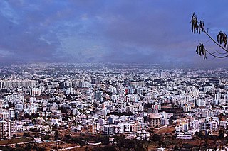
Nashik, Marathi: [naːʃik], formerly Nasik) is a city in the northern region of the Indian state of Maharashtra. Situated on the banks of the river Godavari, Nashik is the sixth largest city in Maharashtra after Pimpri-Chinchwad. The population of Nashik city is around 22 lakhs and is emerging as one of the fastest-growing cities in India. Nashik is located about 165 km northeast of the state capital Mumbai, and about 210 km north from Pune. The Mumbai-Pune-Nashik region is called the "Golden Triangle of Maharashtra". With its high agricultural production, Nashik is dubbed the Napa Valley of India and the "Wine Capital of India" as more than half of India's vineyards and wineries are located here. Around 90% of all Indian wine comes from the Nashik Valley. Nashik is well known for being one of the Hindu pilgrimage sites of the Kumbh Mela, which is held every 12 years.It has been a major industrial center in automobile hub. The city houses companies like Exxelia, Atlas Copco, Robert Bosch GmbH, CEAT Limited, Crompton Greaves, Graphite India, ThyssenKrupp, Epcos, Everest Industries, Gabriel India, GlaxoSmithKline, Hindustan Coca-Cola, Hindustan Unilever Limited, Jindal Polyster, Jyoti Structures, Kirloskar Oil Engines, KSB Pumps, Larsen & Toubro, Mahindra and Mahindra, Mahindra Sona, United Spirits Limited, Perfect Circle Industries, Mahindra Ugine Steel, Samsonite, Shalimar Paints, Siemens, VIP Industries, Indian Oil Corporation, XLO India Limited and Jindal Saw, among others.
Satara is a city located in the Satara District of Maharashtra state of India, near the confluence of the river Krishna and its tributary, the Venna. The city was established in the 16th century and was the seat of the Chhatrapati of Maratha Empire, Shahu I. It is the headquarters of Satara Tehsil, as well as the Satara District. The city gets its name from the seven forts (Sat-Tara) which are around the city. The city is known as a Soldier's city as well as Pensioner's city.

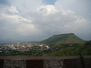
The Shri Trimbakeshwar Shiva Temple is an ancient Hindu temple in the town of Trimbak, in the Trimbakeshwar tehsil in the Nashik District of Maharashtra, India, 28 km from the city of Nashik and 40 km from Nashik road. It is dedicated to Hindu god Shiva and is one of the twelve jyotirlingas where the Hindu genealogy registers at Trimbakeshwar, Maharashtra are kept. The origin of the sacred Godavari river is near Trimbak.

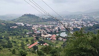
Nashik district, also known as Nasik district, is a district in Maharashtra, India. The city of Nashik is the administrative headquarters of the district. Nashik is well known for the production of wine. Nashik is also known as Mini Maharashtra, because the climate and soil conditions of Surgana, Peth, Igatpuri resembles with Konkan. Niphad, Sinnar, Dindori, Baglan blocks are like Western Maharashtra and Yeola, Nandgaon, Chandwad blocks are like Vidarbha Region. Nashik is the biggest city in the district while Malegaon is the second biggest city. Manmad, Igatpuri, and Sinnar are some of the big cities situated in the Nashik District. Manmad is one of the biggest railway junctions in India while the city of Malegaon is famous for its powerloom.

Niphad is the name both of the town and the Taluka headquartered there. It is within the Nashik District of Maharashtra, India. The Marathi name signifies "a place without mountains", and indeed the taluka's topography is fairly level, with hardly any hills. It is served by Niphad railway station. Niphad's latitude and longitude coordinates are 20°5′0″N74°7′0″E. Located northeast of Nashik city, the Taluka borders Sinnar, Nashik, Dindori, Chandwad, and Yeola Talukas and Ahmednagar District, and has no direct access to the sea. The Niphad Sub-Division is composed of Niphad, Sinnar and Yeola Talukas.
Trimbak is a city and a municipal council in Nashik District in the Indian state of Maharashtra. The Trimbakeshwar Shiva Temple is located here, one of the twelve Jyotirlingas, where the Hindu genealogy registers at Trimbakeshwar, Maharashtra are kept. The origin of the sacred Godavari river is near Trimbak.

Chandwad (IPA:Cāndavaḍa) is a town located in the Nashik district in Maharashtra. It is 250 km from Mumbai. The 11th-century Jain Caves, Renuka devi mandir, Chandreshwar temple and Rangmahal are in Chandwad.

The economy of the state of Maharashtra is the largest in India.

Maharashtra attracts tourists from other Indian states and foreign countries. It was the second most visited Indian state by foreigners and fifth most visited state by domestic tourists in the country in 2021. Aurangabad is the tourism capital of Maharashtra.
Nivruttinath was a 13th-century Marathi Bhakti saint, poet, philosopher and yogi of the Vaishnava Nath tradition. He was the elder brother and the mentor (guru) of Dnyaneshwar, the first Varkari saint.
Chinchpada is a panchayat village located in Nashik division of the Kandesh region of Maharashtra state in India. The village used to be called Bodhgaon. Administratively, Chinchpada is under Navapur Taluka, Nandurbar District, Maharashtra. There is only the single village of Chinchpada in the Chinchpada gram panchayat. It is located on National Highway 6, running from Hazira in Gujarat to Kolkota, West Bengal. It is about 100 km from Dhule and about 120 km from Surat.
Pimpalgaon Baswant is a town in Niphad Taluk, Nashik District, Maharashtra, India. It is located to the north of Kadva River, about 28 kilometres northeast of the district capital Nashik, and 16 kilometres northwest of the taluk capital Niphad. In the year 2011, it is home to 41,559 inhabitants.
Nampur is a village in Nashik District of Maharashtra, India. As per census of 2011 by Govt of India It is situated near Satana also called as Baglan Taluka, the headquarters for Baglan Taluka, at the distance of 21 km. Nampur is known in the states of Maharashtra, Karnataka and Gujarat for its cattle market. It is near to Gujarat and is a major transportation hub. It is 35 kilometers from the city of Malegaon and 25 from Taharabad on the road (SH-16) to Gujarat. The first MLA elected from Baglan Taluka was from Tembhe which is just 7 km from Nampur. In the 2001 census, the village of Nampur had 12,458 inhabitants, with 6,386 males (51.3%) and 6,072 females (48.7%), for a gender ratio of 951 females per thousand males
Satawali is a census town in Lanja-Taluka Ratnagiri district in the Indian state of Maharashtra.
Khadak Malegaon, Subdistrict-Niphad, District-Nashik, Maharashtra, India, 422304. The village is well known for production of quality grapes. Khadak Malegaon contributes a remarkable supply quantity of grapes every year to the country and abroad. Khadak Malegaon is situated on banks of river Shelu and on Niphad-Chandwad Connecting Road and shares border with Pimplad in East, Khangaon in South, Deorgaon in North-West, Sarole Kh. in South-West and Vanasgaon.

Palghar District is a district in the state of Maharashtra in Konkan Division. The headquarters of the district is the town of Palghar. Other major cities in the district are Vasai-Virar, Talasari, Jawhar and Dahanu.

The culture of the city of Nashik, in northwestern Maharashtra, is centred around Hindu customs and festivals.
Trymbakgad Fort/Brahmagiri Fort is a fort located 30 km from Nashik, in Nashik district, of Maharashtra, India. This is an important fort in Nashik district. It is located on a hill adjoining the famous Trimbakeshwar temple.
Mangdari is a village in Velhe Taluka in the Pune District of Maharashtra, India.
Chandol is a village located in Buldhana Tehsil of Buldhana district in Maharashtra, India.

