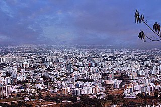
Nashik, Marathi: [naːʃik], formerly Nasik) is a city in the northern region of the Indian state of Maharashtra. Situated on the banks of the river Godavari. The population of Nashik city is around 2.2 million and is emerging as one of the fastest-growing cities in India. Nashik is located about 165 km (103 mi) northeast of the state capital Mumbai, and about 210 km (130 mi) north of Pune. The Mumbai-Pune-Nashik region is called the "Golden Triangle of Maharashtra". With its high agricultural production, Nashik is dubbed the Napa Valley of India and the "Wine Capital of India" as more than half of India's vineyards and wineries are located here. Around 90% of all Indian wine comes from the Nashik Valley. Nashik is one of the Hindu pilgrimage sites of the Kumbh Mela, which is held every 12 years.

Manmad ( [mənmaːɖ]) is a town in Nashik district in Maharashtra, India. It is the third largest city in Nashik district, with a population of approximately 80,000. Geographically, the town lies within Nandgaon Tehsil in Nashik District. Though it has a larger area and population than most Tehsils in the district, it does not have a Tehsil office.

Igatpuri is a town and a Hill Station. It is also a municipal council in Nashik District in the Indian state of Maharashtra. It is located in the Western Ghats. Igatpuri railway station lies in Nashik District, between Mumbai and Nashik Road on the Central Railway. Igatpuri is known for Vipassana International Academy, where ancient techniques of meditation is taught called Vipassana. The place is one of the best places to visit in Maharashtra in monsoon. It is a hill station on busy Mumbai-Agra NH-3 only 45 km from Nashik and 130 km from Mumbai.
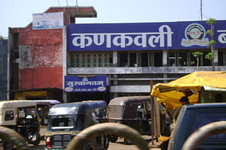
Kankavli is a city in Sindhudurg district in the Indian state of Maharashtra. It is in the center of the Sindhudurg district, between two rivers.
Deolali, or Devlali, is a small hill station and a census town in Nashik district of the Indian state of Maharashtra. Now it is part of Nashik Metropolitan Region.
Dyane is a census town in Nashik district in the state of Maharashtra, India.
Eklahare is a census town in Nashik district in the state of Maharashtra, India.
Kasara is a census town in Thane district in the Indian state of Maharashtra. The town is on the busy Mumbai–Nashik route, which is one of the four major routes that lead into Mumbai. Kasara is served by a railway station on the Mumbai Suburban Railway, and is the final stop in the north-east sector of the Central Line and important railway station. That is for abbreviation for Kasara Local is set as "N" means North side Local's Last Station. Town is also known for the winding Thal Ghat or better known as Kasara Ghats.
Kusgaon Budruk is a census town in Pune district in the Indian state of Maharashtra.
Lasalgaon is a census town in Nashik District in the Indian state of Maharashtra.
Manor is a census town in Palghar district in the Indian state of Maharashtra.
Nimbhore Budruk is a census town in Jalgaon district in the Indian state of Maharashtra.
Sinnar is a city and a municipal council in Sinnar taluka of Nashik district in the Indian state of Maharashtra. Sinnar is the third largest city in Nashik district after Nashik and Malegaon.
Soyagaon or soegaon is a Town and Taluka in Nashik District in the Indian state of Maharashtra.
Surgana is a census town and taluka in Nashik District in the Indian state of Maharashtra.
Chakan is a census town in India, in Pune district of the Indian state of Maharashtra. While agriculture remains an important factor, the town's industrial development is quickly urbanizing the area. The Independent referred Chakan as India's "Motor City".
Satana is a town and a municipal council in Nashik District in the Indian state of Maharashtra. It is in the taluka of Baglan, which is sometimes called Satana, because of the city's dominance in the taluka. The name "Satana" is derived from "Śāṭyāyani" one of the minor Upanishads of the Muktika canon.
Peth or Peint is the smallest tehsil of Nashik subdivision of Nashik district in Maharashtra, India. It belongs to Northern Maharashtra region. It belongs to Nashik Division. Peth is a Taluka headquarter. It is located 54 km to the West of Nashik District headquarters. It is also called as Peint. Pin code of Peth is 422208 and postal head office is Peth.
Vasind is a city in Shahapur taluka of Thane district in the Indian state of Maharashtra. It is suburban city of Mumbai.Mumbai-Vasind distance is about 63.1 km. Vashind is a census town.
Budruk is a suffix found in the place names of the former Maratha territory in India. It is similar to Kalan found in northern India, and is used to distinguish two segments of a village or two villages with the same name. "Khurd" means smaller, and "Budruk" means greater; both the words are of Persian origin.


