Vadgaon Malegaon

Last updated

Vadgaon
Village
India Maharashtra location map.svg
Red pog.svg
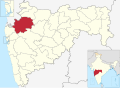
Vadgaon
Location in Maharashtra, India
Coordinates: 20°35′34″N74°31′17″E / 20.5927259°N 74.521366°E / 20.5927259; 74.521366 Coordinates: 20°35′34″N74°31′17″E / 20.5927259°N 74.521366°E / 20.5927259; 74.521366
CountryFlag of India.svg  India
State Maharashtra
District Nashik
Government
  TypeGram Panchayat
  SarpanchShrimati Varsha Ahire
Population
 (2011)
  Total4,112
Languages
  Official Ahirani
Time zone UTC+5:30 (IST)
Postal Index Number
423105
Vehicle registration MH 41

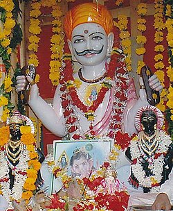
Vadgaon is a census town in Nashik district in the Indian state of Maharashtra. [1]

Contents

Geography

It is located 119 kilometres (74 mi) east from District headquarters Nashik. 4 kilometres (2.5 mi) from Malegaon. 289 kilometres (180 mi) from state capital Mumbai. Nilgawan (2 km), Camp (3 km), Dnyane (3 km), Osiya Nagar (5 km), Lendane (5 km) are the nearby villages.

Vadgaon is surrounded by Baglan Taluka towards west, Nandgaon Taluka towards South, Deola Taluka towards west, Chandwad Taluka towards south.

Malegaon, Satana, and Manmad are nearby cities. [2]

Vadgaon has a sub village Vaitagwadi, Dadawadi.

Demographics

As of 2011 India census, [3] Vadgaon had a population of 4,112. Males constitute 51.24% of the population and females 48.76%. Vadgaon has an average literacy rate of 75%, higher than the national average of 74.04%: Male literacy is 80%, and female literacy is 69%. In Vadgaon, 13% of the population is under 6 years of age.

Education

The education system supports Marathi and English learning. Two schools offer primary and secondary education. For higher education students go to Malegaon. The two schools in Vadgaon are ZP School and Mokshayani Vidyalaya.

Culture

saavtaa mhaaraaj muurtii saavtaa mhaaraaj.jpg
सावता महाराज मूर्ती

Well-known temples include Panch Mukhi Mahadev, Hanuman Mandir, Renuka Mata Mandir, and Savata Maharaj.

Related Research Articles

<span class="mw-page-title-main">Malegaon</span> City in Maharashtra, India

Malegaon is a city and a municipal corporation in Nashik District in the Indian state of Maharashtra. It is situated on the bank of Mosam River.

<span class="mw-page-title-main">Nashik district</span> District of Maharashtra in India

Nashik district, also known as Nasik district, is a district in Maharashtra, India. The city of Nashik is the administrative headquarters of the district. Nashik is well known for the production of wine. Nashik is also known as Mini Maharashtra, because the climate and soil conditions of Surgana, Peth, Igatpuri resembles with Konkan. Niphad, Sinnar, Dindori, Baglan blocks are like Western Maharashtra and Yeola, Nandgaon, Chandwad blocks are like Vidarbha Region. Nashik is the biggest city in the district while Malegaon is the second biggest city. Manmad, Igatpuri, sinnar are some of the big cities situated in the Nashik District. Manmad is one of the biggest railway junction in india while the city of Malegaon is famous for its powerloom.

<span class="mw-page-title-main">Niphad</span> Town in Nashik, India

Niphad is the name both of the town and the Taluka headquartered there. It is within the Nashik District of Maharashtra, India. The Marathi name signifies "a place without mountains", and indeed the taluka's topography is fairly level, with hardly any hills. It is served by Niphad railway station. Niphad's latitude and longitude coordinates are 20°5′0″N74°7′0″E. Located northeast of Nashik city, the Taluka borders Sinnar, Nashik, Dindori, Chandwad, and Yeola Talukas and Ahmednagar District, and has no direct access to the sea. The Niphad Sub-Division is composed of Niphad, Sinnar and Yeola Talukas.

Chikhli is a city and a municipal council in Buldana district in Vidarbha Region of Maharashtra state, India. It is located on the Pune-Nagpur highway. It is situated at the westernmost border of Vidarbha region of Maharashtra and is 500 km from the state capital, Mumbai. Chikhli has the largest population in buldhana district and is the biggest taluka. Chikhli is situated on the border of the Marathwada Region and Vidarbha Regions of Maharashtra. Chikhli is the nearest municipal council to the district place, Buldana, approximately 25 km only. Also in addition, there is a cotton factory in Chikhli which provides employment to many people who comes in this city for employment purpose. MIDC is located on Nagpur-Pune highway where many small scale, middle scale and some large scale firms of automotive, chemical, fibres and plastic, iron casting and other sectors are situated. Textile park was sanctioned near city and land acquisition and other government processes are going on regarding this.

Gadhinglaj ([ɡəɖᵊɦiŋɡləd͡z]) is a city in India in the Kolhapur district in the southwest corner of the state of Maharashtra, India. It is located on the banks of the river Hiranyakeshi. It is the Taluka (Tehsil) headquarters of Gadhinglaj Taluka and a subdivision headquarters of the Gadhinglaj Subdivision of the Kolhapur District. It is governed by a municipal council. The rapidly growing city is the third largest in the Kolhapur District, with population of more than 50,000. Places to visit like Samagad fort, temples and beautiful weather. Info. By Vinay Gawali.

Gangapur is a town and a municipal council in Aurangabad district in the state of Maharashtra, India.

Manchar is a census town and Nagar panchayat in Ambegaon taluka of Pune district in the Indian state of Maharashtra. Nearby villages are Kalamb, Pimpalgoan and Landewadi. It is governed by Manchar Nagar Panchayat which is second Nagar panchayat in Pune district.

<span class="mw-page-title-main">Mohpa</span> City in Maharashtra, India

Mohpa is a city with a municipal council in Nagpur district in the Indian state of Maharashtra. Although physically located within Kalmeshwar taluka, it is not subject to taluka governance. It is divided in to basically three part

<span class="mw-page-title-main">Sinnar</span> Town in Maharashtra, India

Sinnar is a city and a municipal council in Sinnar taluka of Nashik district in the Indian state of Maharashtra. Sinnar is the fourth largest city in Nashik district after Nashik, Malegaon and Manmad.

Tasgaonpronunciation Tasgaon is a city in Maharashtra and a municipal council in Sangli district in the Indian state of Maharashtra. Tasgaon city is developing city in Maharashtra. Tasgaon was given as Jahagir to Parshuram Bhau Tasgaonkar by Narayanrao Ballal Peshwa in 1774. Tasgaon Sansthan was lapsed by British during ruling of Shrimant Ganpatrao Tasgaonkar.

<span class="mw-page-title-main">Vadgaon Maval</span> Town in Maharashtra, India

Vadgaon or Vadgaon Maval is a census town and nagar panchayat in Mawal taluka, Pune district, in the Indian state of Maharashtra. Vadgaon is famous for its Jain and Potoba Maharaj temples and Mhadaji shinde garden.

<span class="mw-page-title-main">Wani, Yavatmal</span> City in Maharashtra, India

Wani is a 3rd largest city in Yavatmal district in the Indian state of Maharashtra.

Peth or Peint is the smallest tehsil of Nashik subdivision of Nashik district in Maharashtra, India. It belongs to Northern Maharashtra region. It belongs to Nashik Division. Peth is a Taluka headquarter. It is located 54 km to the West of Nashik District headquarters. It is also called as Peint. Pin code of Peth is 422208 and postal head office is Peth.

Raver is a city and municipal council in Jalgaon district in the Indian state of Maharashtra. It is the administrative center of Raver Taluka. Raver is famous for the Bhagvan Dattatreya-temple which is 200 years old and was founded by Sachidanand Swami Maharaj. Built in the old Mughal Kaleen tradition, it also has some ancient photos of Bhagvan Dattreyay in form of Malaang Fakir, Bhagwan Dattreyay's Charan Paduka. It is part of the Khandesh region.

Vasind is a city in Shahapur taluka of Thane district in the Indian state of Maharashtra. It is suburban city of Mumbai.Mumbai-Vasind distance is about 63.1 km. Vashind is a census town.

Khede or Mauje Khede is a small village in Niphad Taluka of Nashik district in Maharashtra State of India. Located on the left bank of Vinata River, Khede is also known for temple of Shri Hinglaj Mata.

Nampur is a village in Nashik District of Maharashtra, India. As per census of 2011 by Govt of India It is situated near Satana also called as Baglan Taluka, the headquarters for Baglan Taluka, at the distance of 21 km. Nampur is known in the states of Maharashtra, Karnataka and Gujarat for its cattle market. It is near to Gujarat and is a major transportation hub. It is 35 kilometers from the city of Malegaon and 25 from Taharabad on the road (SH-16) to Gujarat. The first MLA elected from Baglan Taluka was from Tembhe which is just 7 km from Nampur. In the 2001 census, the village of Nampur had 12,458 inhabitants, with 6,386 males (51.3%) and 6,072 females (48.7%), for a gender ratio of 951 females per thousand males

Mahagaon is a town in Gadhinglaj Taluka, Kolhapur district, situated in the southwest corner of the state of Maharashtra, India, on the banks of the Hiranyakeshi river. It is about 10 kilometres (6.2 mi) south of Gadhinglaj and 14 kilometres (8.7 mi) from the city of Kadgaon. It is managed by a town council. In 2011, it had a population of about 20,108.

Bori is a village in Jintur taluka of Parbhani district in Maharashtra state of India.

Panewadi is village in Nandgaon Taluka near manmad, belongs to Khandesh and Northern Maharashtra region in Nashik district. It is located 95 KM towards East from District head quarters Nashik, 260 KM from State capital Mumbai. Khadgaon (6 ), Mohegaon (6 ), Karhi (6 ), Kundalgaon (9 ), Laxminagar (9 )) are the nearby Villages to Panewadi. Panewadi is surrounded by Yeola Taluka to the south, Chandwad Taluka to the west, Malegaon Taluka to the north, and Deola Taluka to the west. It is one of the 100 villages of Nandgaon Block of Nashik district. The village is home to 2842 people, among them 1472 (52%) are male and 1370 (48%) are female. 78% of the whole population are from general caste, 10% are from schedule caste and 12% are schedule tribes. Child population of Panewadi village is 16%, among them 54% are boys and 46% are girls. According to the administration register, the village code of Panewadi is 550317. The village has 498 houses.

References

  1. "Log into Facebook". Facebook.{{cite web}}: Cite uses generic title (help)
  2. "Vadgaon Village , Malegaon Taluka , Nashik District". www.onefivenine.com.
  3. "Census of India 2011: Data from the 2011 Census, including cities, villages and towns".