
Nashik is an ancient city in the northern region of the Indian state of Maharashtra. Situated on the banks of river Godavari, Nasik is well known for being one of the Hindu pilgrimage sites, that of Kumbh Mela which is held every 12 years.

Manmadpronunciation (help·info) is one of the towns in Nashik district in the state of Maharashtra in India. It is the third largest city in Nashik district, with a population of approximately 80,000. Geographically it lies within Nandgaon Tehsil in Nashik District. Though it is bigger in area as well as in population compared to most of the Tehsils in the district, it does not have a Tehsil office.

Rajnandgaon is a city in Rajnandgaon District, in the state of Chhattisgarh, India. As of the 2011 census the population of the city was 163,122. Rajnandgaon district came into existence on 26 January 1973, as a result of the division of Durg district.

Nashik district, also known as Nasik district, is a district in Maharashtra, India. The city of Nashik is the administrative headquarters of the district. Nashik is well known for the production of wine. Nashik is also known as Mini Maharashtra, because the climate and soil conditions of Surgana, Peth, Igatpuri resembles with Konkan. Niphad, Sinnar, Dindori, Baglan blocks are like Western Maharashtra and Yeola, Nandgaon, Chandwad blocks are like Vidarbha Region. Nashik, Malegaon, Manmad, Igatpuri are some of the big cities situated in the Nashik District.
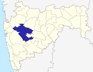
Ahmednagar district is the largest district of Maharashtra state in western India. The historical Ahmednagar city is the headquarters of the district. Ahmednagar was the seat of the Ahmednagar Sultanate of late medieval period. This district is known for the towns of Shirdi associated with Sai Baba, Meherabad associated with Meher Baba, Shani Shinganapur with Shanidev, and Devgad with Lord Dattatreya. Ahmednagar district is part of Nashik Division. Sangamner is the biggest city by development, market, and population, after the city of Ahmednagar.
Kasara is a census town in Thane district in the Indian state of Maharashtra. The town is on the busy Mumbai–Nashik route, which is one of the four major routes that lead into Mumbai. Kasara is served by a railway station on the Mumbai Suburban Railway, and is the final stop in the north-east sector of the Central Line and important railway station. That is for abbreviation for Kasara Local is set as "N" means North side Local's Last Station. Town is also known for the winding Kasara ghat pass.
Lasalgaon is a census town in Nashik District in the Indian state of Maharashtra.
Sangamner is a city and a municipal council located in the Ahmednagar District of Maharashtra state in India. Situated on the Pravara River, it got its name because it is on the site of the sangam (confluence) of three rivers in the area: Pravara, Mhalungi, and Adhala. Industries include a cloth market, educational facilities, a sugar factory, agriculture, and tobacco products known as Gaichap Jarda.Sangamner is the second largest city in the district after the city of Ahmednagar and is famous for its huge market as well as educational facilities, milk processing industries. Sangamner is also known as "Hospital hub" of the district. The city is enjoying central location & is just 2hrs from Nasik on the Pune Nasik national highway. Already famous for sugarcane farming, Sangamner is now known as Tomato as well as pomegranate hub. The 'Krushi Utpanna bajar samiti' of Sangamner is considered as one of the major markets in the country. Already known as mostly traffic city of the district, now nasik pune railway is under proposal with major terminal at the sangamner city. Due to central location, the bus stand of the city is open 24 hours with high level of public transport. MSRTC terminal at Sangamner is the most high tech bus station in Maharashtra state. Buses of Gujrat, Karnataka and Madhya Pradesh also comes here everyday.
Sinnar is a city and a municipal council in Sinnar taluka of Nashik district in the Indian state of Maharashtra.
Surgana is a census town and taluka in Nashik District in the Indian state of Maharashtra.

Upleta is a city and tehsil in the Rajkot district of the state of Gujarat, India. It contains within it two towns and 49 villages.
Satana is a city and a municipal council in Nashik District in the Indian state of Maharashtra. It is in the taluka of Baglan, which is sometimes called Satana, because of the city's dominance in the taluka. The name "Satana" may be derived from "Śāṭyāyani" one of the minor Upanishads of the Muktika canon.
Peth is the smallest tehsil of Nashik subdivision of Nashik district in Maharashtra, India. It belongs to Khandesh and Northern Maharashtra region. It belongs to Nashik Division. Peth is a Taluka headquarter. It is located 54 km to the north of District headquarters Nashik. It is also called as Peth. Peth Pin code is 422208 and postal head office is Peth.
The Roman Catholic Diocese of Nashik is a diocese located in the city of Nashik in the Ecclesiastical province of Bombay in India.
Nampur is a village in Nashik District of Maharashtra, India. As per census of 2011 by Govt of India It is situated near Satana also called as Baglan Taluka, the headquarters for Baglan Taluka, at the distance of 21 km. Nampur is known in the states of Maharashtra, Karnataka and Gujarat for its cattle market. It is near to Gujarat and is a major transportation hub. It is 35 kilometers from the city of Malegaon and 25 from Taharabad on the road (SH-16) to Gujarat. The first MLA elected from Baglan Taluka was from Tembhe which is just 7 km from Nampur. In the 2001 census, the village of Nampur had 12,458 inhabitants, with 6,386 males (51.3%) and 6,072 females (48.7%), for a gender ratio of 951 females per thousand males
Patole is a village in Sinnar taluka of Nashik district in the Indian state of Maharashtra. The current sarpanch of Patole is Shri Meghraj Suresh Avhad who is a civil engineer.
Kashti is a panchayat village in the state of Maharashtra, India. Administratively, Kashti is under Malegaon Taluka of Nashik District in Maharashtra. Kashti is the only village in its gram panchayat. The village is located on the right (southwest) bank of the Mausam River, 29 km by road southeast of the village of Nampur, and 37 km by road north-northwest of the city of Malegaon.
Malegaon MIDC is an industrial zone in the Sinnar taluka of Nashik district, Maharashtra state, India. It is located 6 kilometres (3.7 mi) from the city of Sinnar.
Mahiravani is a historical village in Nashik district of Maharashtra state of India. It is on the way from Nashik to Trimbakeshwar. The population of the village is around two thousand. Spoken language is Marathi.
Ahivant Fort / अहिवंत किल्ला is a fort located 55km from Nashik, in Nashik district, of Maharashtra. This fort is an important fort in Nashik district. The three forts Achala, Ahivant, and Mohandar are very close by. The other two forts were constructed to guard the Ahivant fort. Captain Briggs has described it as a large and shapeless hill, remarkably bleak and unhealthy

