
Buldhana district is located in the Amravati division of Maharashtra, India. It is situated at the western border of Vidarbha region and is 500 km away from the state capital, Mumbai. The district has towns and cities like Shegaon, Jalgaon Jamod, Malkapur, Khamgaon, Lonar, Mehkar, and Chikhli. It is surrounded by Madhya Pradesh in the north, Akola, Washim, and Amravati districts on the east, Jalna district on the south, and Jalgaon and Aurangabad districts on the west. Khamgaon is the largest city in the district. Latitudes are 19.51° to 21.17° N and longitudes are 75.57° to 76.59° E.

Nashik district, also known as Nasik district, is a district in Maharashtra, India. The city of Nashik is the administrative headquarters of the district. Nashik is well known for the production of wine. Nashik is also known as Mini Maharashtra, because the climate and soil conditions of Surgana, Peth, Igatpuri resembles with Konkan. Niphad, Sinnar, Dindori, Baglan blocks are like Western Maharashtra and Yeola, Nandgaon, Chandwad blocks are like Vidarbha Region. Nashik is the biggest city in the district while Malegaon is the second biggest city. Manmad, Igatpuri, sinnar are some of the big cities situated in the Nashik District. Manmad is one of the biggest railway junction in india while the city of Malegaon is famous for its powerloom.

Niphad is the name both of the town and the Taluka headquartered there. It is within the Nashik District of Maharashtra, India. The Marathi name signifies "a place without mountains", and indeed the taluka's topography is fairly level, with hardly any hills. It is served by Niphad railway station. Niphad's latitude and longitude coordinates are 20°5′0″N74°7′0″E. Located northeast of Nashik city, the Taluka borders Sinnar, Nashik, Dindori, Chandwad, and Yeola Talukas and Ahmednagar District, and has no direct access to the sea. The Niphad Sub-Division is composed of Niphad, Sinnar and Yeola Talukas.

Khandeshi is a language spoken in the Maharashtra state of India. It is spoken in the Khandesh region wedged between the territory of Bhili and that of Marathi. It consists of Khandeshi proper, and the Dangri and Ahirani dialects. The words "Ahirani" and "Khandeshi" are sometimes used interchangeably: Ahirani as the caste-based name, and Khandesh as the region-based name.

Oddanchatram is a town in Dindigul district in the Indian state of Tamil Nadu. Oddanchatram is a region in the southwest of Tamil Nadu. The Town was carved out of Madurai District in 1985. Oddanchatram is also famous for vegetable and cattle market. As of 2011, the town had a population of 30,064. It is known as vegetable city of Tamil Nadu. Oddanchatram vegetable market is the largest supplying of vegetables in Tamilnadu and Kerala. Agriculture is the major economic support for the town.
Kalavai is a panchayat town in Ranipet district in the Indian state of Tamil Nadu. The main occupation represented in the area is farming. The town has a pond and a lake after rainy season. Villagers use the lake water and palar river for irrigation. Corporation Bank, State Bank Of India and Indian Bank are the banks that have branches in the locality. The secondary occupation is garment outlets. One government higher secondary school is also located in a nearby village.
Manchar is a census town and Nagar panchayat in Ambegaon taluka of Pune district in the Indian state of Maharashtra. Nearby villages are Kalamb, Pimpalgoan and Landewadi. It is governed by Manchar Nagar Panchayat which is second Nagar panchayat in Pune district.
V. Pudur is a panchayat town in Thoothukudi district in the Indian state of Tamil Nadu.

Aundha Naganath is a town in the Aundha Nagnath subdivision of Hingoli district. It lies in the Marathwada region of the Indian state of Maharashtra. The town is known for the Aundha Nagnath Temple, it is the 8th Jyotirling out of 12 which is dedicated to Shiva. The famous tourist spot along with the Temple includes the beautiful Garden and the Reserved Forest Region on the outskirts of the town.
Atpadi is an administrative town of the Atpadi Taluka of Sangli District in the Indian state of Maharashtra. Atpadi is located north-east of Sangli District and shares borders with the adjacent Solapur and Satara Districts. The town has a taluka administrative office, a courthouse, a police station, a government-run primary hospital, various schools and colleges and a theater. Atpadi's economy is based on the cultivation and sale of agricultural products, with pomegranates and cotton constituting the core of the industry. The town is also home to the Manganga Sahakari Sugar factory, a Pomegranate auction center and various small scale industries in fields such as manufacturing, processing, servicing and repairs.
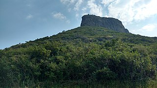
Dhodap, is one of the hill forts in Maharashtra state in India. Situated in Chandwad taluka in the Nashik district. the fort is 4829 ft above sea level. It is the site of the second highest fort in the Sahyadri mountains after Salher. Dhodap hill is the second highest hill peak in Maharashtra after Kalsubai and Salher and the 29th highest peak in Western Ghats.
Arni is a town with & tehsil in Yavatmal district of Maharashtra State in India. It is situated on the banks of the Arunavati River. It Connected with National Highway-361. Nearest Railway Station is a Dhamangaon which is located 90 km approx & Nearest Airport is a Dr.Babasaheb Ambedkar International Airport, Nagpur is around 187 km from Arni.
Pimpalgaon Baswant is a city in Nashik district, Maharashtra, India. It lies 30 km north of Nashik on the NH3. With the new national highway numbering, it lies on NH60. It is well connected with a six lane motorway with Nashik. Its geographical coordinates are 20° 10' 0" North, 73° 59' 0" East. It is situated on the banks of a small river Parashari. It derives its name Baswant from the local deity Baswanteshwar located inside the old town, this also helps to distinguish this town from other towns having the same first name.
Nampur is a village in Nashik District of Maharashtra, India. As per census of 2011 by Govt of India It is situated near Satana also called as Baglan Taluka, the headquarters for Baglan Taluka, at the distance of 21 km. Nampur is known in the states of Maharashtra, Karnataka and Gujarat for its cattle market. It is near to Gujarat and is a major transportation hub. It is 35 kilometers from the city of Malegaon and 25 from Taharabad on the road (SH-16) to Gujarat. The first MLA elected from Baglan Taluka was from Tembhe which is just 7 km from Nampur. In the 2001 census, the village of Nampur had 12,458 inhabitants, with 6,386 males (51.3%) and 6,072 females (48.7%), for a gender ratio of 951 females per thousand males
Vadgaon is a census town in Nashik district in the Indian state of Maharashtra.
Sakkaramallur is an Indian village panchayat located in Arcot Taluk of Vellore District in the state of Tamil Nadu. Sakkaramallur is located on Right Bank of Palar River.

Bhendali village is situated in Niphad Taluka of Nashik district, Maharashtra State, India.
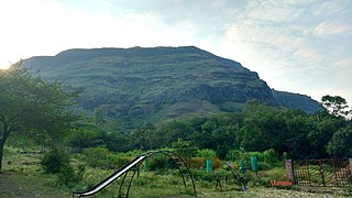
Indrai Fort / Indragiri Fort is a fort located 75 km from Nashik, in Nashik district, of Maharashtra. This fort though is an important fort in Nashik district but, it is less visited by the trekkers. In Chandwad taluka, there are 4 forts in a line on the Satmal hill range, the Chandwad fort, Indrai fort, Rajdher fort, and Koldher fort. This fort is easy to climb but requires 3 hours to reach the fort.
Chandwad Fort is located 3 kilometres (1.9 mi) from Chandwad, Nashik district, of Maharashtra.
Panewadi is village in Nandgaon Taluka near manmad, belongs to Khandesh and Northern Maharashtra region in Nashik district. It is located 95 KM towards East from District head quarters Nashik, 260 KM from State capital Mumbai. Khadgaon (6 ), Mohegaon (6 ), Karhi (6 ), Kundalgaon (9 ), Laxminagar (9 )) are the nearby Villages to Panewadi. Panewadi is surrounded by Yeola Taluka to the south, Chandwad Taluka to the west, Malegaon Taluka to the north, and Deola Taluka to the west. It is one of the 100 villages of Nandgaon Block of Nashik district. The village is home to 2842 people, among them 1472 (52%) are male and 1370 (48%) are female. 78% of the whole population are from general caste, 10% are from schedule caste and 12% are schedule tribes. Child population of Panewadi village is 16%, among them 54% are boys and 46% are girls. According to the administration register, the village code of Panewadi is 550317. The village has 498 houses.

