
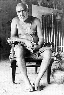
Sai Baba of Shirdi, also known as Shirdi Sai Baba, was an Indian spiritual master who is regarded by his devotees to be a manifestation of Sri Dattaguru and identified as a saint and a fakir. He was revered by both his Hindu and Muslim devotees during, as well as after his lifetime.

Ahmednagar is a city in Ahmednagar district in the state of Maharashtra, India, about 120 km northeast of Pune and 114 km from Aurangabad. Ahmednagar takes its name from Ahmad Nizam Shah I, who founded the town in 1494 on the site of a battlefield where he won a battle against superior Bahamani forces. It was close to the site of the village of Bhingar. With the breakup of the Bahmani Sultanate, Ahmad established a new sultanate in Ahmednagar, also known as Nizam Shahi dynasty.

Shirdipronunciation (help·info) also known as Sainagar is a city in the Indian state of Maharashtra. It is located in the Rahata taluka of Ahmednagar District. It is accessible via the Ahmednagar–Malegaon State Highway No.10, approximately 83 km from Ahmednagar and 15 km from Kopargaon. It is located 185 km east of the Western Seashore line, a very busy route.

Nashik Road is a suburb of Nashik that contains the city's railway station. The name 'Nashik Road' was originally used for the town surrounding the station and parts of the adjoining Deolali village, but has been administratively merged with the Nashik Municipal Corporation since the year 1984. Nashik Road is one of the fastest growing suburbs of the area, with almost 575,000 residents.
Niphad is the name both of the town and the Taluka headquartered there. It is within the Nashik District of Maharashtra, India. The Marathi name signifies "a place without mountains", and indeed the taluka's topography is fairly level, with hardly any hills. It is served by Niphad railway station.Niphad's latitude and longitude coordinates are 20°5′0″N74°7′0″E. Located northeast of Nashik city, the Taluka borders Sinnar, Nashik, Dindori, Chandwad, and Yeola Talukas and Ahmednagar District, and has no direct access to the sea. The Niphad Sub-Division is composed of Niphad, Sinnar and Yeola Talukas.
Upasni Maharaj, born Kashinath Govindrao Upasni, was considered by his disciples to be a satguru. He lived in Sakori, British India, and is said to have received God-realization from Sai Baba of Shirdi. Sakori is located in Ahmednagar District of Maharashtra, about 5 kilometres (3 mi) from Shirdi.
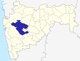
Ahmednagar district is the largest district of Maharashtra state in western India. The historical Ahmednagar city is the headquarters of the district. Ahmednagar was the seat of the Ahmednagar Sultanate of late medieval period. This district is known for the towns of Shirdi associated with Sai Baba, Meherabad associated with Meher Baba, Shani Shinganapur with Shanidev, and Devgad with Lord Dattatreya. Ahmednagar district is part of Nashik Division. Sangamner is the biggest city by development, market, and population, after the city of Ahmednagar.
Sinnar is a city and a municipal council in Sinnar taluka of Nashik district in the Indian state of Maharashtra.
Umarga/ Omerga is a town with a municipal council in the Osmanabad district in the Indian state of Maharashtra. It is an administrative headquarter of the Umarga Tehsil.

Saptashrungi or Saptashringi is a site of Hindu pilgrimage situated 60 kilometres (37 mi) from Nashik in Indian state of Maharashtra. According to Hindu traditions, the goddess Saptashrungi Nivasini dwells within the seven mountain peaks. It is located in Nanduri, Kalwan taluka, a small village near Nashik in India. The Marathas and some Bhil tribes worship the goddess from a long time and some worship as their kuldaivat. There are 510 steps to climb the gad. Devotees visit this place in large numbers every day. The temple is also known popularly as one of the "three and half Shakti Peethas" of Maharashtra. The temple is also one among the 51 Shakti Peethas located on the Indian subcontinent and is a location where one of Sati's limbs, her right arm is reported to have fallen. Its half shaktipeeth among three and half shaktipeeth of Maharashtra.
Sakri is a census town and a taluka in the Dhule District of the Nashik division, Maharashtra state, India. The town of Sakri is the administrative headquarters for Sakri Taluka. Another Sakri is in Bihar, which is now a railway junction.

The economy of Maharashtra is the largest in India. It is one of the most urbanised of Indian States.
Paangari is a village in Sinnar Talkuka of Nashik District, Maharashtra. It is on Mumbai-Shirdi highway and many find it a suitable location for rest during their journey. It is approximately 270 km from Mumbai.
Patole is a village in Sinnar taluka of Nashik district in the Indian state of Maharashtra. The current sarpanch of Patole is Shri Meghraj Suresh Avhad who is a civil engineer.
Maharashtra is a state in the western region of India. It is the second most populous state and third largest state by area in India. Maharashtra is bordered by the Arabian Sea to the west, Gujarat and the Union territory of Dadra and Nagar Haveli to the northwest, Madhya Pradesh to the north and northeast, Chhattisgarh to the east, Karnataka to the south, Telangana to the southeast and Goa to the southwest. The state covers an area of 307,731 km2 (118,816 sq mi) or 9.84% of the total geographical area of India.
Malegaon MIDC is an industrial zone in the Sinnar taluka of Nashik district, Maharashtra state, India. It is located 6 kilometres (3.7 mi) from the city of Sinnar.

The Gargoti Museum is a museum in the town Sinnar near Nashik in Indian state of Maharashtra that houses a collection of natural mineral & gem specimens collected by K.C.Pandey over 40 years. The word "goti" refers to a Marathi word meaning stone or pebble. This is India's 1st & only Gem, Mineral & Fossil Museum. It is the world's biggest “Private” Gem & Mineral Museum. It also houses the largest & the finest collection of Indian Zeolite Minerals & Crystals in the world.
Pimpalas is the name both of the town. It is within the Nashik District of Maharashtra, India. The Marathi name signifies "a place without mountains", and indeed the taluka's topography is fairly level, with hardly any hills. It is served by Kasabe Sukena railway station.pimpalas's latitude and longitude coordinates are 20°5′0″N74°7′0″E. Located northeast of Nashik city, the Taluka borders Sinnar, Nashik, Dindori, Chandwad, and Yeola Talukas and Ahmednagar District, and has no direct access to the sea.
National Highway 160, commonly referred to as NH 160 is a national highway in India. It is a spur road of National Highway 60. NH-160 traverses the states of Maharashtra and Karnataka in India.
Pathare Budruk is a village in Sinnar taluka of Nashik district in the Indian state of Maharashtra. It is located along Nashik-shirdi road 20 km before Shirdi.