
Vidisha is a city in central Madhya Pradesh, India. It is located 62.5 km northeast of the state capital, Bhopal. The name "Vidisha" is derived from the nearby river "Bais", mentioned in the Puranas.
Kurwai is a town and a Nagar Panchayat in Vidisha district in the Indian state of Madhya Pradesh. its also tehsil headquarter and assembly constituency.

Raisen District is a district of Madhya Pradesh state of India. The town of Raisen is the district headquarters. The district is part of Bhopal Division. Sanchi University of Buddhist-Indic Studies is the first international university located at Sanchi Town.

Satna is a city in the Indian state of Madhya Pradesh. It serves as the headquarters of Satna district. It is 7th largest city and 8th most populous city of the state. The city is 500 km east of the state capital Bhopal. The city is distributed over a land area of 111.9 square kilometres.

Guna district is one of the 52 districts of Madhya Pradesh in central India. Its administrative headquarters is Guna. The district has a population of 1,241,519. It has an area of 6390 km², and is bounded on the northeast by Shivpuri District, on the east by Ashoknagar District, on the southeast by Vidisha District, on the southwest by Rajgarh District, on the west and northwest by Jhalawar and Baran districts of Rajasthan state. The Sindh River flows northward along the eastern edge of the district, forming part of the boundary with Ashoknagar District, and the Parvati River flows northwestward through the southern portion of the district, forming part of the boundary with Baran District before flowing into Rajasthan.

Vidisha District (विदिशा) is in Madhya Pradesh state, in central India. The city of Vidisha is the administrative headquarters of the district.

Bhopal District is a district of Madhya Pradesh state in central India. The city of Bhopal serves as its administrative headquarters. The district is part of Bhopal Division.
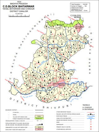
Bhitarwar is a city and a municipality in Gwalior district in the state of Madhya Pradesh, India. The town is surrounded by a river called Parbati.
Ichhawar is a town, and a Municipal Council in Sehore district in the Indian state of Madhya Pradesh. Ichhawar is near Bhopal state capital. Nearest railway station sehore. Nearest airport Bhopal.

Mauganj is the administrative headquarter of Mauganj district in Madhya Pradesh. Bagheli is the regional language of Mauganj. Mauganj is the seat of legislative assembly in Madhya Pradesh. Its nearest towns are Manikwar, Hanumana, Deotalab, Naigadhi.

Naigarhi is a rural town in the Rewa district of Madhya Pradesh, India. It was founded by a Sengar Rajput king, Raja Chattradhari Singh. The town is notable for its medieval era architecture constructed by the Sengar kings.
Raghogarh-Ruthiyai or Raghogarh-Vijaypur is a town and municipality in Guna district in the Indian state of Madhya Pradesh.
Sarangpur is a city and tehsil in Rajgarh district in the Indian state of Madhya Pradesh. It is situated at the bank of the river Kali Sindh.
Susner is a town and a Nagar panchayat and Sub division in Agar Malwa district in the Madhya pradesh state of India. Its also a tehsil and a assembly.
Narsinghgarh is a town and a municipality, near Rajgarh city in Rajgarh district in the Indian state of Madhya Pradesh.

Surkhi Assembly constituency is one of the 230 Vidhan Sabha constituencies of Madhya Pradesh state in central India. This constituency came into existence in 1951, as one of the Vidhan Sabha constituencies of Madhya Pradesh state.
Kurwai is one of the 230 Vidhan Sabha constituencies of Madhya Pradesh state in central India. This constituency came into existence in 1957, as one of the Vidhan Sabha constituencies of Madhya Pradesh state. This constituency is reserved for the candidates belonging to the Scheduled castes since 1977, following the delimitation of the Legislative Assembly constituencies.

Sironj Assembly constituency is one of the 230 Vidhan Sabha constituencies of Madhya Pradesh state in central India. This constituency came into existence in 1957, as one of the Vidhan Sabha constituencies of Madhya Pradesh state.

Pathari is a town in Vidisha district, it's also a tehsil headquarter. Many tourist attractions in the Indian state of Madhya Pradesh loceted here.

Mauganj district is one the districts of Madhya Pradesh. The administrative headquarters is at Mauganj. The district was carved out from the existing Rewa district on 15 August 2023 and was announced by then Chief Minister Shivraj Singh Chouhan.
