Madhya Pradesh is a state in central India. Its capital is Bhopal, and the largest city is Indore, with Gwalior, Jabalpur, Ujjain, Dewas, Sagar, Satna, and Rewa being the other major cities. Madhya Pradesh is the second largest Indian state by area and the fifth largest state by population with over 72 million residents. It borders the states of Uttar Pradesh to the northeast, Chhattisgarh to the east, Maharashtra to the south, Gujarat to the west, and Rajasthan to the northwest.

Indore is the largest and most populous city in the Indian state of Madhya Pradesh. It is consistently ranked as the cleanest city in India. It serves as the headquarters of both the Indore District and the Indore Division. It is also considered as the state education hub and houses campuses of both the Indian Institute of Technology and the Indian Institute of Management. Located on the southern edge of Malwa Plateau, at an average altitude of 553 meters (1,814 ft) above sea level, it has the highest elevation among major cities of Central India. The city is 190 km (120 mi) west of the state capital of Bhopal. It is 57 km from Ujjain and 35 kms from Dewas. Indore had a census-estimated 2011 population of 1,994,397 and 3,570,295. The city is distributed over a land area of just 530 square kilometres (200 sq mi), making Indore the most densely populated major city in the central province.

Khandwa is a city and a nagar nigam in the Nimar region of Madhya Pradesh, India. It is the administrative headquarters of the Khandwa district, formerly known as East Nimar District.

Dewas is a city in the Malwa region of the Indian state of Madhya Pradesh. The municipality was formerly the seat of two 15-Gun Salute state princely states during the British Raj, Dewas Junior state and Dewas Senior state, ruled by the Pawar clan of the Marathas. The city is the administrative capital of Dewas district. Dewas is an industrialised city and houses a government bank note press.
Harda is a town and a municipality in Harda district in the Indian state of Madhya Pradesh. Harda is the administrative headquarters of Harda.
Mandleshwar is a town and nagar panchayat in the Khargone district of the India state of Madhya Pradesh. It is on the banks of Narmada River, 8 kilometres (5.0 mi) east of Maheshwar and 99 kilometres (62 mi) south of Indore. It is a "Pavitra nagri" as termed by the government of Madhya Pradesh, as it is an ancient town. It is the education centre of Maheshwar block, the location of the district court and district jail of Khargone, and is also the political centre of Maheshwar block.

Dewas District is a district in the Indian state of Madhya Pradesh. The town of Dewas is the district headquarters.

Rajgarh district is a district of Madhya Pradesh in central India. The city of Rajgarh is the administrative headquarters of the district. The old name of Rajgarh was Jhanjhanipur. Rajgarh in Madhya Pradesh is one of the aspirational districts selected by Government of India. The district has an area of 6,154 km² and the population is 1,545,814. The district lies on the northern edge of the Malwa plateau, and the Parbati River forms the eastern boundary of the district, while the Kali Sindh River forms the western boundary. The district has seven tehsils, Rajgarh, Khilchipur, Jirapur, Biaora, Narsinghgarh, Sarangpur and Pachore. The district is bounded by Rajasthan state to the north, and by the districts of Guna to the northeast, Bhopal to the east, Sehore to the southeast, and Shajapur to the south and west. It is part of Bhopal Division. There are 1728 villages in Rajgarh.

Khargone is a city and administrative headquarters of an Khargone district in the Indian state of Madhya Pradesh. The city is located on the bank of the Kunda river and is known for its cotton and chilly production. It is also known for Navgraha Mandir, a temple devoted to the nav grahas. Khargone topped the nation in municipality and received a national award for 'India's Fastest Moving City' under a population of two lakh. Khargone ranked 10th Cleanest city in India in Swachh Survekshan 2020 City ranked the 15th cleanest city in India in Swachh Survekshan 2018 and ranked 17th cleanest city in India in Swachh Survekshan 2017.

Parikrama or Pradakshina is clockwise circumambulation of sacred entities, and the path along which this is performed, as practiced in the Indic religions – Hinduism, Buddhism, Sikhism and Jainism. In Buddhism, it refers only to the path along which this is performed. Typically, in Indic-religions the parikrama is done after completion of traditional worship and after paying homage to the deity. Parikrama must be done with dhyāna.
Barwaha is a municipality and tehsil in Khargone district in the state of Madhya Pradesh, India. Barwaha is second biggest city of District after Khargone city. The Barwaha city is divided into 18 wards for which elections are held every 5 years. The Barwaha Municipality has population of 39,973 of which 20,940 are males while 19,033 are females as per report released by Census India 2011. Literacy rate of Barwaha is 87.27% higher than state average of 69.32%. In Barwaha, Male literacy is around 92.73% while female literacy rate is 81.23%.
Bhainsdehi is a city and a Nagar Parishad in Betul district in the state of Madhya Pradesh, India. Kukru is the second highest point of Mahadeo hills. Bhainsdehi is the originating place of the river Purna. It is predominantly a tribal tehsil. Bhainsdehi is surrounded by the mountain ranges of Satpura. Prachin Shiv mandir one of the most beautiful place in Bhainsdehi city
Kasrawad is a tehsil and nagar panchayat in Khargone district in the Indian state of Madhya Pradesh.
Mundi is a city and Tehsil in the Khandwa district of Nimar region the Indian state of Madhya Pradesh. It is situated in North Side of East Nimar District.
Satwas is a town and a Nagar Panchayat in Dewas district in the Indian state of Madhya Pradesh. Satwas is around 136.8 km (85.0 mi) from Dewas.
Sonkatch is a town and a Nagar panchayat in Dewas district in the Indian state of Madhya Pradesh.

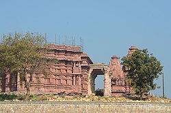
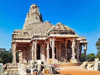
Bhumija is a variety of north Indian temple architecture marked by how the rotating square-circle principle is applied to construct the shikhara on top of the sanctum. Invented about the 10th-century in the Malwa region of central India during the Paramara dynasty rule, it is found in Hindu and Jain temples. Most early and elegant examples are found in and around the Malwa region, but this design is also found in Gujarat, Rajasthan, Deccan and some major Hindu temple complexes of southern and eastern India.
Banapura is a small town in the Hoshangabad District of Madhya Pradesh, India. Banapura is a twin city of Seoni Malwa.
Sarvodaya Jain temple is a Jain temple in Amarkantak town in Anuppur, Madhya Pradesh. Nearest airport is Raipur C.G. and nearest railway station is Pendra road C.G. You can also reach easily from Bilaspur CG and Anuppur MP, by Car. Rental car, taxi and auto rickshaw are easily available From Pendra Road. Many Lodges, Ashram and Hotels are available in Amarkantak and as well as Pendraroad. Amarkantak is a well-known Teerth. It is famous for beautiful Nature, mountains and climate. Ma Narmada Temple, Narmada kund, Kapil dhara, Dudh Dhara, Son muda, Mai ki bahiya, Durga dhara, Bhrigu kamandal, Arandi ashram, Kalyan ashram and many more attractive places are Beauty of Amarkantak. Beauty and architecture of Sarvoday Jain temple is also remarkable.