Bhanpura | |
---|---|
Town | |
Coordinates: 24°31′N75°44′E / 24.52°N 75.73°E | |
Country | India |
State | Madhya Pradesh |
District | Mandsaur |
Elevation | 384 m (1,260 ft) |
Population (2001) | |
• Total | 16,493 |
Languages | |
• Official | Hindi |
Time zone | UTC+5:30 (IST) |
Vehicle registration | MP-14 |
Bhanpura is a town and a nagar panchayat in Mandsaur district, located in the state of Madhya Pradesh, India. Bhanpura was discovered by King Bhanu bhil. It was also ruled by the Chandrawats of Mewar during the times of Rana Sanga's rule. The town is home to a number of historic places such as the Daraki-Chattan region, which is one of the world's oldest rock arts, [1] Chaturbhujnath Nala rock art shelters, and the Hinglajgarh Fort. Bhanpura also has a museum that displays the popular arts of Mandsaur, including art from the Gupta era (4th–5th century) until the time of Pratiharas and Parmaras. [2]
The excavation at Daraki-Chattan revealed immense information on the cultural occupation of the site. Daraki-Chattan is a small and narrow cleft or cave in the tall cliff faces of Indragarh Hill in the Vindhya range, overlooking the Rewa river valley. [3] The cave is approximately 1.4 metres (4.6 ft) wide at its mouth, from where it continuously narrows down in width, finally closing at the depth of 8.4 m (28 ft) from its mouth. The cave is approximately 7.4 m (24 ft) in height. [4] It bears more than five hundred deeply patinated cupules on both of its vertical walls. [5] The Daraki-Chattan cupules were discovered by Ramesh Kumar Pancholi in 1992. The Archaeological Survey of India took up Daraki-Chattan region near Bhanpura as a case for the study of early petroglyphs in India, and commenced excavation under Giriraj Kumar in 2002. [6]
Daraki-Chattan reveals the past of an extensive rock art in this cave. The collection of stone artifact assemblage from the excavation undoubtedly reveals that the shelter was occupied by the Acheulean man. The experts studying the petroglyphs claim it to be the "oldest rock art in the world", about 2 to 5 lakh (200,000–500,000) years old. [7]
In order to study the early cupules in India, an international project called "Early Indian Petroglyphs" was established in 2000. It is a joint venture by researchers from Rock Art Society of India (RASI) and Australian Rock Art Association (AURA), under the supervision of the International Federation of Rock Art Organizations (IFRAO), Robert Bednarik and Giriraj Kumar. [3]
Bhanpura gets its name from a king named Bhaman. [2] It was ruled by the Chandrawats of Mewar in the 16th century. Chandrawat of Bhanpura held the title of 'Rao'. The Chandrawats descend from Chanda Singh, and were powerful chiefs in Mewar. They migrated from Mewar due to internal strife. [8] [9]
Bhanpura is located at 24°31′N75°44′E / 24.52°N 75.73°E . [10] It has an average elevation of 384 metres (1,259 feet). Bhanpura is 127 km (79 mi) north-east of Mandsaur, and south of Hinglajgarh and Navali in Mandsaur district.
As of 2001 [update] India census, [11] Bhanpura had a population of 16,493. Males constituted 51% of the population and females 49%. Bhanpura had an average literacy rate of 70%, higher than the national average of 59.5%; with male literacy of 80% and female literacy of 61%. 13% of the population was under 6 years of age.
Hinglajgarh or Hinglaj Fort is an ancient fort situated near Navali village in the Bhanpura tehsil of Mandsaur district in Madhya Pradesh. It is located at 25°30' N 65°31' E. It is situated at a distance of 165 km (103 mi) from Mandsaur and 26 km (16 mi) from Bhanpura in Madhya Pradesh. [12] This fort was at its peak of grandeur during the Parmara rule. [13] There are many artistic sculptures of various periods in this fort. The Nandi and Uma-Maheshwar sculptures were sent from here to France and Washington for display in Indian festivals. [14] Hinglajgarh has been the centre of excellence in craftsmanship of sculptures for about 800 years. The statues recovered from this fort are from Gupta period to the Parmara period. The most ancient statues are from 4th to 5th century AD. [15]
Chaturbhujnath Nala rock art shelters were discovered in 1973,by Dr. Ramesh kumar pancholi [16] and are one of the Longest Rock Art Galleries in the world. [7] They are situated near the Gandhi Sagar Sanctuary, 30 kilometres (19 mi) from Bhanpura in the Mandsaur district of Madhya Pradesh. It is located along a perennial stream called the Chaturbhujnath Nala, stretching in a 5-kilometre-long (3.1 mi) rock art gallery, with thousands of figures painted on its walls. According to carbon dating, the paintings are around 35,000 years old. [16] The rock shelters differ from the rock caves of Bhimbetka, because they are isolated and relatively narrow. [17] [18]
Gandhi Sagar Sanctuary is a wildlife sanctuary situated on the northern boundary of Mandsaur and Nimach districts in Madhya Pradesh, India. It is spread over an area of 368.62 km2 (142 sq mi) adjoining the state of Rajasthan in India. It was created in 1974 and expanded in 1983. The Chambal River passes through the sanctuary and divides it into two parts: the western part is in Nimach district and the eastern is in Mandsaur district.
Kethuli Jain temple is 21 km (13 mi) from Bhanpura, on the road towards Jhalrapatan. It is a famous 'Atishay Kshetra' attracting Jain pilgrims. The temple has a 500 year-old idol of Tirthankara Parshvanatha.
Village Kanwala is currently in discussion, due to which there is increasing tourism in the village, today this post is about the same place - Village Kanwala is located 8 km west of Bhanpura and is surrounded by the zenith of Mother Chambal. Two huge boulders are located on the banks of Chambal in the south, away from the population area of the village - these boulders are also called "chidi wala stone" in the village due to the beautiful mud houses of the ababil bird. When the west wind prevails, the huge, high waves of Chambal push the sand against the rocks located in the water and shape the edges, thus the sand has accumulated between the edges due to continuous waves. Throughout the day, the waves of Chambal collide with the shores to make them realize their vast nature, by the evening, with the wind, sometimes the enthusiasm of the waves increases, and sometimes when the opposite wind direction, the mother Chambal calms down and gives her softness. During the day, even the wild birds, bringing food for their chicks, leave their homes in the evening and keep circling continuously to register their presence in the sky. On the one hand the sun wants to pour out all the light with its last rays, while on the other hand, a flock of wild birds compete with the sky, thus with the sunset gradually everything starts to calm down.
And then Chambal also calms down, to hit the rocks again the next day... In these two huge rock blocks, there are also rock paintings made by primitive man millions of years ago, which are the development journey of man, these rocks.
Bhanpura has several educational institutions. There are many professional computer institutes and industrial training Institutes, and many colleges. Saraswati Vidya Mandir is a Hindi medium school. The residential C.B.S.E. affiliated school of the district is Smt Kamala Saklecha Gyan Mandir, which is situated 4 km (2.5 mi) away from Bhanpura.
By airBY Road
The Bhimbetka rock shelters are an archaeological site in central India that spans the Paleolithic and Mesolithic periods, as well as the historic period. It exhibits the earliest traces of human life in India and evidence of the Stone Age starting at the site in Acheulian times. It is located in the Raisen District in the Indian state of Madhya Pradesh, about 45 kilometres (28 mi) south-east of Bhopal. It is a UNESCO World Heritage Site that consists of seven hills and over 750 rock shelters distributed over 10 km (6.2 mi). At least some of the shelters were inhabited more than 100,000 years ago.
Mandsaur is a city and a municipality in Mandsaur district located on the border of Mewar and Malwa regions of Madhya Pradesh, a state in Central India. It is the administrative headquarters of Mandsaur District. The ancient Pashupatinath Temple is located in Mandsaur.
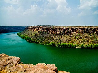
The Chambal River is a tributary of the Yamuna River in Central and Northern India, and thus forms part of the drainage system of the Ganges. The river flows north-northeast through Madhya Pradesh, running for a time through Rajasthan, then forming the boundary between Rajasthan and Madhya Pradesh before turning southeast to join the Yamuna in Uttar Pradesh state.
Mewar or Mewad is a region in the south-central part of Rajasthan state of India. It includes the present-day districts of Bhilwara, Chittorgarh, Pratapgarh, Rajsamand, Udaipur, Pirawa Tehsil of Jhalawar District of Rajasthan, Neemuch and Mandsaur of Madhya Pradesh and some parts of Gujarat.
Bhind district is a district in the Chambal division of the Indian state of Madhya Pradesh. The town of Bhind is the district headquarters.Bhind District is situated in Chambal region in the northwest of the state.
GandhisagarDam is situated at a distance of 168 km from the District headquarter. The Dam is constructed on the Chambal River.
Mandsaur district is a District of Madhya Pradesh state in central India. The town of Mandsaur is the administrative headquarters of the district.The ancient Pashupatinath temple is situated in Mandsaur. Large quantities of opium are produced in Mandsaur district.
Pashupatinath Temple at Mandsaur, also referred to as the Mandsaur Shiva temple, is a Hindu temple dedicated to Lord Shiva in Mandsaur, Madhya Pradesh, India. It belongs to Pashupatinath tradition which is one of 6 major tradition within Shaivism. It is located on Shivna River, and is known for its eight-faced Shiva Linga. The temple sculpture is dated to the 5th or 6th century based on inscriptions, with some referring to the site as Dashapura. It is near the Rajasthan border in the historic region of Malwa, about 200 kilometres (120 mi) from Indore, about 340 kilometres (210 mi) west of Udaigiri Caves and about 220 kilometres (140 mi) east of Shamalaji ancient sites, both a significant source of Gupta Empire era archaeological discoveries. The site has been important to dating and the architectural studies of some distant sites such as the Elephanta Caves.
Vishnu Shridhar Wakankar was an Indian archeologist. Wakankar is credited with the discovery of the Bhimbetka rock caves in 1957 and the Kayatha culture in 1964, among others. In 2003, UNESCO inscribed the Bhimbetka rock caves as a World Heritage Site. The Bhimbetka rock caves exhibit one of the earliest traces of human life in India.
Sabalgarh is a municipality in Morena district in the Indian state of Madhya Pradesh.
The Jawahar Sagar Dam is the third dam in the series of Chambal Valley Projects on the Chambal River, located 29 km upstream of Kota city and 26 km downstream of Rana Pratap Sagar dam. It is a concrete gravity dam, 45 meters high and 393 meters long, generating 60 MW of power with an installed capacity of 3 units of 33 MW. Its construction was completed in 1972. The dam's gross storage capacity is 67.07 million cubic meters. The total catchment area of the dam is 27,195 km2, of which only 1,496 km2 are in Rajasthan. The free catchment area below Rana Pratap Sagar dam is 2,331 km2. The dam is located after the Gandhi Sagar Dam and Rana Pratap Sagar Dam, but before the Kota Barrage.
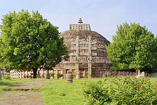
Tourism in Madhya Pradesh has been an attraction of India because of its location in the centre of the country. Madhya Pradesh has won Best Tourism State National award for 3 consecutive years i.e. 2017, 2016 and 2015.
Madhya Pradesh, often called the Heart of India, is a state in central India. Its capital is Bhopal. Madhya Pradesh was originally the largest state in India until November 1, 2000 when the state of Chhattisgarh was carved out. It borders the states Uttar Pradesh, Chhattisgarh, Maharashtra, Gujarat and Rajasthan.
Mandsaur Fort, is situated in Mandsaur city in Mandsaur district in Indian state of Madhya Pradesh.
Gandhi Sagar Sanctuary is a wildlife sanctuary situated on the northern boundary of Mandsaur and Nimach districts in Madhya Pradesh, India. It is spread over an area of 368.62 km2 (142.32 sq mi) adjoining Rajasthan state in India. It was notified in 1974 and more area was added in 1983. The Chambal River passes through the sanctuary dividing it into two parts. The western part is in Nimach district and eastern part is in Mandsaur district. It is in the Khathiar-Gir dry deciduous forests ecoregion.
Malwa Ki Sanskritik Virasat Evam Paryatan is a book written by Subhash Kumar Sojatia. It was released by Sonia Gandhi.
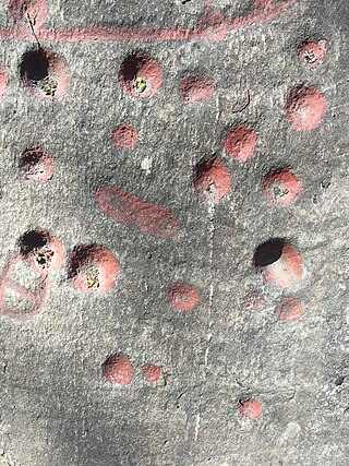
Rock cupules are artificially made depressions on rock surfaces that resemble the shape of an inverse spherical cap or dome. They were made by direct percussion with hand-held hammer-stones, on vertical, sloping or horizontal rock surfaces. Cupules are widely believed to be the world's most common rock art motifs, found in huge numbers in every continent except Antarctica. They were produced in many cultures, from the Lower Paleolithic to the 20th century, and they can be found on most lithologies. Similar artifacts from lithic Native American cultures are also known as cupstones.
Subhash Kumar Sojatia is an Indian politician and former Minister of Home, Health, Industry, Commerce, Medical Education and Public Relations in the Government of Madhya Pradesh. He was born on 30 March 1952 in the small town of Bhanpura, located in the Mandsaur District in the Malwa region of Madhya Pradesh. Sojatia received his education at Holkar Science College.
Hinglajgarh is an ancient fortress in Navali, Mandsaur District, Madhya Pradesh, India. The fortress has been controlled by multiple rulers, and has been rebuilt and revamped throughout the ages. The name Hinglajgarh comes from the Goddess Hinglaj Devi, of which a temple dedicated to her is located on the southern portion of the fortress. The fortress has also been described as a city or fortress city.