
India is the second most populated country in the world with a sixth of the world's population. According to official estimates in 2022, India's population stood at over 1.4 billion. According to UN forecasts, in 2023 India will overtake China and become the most populous country in the world.

Jammu and Kashmir was a region formerly administered by India as a state from 1952 to 2019, constituting the southern and southeastern portion of the larger Kashmir region, which has been the subject of a dispute between India, Pakistan and China since the mid-20th century. The underlying region of this state were parts of the former princely state of Jammu and Kashmir, whose western districts, now known as Azad Kashmir, and northern territories, now known as Gilgit-Baltistan, are administered by Pakistan. The Aksai Chin region in the east, bordering Tibet, has been under Chinese control since 1962.

Nagaland is a landlocked state in the northeastern region of India. It is bordered by the Indian states of Arunachal Pradesh to the north, Assam to the west, Manipur to the south, and the Sagaing Region of Myanmar (Burma) to the east. Its capital city is Kohima and its largest city is the twin Chümoukedima–Dimapur. The state has an area of 16,579 square kilometres (6,401 sq mi) with a population of 1,980,602 as per the 2011 Census of India, making it one of the smallest states in India.

The Scheduled Castes (SCs) and Scheduled Indian Tribes (SITs) are officially designated groups of people and among the most disadvantaged socio-economic groups in India. The terms are recognized in the Constitution of India and the groups are designated in one or other of the categories. For much of the period of British rule in the Indian subcontinent, they were known as the Depressed Classes.

Gurdaspur district is a district in the Majha region of the state of Punjab, India. Gurdaspur is the district headquarters. It internationally borders Narowal District of Pakistani Punjab, and the districts of Amritsar, Pathankot, Kapurthala and Hoshiarpur. Two main rivers Beas and Ravi passes through the district. The Mughal emperor Akbar is said to have been enthroned in a garden near Kalanaur, a historically important town in the district. The district is at the foothills of the Himalayas.

Bathinda district is in Malwa region of Punjab, India. The district encompasses an area of 3,385 square kilometers. By area, Bathinda district is the second-largest in Punjab, after Ludhiana District. It is bounded by Faridkot district and Moga district on the north, Muktsar district on the west, Barnala and Mansa districts on the east, and the state of Haryana on the south. Bathinda is cotton producing belt of Punjab.

Kapurthala district is a district of Punjab state in northern India. The city of Kapurthala is the district headquarters.
The decennialCensus of India has been conducted 16 times, as of 2021. While it has been undertaken every 10 years, beginning in 1872 under British Viceroy Lord Mayo, the first complete census was taken in 1881. Post 1949, it has been conducted by the Registrar General and Census Commissioner of India under the Ministry of Home Affairs, Government of India. All the censuses since 1951 were conducted under the 1948 Census of India Act, which predates the Constitution of India. The 1948 Census of India Act does not bind the Union Government to conduct the Census on a particular date or to release its data in a notified period. The last census was held in 2011, whilst the next was to be held in 2021. But it has been postponed due to the COVID-19 pandemic in India.
RannaBelagali is a Pattan Panchayat Town in the southern state of Karnataka, India. It is located in the Mudhol taluka of Bagalkot district in Karnataka

The 2011 Census of India or the 15th Indian Census was conducted in two phases, house listing and population enumeration. The House listing phase began on 1 April 2010 and involved the collection of information about all buildings. Information for National Population Register (NPR) was also collected in the first phase, which will be used to issue a 12-digit unique identification number to all registered Indian residents by Unique Identification Authority of India. The second population enumeration phase was conducted between 9 and 28 February 2011. Census has been conducted in India since 1872 and 2011 marks the first time biometric information was collected. According to the provisional reports released on 31 March 2011, the Indian population increased to 1.21 billion with a decadal growth of 17.70%. Adult literacy rate increased to 74.04% with a decadal growth of 9.21%. The motto of the census was 'Our Census, Our future'.
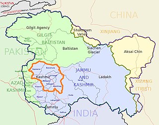
The Kashmir division is a revenue and administrative division of the Indian-administered Jammu and Kashmir. It comprises the Kashmir Valley, bordering the Jammu Division to the south and Ladakh to the east. The Line of Control forms its boundary with the Pakistani-administered territories of Gilgit−Baltistan and Azad Jammu and Kashmir to the north and west and west, respectively.

Jammu and Kashmir is a region administered by India as a union territory and consists of the southern portion of the larger Kashmir region, which has been the subject of a dispute between India and Pakistan since 1947, and between India and China since 1962. The Line of Control separates Jammu and Kashmir from the Pakistani-administered territories of Azad Kashmir and Gilgit-Baltistan in the west and north. It lies to the north of the Indian states of Himachal Pradesh and Punjab and to the west of Ladakh which is administered by India as a union territory.

