Bhaisunda

Last updated

Bhaisunda State
भैसुंदा राज्य
Princely Estate (Jagir)
1812–1948 Flag of India.svg
Bhaisunda flag.PNG Flag
Location of Bhaisunda Kothi-Bhaisunda map.jpg
Location of Bhaisunda
Bhaisunda State in the Imperial Gazetteer of India
History
  Established1812
   Independence of India 1948
Area
  190183 km2(32 sq mi)
Population
  19014,168 
Density 50.2 /km2  (130.1 /sq mi)

Bhaisunda, also spelt 'Bhaisaunda', was a princely state in India during the British Raj.

British Raj British rule in the Indian subcontinent, 1858-1947

The British Raj was the rule by the British Crown in the Indian subcontinent from 1858 to 1947. The rule is also called Crown rule in India, or direct rule in India. The region under British control was commonly called British India or simply India in contemporaneous usage, and included areas directly administered by the United Kingdom, which were collectively called British India, and those ruled by indigenous rulers, but under British tutelage or paramountcy, and called the princely states. The whole was also informally called the Indian Empire. As India, it was a founding member of the League of Nations, a participating nation in the Summer Olympics in 1900, 1920, 1928, 1932, and 1936, and a founding member of the United Nations in San Francisco in 1945.

Contents

History

Bhaisaunda state was founded in 1812 by the Kalinjar family. It was one of the Chaube Jagirs, which were part of the Bagelkhand Agency of British India.

Chaube Jagirs

The Chaube Jagirs, also known as 'Kalinjar Chaubes', jagir states were a group of five feudatory states of Central India during the period of the British Raj. They were a British protectorate from 1823 to 1947 and belonged to the Bagelkhand Agency. Their last rulers joined the Indian Union in 1948.

Bagelkhand Agency

The Bagelkhand Agency was a British political unit which managed the relations of the British with a number of autonomous princely states existing outside British India, namely Rewa and eleven minor states, of which the more important were Maihar, Nagod —with its capital at Uuchahara— and Sohawal. The less important states included Jaso State, Kothi, Baraundha, also known as Patharkachhar, as well as the Kalinjar Chaubes —consisting of the princely estates of Paldeo, Kamta-Rajaula, Taraon, Pahra and Bhaisaunda.

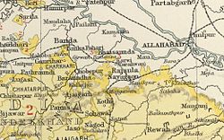
Practically all the inhabitants of the Jagir were Hindu. [1] The capital was the village of Bhaisunda, located at 25° 18′ N, 80° 48′ E.. In 1948, one year after Indian independence, Bhaisunda was merged into the Indian state of Vindhya Pradesh.

Partition of India partition of British India into the independent states of India and Pakistan in 1947

The partition of India in 1947 eventually accompanied the creation of two independent dominions, India and Pakistan. The Dominion of India became the Republic of India in 1950, and in 1957 the Dominion of Pakistan became the Islamic Republic of Pakistan. In 1971, the People's Republic of Bangladesh (Bangladesh) came into being after Bangladesh Liberation War. The partition involved the division of three provinces, Assam, Bengal and Punjab, based on district-wide Hindu or Muslim majorities. The boundary demarcating India and Pakistan came to be known as the Radcliffe Line. It also involved the division of the British Indian Army, the Royal Indian Navy, the Indian Civil Service, the railways, and the central treasury, between the two new dominions. The partition was set forth in the Indian Independence Act 1947 and resulted in the dissolution of the British Raj, as the British government there was called. The two self-governing countries of Pakistan and India legally came into existence at midnight on 14–15 August 1947.

Vindhya Pradesh former country

Vindhya Pradesh was a former state of India. It occupied an area of 23,603 sq. miles. It was created in 1948, shortly after Indian independence, from the territories of the princely states in the eastern portion of the former Central India Agency. It was named for the Vindhya Range, which runs through the centre of the province. The capital of the state was Rewa. It lay between Uttar Pradesh to the north and Madhya Pradesh to the south, and the enclave of Datia, which lay a short distance to the west, was surrounded by the state of Madhya Bharat.

Rulers

The rulers of Bhaisunda were titled 'Chaube' and from 1885, 'Rao Chaube'. [2] All the rulers of this state are Jujhautiya Brahmins. [3]

The Jujhautiya Brahmin are an endogamous Brahmin community found the Chambal and Yamuna river valleys in the north, and the Narbada valley in the south. Chhatarpur District in Madhya Pradesh is the centre and cultural focus of this community. They are a sub-group of the Kanyakubja Brahmins.

Chaubes

  • 1812 - 1829 Newal Kishor (d. 1829)
  • 1829 - 18.. Acharju Sing (b. c.1819 - d. ... )
  • 1829 - 1840 Zirat Prasad -Regent
  • 1840? - 10 Oct 1885 Tirath Prasad (b. 1822 - d. 1885)

Rao Chaubes

  • 10 Oct 1885 - 8 Jan 1916 Chhatarsal Prasad (b. 1877 - d. 1916)
  • 10 Oct 1885 - 1896 ... -Regent
  • 8 Jan 1916 - 4 Nov 1916 Bharat Prasad (b. 1884 - d. 1916)
  • 4 Nov 1916 - 1947 Govind Prasad (b. 1884 - d. af.1948)

See also

Related Research Articles

Bamra State

Bamra State or Bamanda State, covering an area of 5149 km², was one of the Princely states of India during the period of the British Raj, its capital was in Debagarh (Deogarh). Bamra State acceded to India in 1948.

Kolhapur State former state of Indian subcontinent

Kolhapur State or Kolhapur Maratha Kingdom (1710–1949) was a Maratha princely State of British India, under the Deccan Division of the Bombay Presidency, and later the Deccan States Agency. It was considered the most important of the Maratha principalities with the others being Baroda State, Gwalior State and Indore State. Its rulers, of the Bhonsle dynasty, were entitled to a 19-gun salute – thus Kolhapur was also known as a 19-gun state. The state flag was a swallow-tailed orange pennant.

Banganapalle State princely state of the British Raj

Banganapalle State was one of the princely states of India during the period of the British Raj. The state was founded in 1665 and had its capital in Banganapalle. Its rulers were Shia Muslims and the last one signed the accession to the Indian Union on 23 February 1948.

Paldeo

Paldeo, also spelt 'Paldev', was a princely estate (Jagir) in India during the British Raj. It was under the Bundelkhand Agency of the Central India Agency until 1896 when it was transferred to the Baghelkhand Agency. In 1931 it was transferred back to the Bundelkhand Agency. It had an area of 52 square miles. In 1940 its population was 9,820 distributed in 18 villages. Paldeo Estate was merged into the Indian state of Vindhya Pradesh in 1948.

Palitana State

Palitana was a princely state in India during the British Raj until 1948. The center was the city of Palitana. The last ruler of the state received a privy purse of 180,000 Rupees at the state's accession to independent India on 15 February 1948.

Sachin State former state in India peninsula

The Sachin State was a princely state belonging to the Surat Agency, former Khandesh Agency, of the Bombay Presidency during the era of the British Raj. Its capital was in Sachin, the southernmost town of present-day Surat district of Gujarat State.

Porbandar State

Porbandar State was a princely state during the British Raj ruled by Jethwa dynasty. It was one of the few princely states with a coastline.

Indore State former country

Indore State, also known as Holkar State, was a Maratha princely state in India during the British Raj. Its rulers belonged to the Holkar dynasty and the state was under the Central India Agency. Indore was a 19 gun salute princely state.

Events in the year 1837 in India.

Kamta-Rajaula State

Kamta-Rajaula was a princely state in India during the British Raj.

Athmallik State

Athmallik State was one of the princely states of India during the period of the British Raj. The state was a former jagir recognized as a state in 1874 and had its capital in Kaintaragarh. Its last ruler signed the accession to the Indian Union in 1948.

Vijaynagar State

Vijaynagar State, known as Pol State before 1934, was a princely state under the Mahi Kantha Agency, Bombay Presidency in NE Gujarat during the British Raj. The capital of the state was in Vijaynagar taluka, Sabarkantha district. The state's last ruler signed the accession to the Indian Union on 10 June 1948.

Charkhari State princely state of the British Raj

Charkhari State was one of the Princely states of India during the period of the British Raj. On India’s independence, this Princely state acceded to India. Currently Charkhari town, the former state's capital, is a part of Uttar Pradesh state.

Suket State

Suket State was one of the Princely states of India during the period of the British Raj. The capital of the state was Sundar Nagar. Its last ruler signed the accession to the Indian Union on 15 April 1948. Formerly it belonged to the States of the Punjab Hills and currently, it is part of the Indian state of Himachal Pradesh. The present-day Mandi district was formed with the merger of the two princely states of Mandi and Suket.

Dhurwai State

Dhurwai was a princely state in India during the British Raj. It was one of the Hasht-Bhaiya Jagirs, under the Bundelkhand Agency of British India. Its capital was the town of Dhurwai, with a population of 777 in 1901. Today it is part of Jhansi District, in the state of Uttar Pradesh. Dhurwai was administered by the native ruler, who was addressed as Indian Prince by the British authorities.

Taraon State

Taraon, also spelt 'Tarahwan' and 'Tarahuhān', was a jagir in India during the British Raj. It had an area of 67 square miles and its population was distributed in 13 villages. The capital of the state was in Pathraundi, located about 1.5 km from Karwi railway station of the Great Indian Peninsula Railway.

Pahra

Pahra was a jagir in India during the British Raj. It was under the Bundelkhand Agency of the Central India Agency until 1896 when it was transferred to the Baghelkhand Agency. It was later transferred back to the Bundelkhand Agency.

This list details events in the year 1838 in India. Major events include the Agra famine of 1837-38, and the founding of the Times of India on 3 November.

References

Coordinates: 28°18′N80°48′E / 28.300°N 80.800°E / 28.300; 80.800

Geographic coordinate system Coordinate system

A geographic coordinate system is a coordinate system that enables every location on Earth to be specified by a set of numbers, letters or symbols. The coordinates are often chosen such that one of the numbers represents a vertical position and two or three of the numbers represent a horizontal position; alternatively, a geographic position may be expressed in a combined three-dimensional Cartesian vector. A common choice of coordinates is latitude, longitude and elevation. To specify a location on a plane requires a map projection.