Dhurwai State

Last updated

Dhurwai Estate(jagir)
Dhurwai State
Princely Estate (Jagir) until 1800.
Princely State during the British Raj
1690–1950
Flag of Dhurwai state.png
Flag
Beri-Bijna-Tori Fatehpur map.jpg
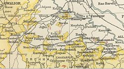
Dhurwai State in the Imperial Gazetteer of India
CapitalDhurwai 25°19′N79°03′E / 25.317°N 79.050°E / 25.317; 79.050
Area 
 1941
47 km2 (18 sq mi)
Population 
 1941
2423
History
History 
 Established
1690
1950
Succeeded by
India Flag of India.svg

Dhurwai was a princely state in India during the British Raj. It was one of the Hasht-Bhaiya Jagirs, under the Bundelkhand Agency of British India. Its capital was the town of Dhurwai, with a population of 777 in 1901. [1] Today it is part of Jhansi District, in the state of Uttar Pradesh. Dhurwai was administered by the native ruler, who was addressed as Indian Prince by the British authorities.

Contents

History

Dhurwai State was founded in the Bundelkhand region in 1812 by a descendant of the royal family of Orchha Diwan Rai Singh of Baragaon near Jhansi. He had 8 sons who were granted Jagirs, including Dhurwai, Bijna, and Tori Fatehpur. [2]

The state was located on the eastern part of Jhansi Province, bounded by the British United Provinces of Agra and Oudh on all sides except on the east where it shared a border with the states of Bijna and Tori Fatehpur. In 1823 Diwan Budh Singh was granted a sanad by the British authorities. About a century later the Diwan of Dhurwai was one of the original constituents of the Chamber of Princes, an institution established in 1920. [3] [4] After Indian independence, on 1 January 1950, Dhurwai acceded to the Indian Union and was merged into the Indian state of Vindhya Pradesh with the other Hasht-Bhaiya Jagirs.

Rulers

See also

Related Research Articles

<span class="mw-page-title-main">Bundelkhand</span> Geographical and cultural region in central India

Bundelkhand is a geographical and cultural region and a proposed state and also a mountain range in central & North India. The hilly region is now divided between the states of Uttar Pradesh and Madhya Pradesh, with the larger portion lying in the latter state.

<span class="mw-page-title-main">Vindhya Pradesh</span> Former State of India

Vindhya Pradesh was a former state of India. It occupied an area of 61,131.5 km2. It was created in 1948 as Union of Baghelkhand and Bundelkhand States, shortly after Indian independence, from the territories of the princely states in the eastern portion of the former Central India Agency. It was named as Vindhya Pradesh on 25 January 1950 after the Vindhya Range, which runs through the centre of the province. The capital of the state was the former princely state of Rewa. It lays between Uttar Pradesh to the north and Madhya Pradesh to the south, and the enclave of Datia, which lay a short distance to the west, was surrounded by the state of Madhya Bharat.

<span class="mw-page-title-main">Chhatarpur</span> City in Madhya Pradesh, India

Chhatarpur is a city and a municipality in Chhatarpur district in the state of Madhya Pradesh, India. It is the administrative headquarters of Chhatarpur District. Chhatarpur is a city and a municipality in Chhatarpur district in the state of Madhya Pradesh, India. It is the administrative headquarters of Chhatarpur District.

<span class="mw-page-title-main">Central India Agency</span> Agency of princely states in India

The Central India Agency was created in 1854, by amalgamating the Western Malwa Agency with other smaller political offices which formerly reported to the Governor-General of India. The agency was overseen by a political agent who maintained British relations with the princely states and influence over them on behalf of the Governor-General. The headquarters of the agent were at Indore.

Satna is a city in the Indian state of Madhya Pradesh. It serves as the headquarters of Satna district. It is 7th largest city and 8th most populous city of the state. The city is 500 km east of the state capital Bhopal. The city is distributed over a land area of 111.9 square kilometres.

<span class="mw-page-title-main">Bundelkhand Agency</span>

The Bundelkhand Agency was a political agency of the British Raj, managing the relations of the British government with the protected princely states of the Bundelkhand region.

<span class="mw-page-title-main">Maihar State</span> Princely state of the British Raj

Maihar State was a princely state in India during the British Raj, located in what is today Madhya Pradesh, central India. The state had an area of 1,050 square kilometres (407 sq mi), and a population of 63,702 in 1901. The state, which was watered by the Tons River, consists mainly of alluvial soil covering sandstone, and is fertile except in the hilly district of the south. A large area was under forest, the produce of which provided a small export trade.

<span class="mw-page-title-main">Datia State</span> Princely state of India

Datia State was a princely state in subsidiary alliance with British India.

<span class="mw-page-title-main">Orchha State</span> Princely state of India

Orchha State was a kingdom situated in the Bundelkhand region and later a princely state in British India. The state was ruled by Bundela clan of Rajputs. It was located within what is now the state of Madhya Pradesh.

<span class="mw-page-title-main">Paldeo</span>

Paldeo, also spelt 'Paldev', was a princely estate (Jagir) in India during the British Raj. It was under the Bundelkhand Agency of the Central India Agency until 1896 when it was transferred to the Baghelkhand Agency. In 1931 it was transferred back to the Bundelkhand Agency. It had an area of 52 square miles. In 1940 its population was 9,820 distributed in 18 villages. Paldeo Estate was merged into the Indian state of Vindhya Pradesh in 1948.

<span class="mw-page-title-main">Khaniadhana State</span> Indian Princely State

Khaniadhana or Khaniyadhana was a princely state of British India ruled by the Judev dynasty of Bundela Rajputs. The capital of the State was Khaniadhana. It was part of the Bundelkhand Agency and later the Central India Agency.

<span class="mw-page-title-main">Chhatarpur State</span> Princely state of India

Chhatarpur was one of the princely states of India during the period of the British Raj. The state was founded in 1785 and its capital was located in Chhatarpur, Madhya Pradesh.

<span class="mw-page-title-main">Panna State</span> Princely state of India

Panna State was a princely state of colonial India, located in modern Panna district of Madhya Pradesh.

<span class="mw-page-title-main">Hasht-Bhaiya</span>

The Hasht-Bhaiya (e)states were a group of jagirs of Central India during the period of the British Raj.

<span class="mw-page-title-main">Tori Fatehpur</span>

Tori Fatehpur, also known as Tori, was a princely state in India during the British Raj. It was one of the Hasht-Bhaiya Jagirs, under the Bundelkhand Agency of British India. Today it is part of Jhansi District in the state of Uttar Pradesh.

Samthar State was a princely state established in 1735 by Ranjit Singh in India during the British Raj. The state was administered as part of the Bundelkhand Agency of Central India. The state was ruled by Gujars and was the only princely state ruled by a Gujar dynasty entitled to a gun salute. Its capital, known then as Samshergarh, is located in a level plain in the Bundelkhand region crossed by the Pahuj and the Betwa Rivers.

<span class="mw-page-title-main">Taraon State</span>

Taraon, also spelt Tarrauhan,Tarahwan,and Tarahuhān, was a jagir in India during the British Raj. It had an area of 67 square miles and its population was distributed in 13 villages. The capital of the state was in Pathraundi, located about 1.5 km from Karwi railway station of the Great Indian Peninsula Railway.

<span class="mw-page-title-main">Jigni State</span>

Jigni State was a princely state of the Bundelkhand Agency of the British Raj. It was a small Sanad state of about 82.87 km2 with a population of 4,297 inhabitants in 1901. The state was surrounded by the Hamirpur and Jhansi districts of the United Provinces.

Hansari was a village of Babina Block in Jhansi district, now evolved as a suburb of Jhansi District, Uttar Pradesh, India.

References

  1. P. K. Bhattacharyya, Historical Geography of Madhya Pradesh from Early Records, p. 52
  2. Great Britain India Office. The Imperial Gazetteer of India. Oxford: Clarendon Press, 1908
  3. Imperial Gazetteer of India, v. 11, p. 339.
  4. Sir Roper Lethbridge, The Golden Book of India: A Genealogical and Biographical Dictionary, p. 124

25°19′N79°03′E / 25.317°N 79.050°E / 25.317; 79.050