Bhopal Agency

Last updated

Bhopal Agency
Agency of British India
1818–1947 Flag of India.svg
Location of Bhopal Agency Central India Agency 1909.jpg
Location of Bhopal Agency
Map of the Central India Agency with the Bhopal Agency in its central sector
History
  Established1818
   Accession to the Indian Union 1947
Area
  1901 30,181 km2(11,653 sq mi)
Population
  1901 1,157,697 
Density 38.4 /km2  (99.3 /sq mi)

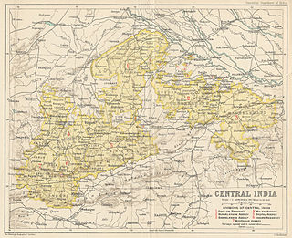
The Bhopal Agency was a section of British India's colonial Central India Agency, a British political unit which managed the relations of the British with a number of autonomous princely states existing outside British India. [1]

Central India Agency

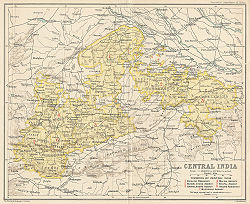
The Central India Agency was created in 1854, by amalgamating the Western Malwa Agency with other smaller political offices which formerly reported to the Governor-General of India. The agency was overseen by a political agent who maintained British relations with the princely states and influence over them on behalf of the Governor-General. The headquarters of the agent were at Indore.

Princely state Type of vassal state

A princely state, also called native state, feudatory state or Indian state, was a vassal state under a local or regional ruler in a subsidiary alliance with the British Raj. Though the history of the princely states of the subcontinent dates from at least the classical period of Indian history, the predominant usage of the term princely state specifically refers to a semi-sovereign principality on the Indian subcontinent during the British Raj that was not directly governed by the British, but rather by a local ruler, subject to a form of indirect rule on some matters. In actual fact, the imprecise doctrine of paramountcy allowed the government of British India to interfere in the internal affairs of princely states individually or collectively and issue edicts that applied to all of India when it deemed it necessary.

Contents

History

The Agency was formed in 1818 at the conclusion of the Third Anglo-Maratha War, [2] and covered the princely states of Bhopal (largest and eponymous), Khilchipur, Kurwai, Narsingarh, Muhammadgarh, Pathari and Rajgarh surrounding Bhopal, as well as the districts of Bhilsa and Isagarh, which belonged to the Gwalior State and also the district of Sironj, which belonged to Tonk State in Rajputana.

Third Anglo-Maratha War conflict between the British East India Company and the Maratha Empire in India

The Third Anglo-Maratha War (1817–1818) was the final and decisive conflict between the British East India Company (EIC) and the Maratha Empire in India. The war left the Company in control of most of India. It began with an invasion of the Maratha territory by British East India Company troops, the largest such British controlled force massed in India. The troops were led by the Governor General Hastings supported by a force under General Thomas Hislop. Operations began against the Pindaris, a band of Muslim mercenaries and Marathas from central India.

Bhopal State

Bhopal State was a tributary state in 18th-century India, a princely salute state with 19-gun salute in a subsidiary alliance with British India from 1818 to 1947, and an independent state from 1947 to 1949. Islamnagar was founded and served as the State's first capital, which was later shifted to the city of Bhopal.

Khilchipur city in Madhya Pradesh, India

Khilchipur is a town and a nagar panchayat in Rajgarh district in the Indian state of Madhya Pradesh.

The head of the Agency was appointed by the British Governor-General of India. In 1854 the Bhopal Agency became part of the newly created Central India Agency. [2] In 1895 the Gwalior districts of Bhilsa and Isagarh were transferred from Bhopal Agency to Gwalior Residency. In 1931 the princely states of Dewas Senior and Dewas Junior were added to the agency and in 1933 the state of Makrai was transferred from the Central Provinces and Berar.

Governor-General of India position

The Governor-General of India was originally the head of the British administration in India and, later, after Indian independence in 1947, the representative of the Indian head of state. The office was created in 1773, with the title of Governor-General of the Presidency of Fort William. The officer had direct control only over Fort William, but supervised other East India Company officials in India. Complete authority over all of British India was granted in 1833, and the official came to be known as the "Governor-General of India".

Gwalior Residency

Gwalior Residency was a political office in the British Indian Empire, which existed from 1782 until the British withdrawal from India in 1947.

Makrai village in Madhya Pradesh, India

Makrai is a village in the Harda district of Madhya Pradesh, India. The village was the headquarters of the Makrai princely state during the British Raj.

Bhopal Agency ceased to exist at the stroke of midnight on August 15, 1947 when British India became independent, and all treaty relations between the princely states and the British ceased to exist. After the departure of the British, the rulers of these states all acceded to the Dominion of India, and all but Bhopal were incorporated into the new state of Madhya Bharat, while Bhopal became a Chief Commissioner's Province. Madhya Bharat and Bhopal were merged into Madhya Pradesh state on November 1, 1956.

Instrument of Accession Treaty for princely states to join India or Pakistan

The Instrument of Accession was a legal document first introduced by the Government of India Act 1935 and used in 1947 to enable each of the rulers of the princely states under British paramountcy to join one of the new dominions of India or Pakistan created by the Partition of British India.

Dominion of India Period of Indian history

India was an independent dominion in the British Commonwealth of Nations with King George VI as the head of state between gaining independence from the United Kingdom on 15 August 1947 and the proclamation of a republic on 26 January 1950. It was created by the Indian Independence Act 1947 and was transformed into the Republic of India by the promulgation of the Constitution of India in 1950.

Madhya Bharat former country

Madhya Bharat, also known as Malwa Union, was an Indian state in west-central India, created on 28 May 1948 from twenty-five princely states which until 1947 had been part of the Central India Agency, with Jiwajirao Scindia as its Rajpramukh.

States and territories

Until 1931 the agency included nine princely states, as well as a number of estates ruled by Thakurs and other minor territories.

Princely states

Four Salute states, by precedence :

Narsinghgarh State princely state of the British Raj

Narsinghgarh State is a former princely state of the British Raj in India. It formed an enclave within Rajgarh State and was placed administratively under the Bhopal Agency subdivision of the Central India Agency. The state covered an area of 1,920 square kilometres (740 sq mi) and had a population of 92,093 in 1901.

Rajgarh State

Rajgarh State was a Rajput princely state in India, named after its capital Rajgarh, Madhya Pradesh. It was part of the colonial Bhopal Agency of the Central India Agency during the British Raj.

Khilchipur State

Khilchipur State was a princely state in India. The seat was in Khilchipur. It had an area of 710 square kilometres (273 sq mi), and a population of 31,143 in 1901. Its estimated revenue in 1911 was 70000 rupees, and it paid a yearly tribute to the Maharaja Scindia of Gwalior of 700 rupees.

Non-salute states, alphabetically :

Related Research Articles

Central Provinces and Berar

The Central Provinces and Berar was a province of British India and later the Dominion of India which existed from 1936 to 1950. It was formed by the merger of the Central Provinces with the province of Berar, which was territory leased by the British from the Hyderabad State. Through an agreement signed on 5 November 1902, 6th Nizam Mahbub Ali Khan, Asaf Jah VI leased Berar permanently to the British for an annual payment of 25 lakhs Rupees. Lord Curzon decided to merge Berar with the Central Provinces, and this was proclaimed on 17 September 1903.

Bhopawar Agency

Bhopawar Agency was a sub-agency of the Central India Agency in British India with the headquarters at the town of Bhopawar, so the name. Bhopawar Agency was created in 1882 from a number of princely states in the Western Nimar and Southern Malwa regions of Central India belonging to the former Bhil Agency and Bhil Sub-agency with the capitals at Bhopawar and Manpur. The agency was named after Bhopawar, a village in Sardarpur tehsil, Dhar District of present-day Madhya Pradesh state. Manpur remained a strictly British territory.

Rajgarh district District of Madhya Pradesh in India

Rajgarh district is a District of Madhya Pradesh state in central India. The city of Rajgarh is the administrative headquarters of the district.

Vidisha District is a district of Madhya Pradesh state in central India. The city of Vidisha as the administrative headquarters of the district.

Malwa Agency was an administrative section of British India's Central India Agency. The headquarters of the political agent was at Mandsaur (Mandasor) / Neemuch (Nimach). The other chief towns of the region were : Ratlam and Jaora.

Punjab States Agency

The Punjab States Agency was a political office of the British Indian Empire. The agency was created in the 1930s, on the model of the Central India Agency and Rajputana Agency, and dealt with forty princely states in northwest India formerly dealt with by the British province of the Punjab.

Bundelkhand Agency

The Bundelkhand Agency was a political agency of the British Raj, managing the relations of the British government with the protected princely states of the Bundelkhand region.

Mohammadgarh State

Mohammadgarh State, also spelt as 'Muhammadgarh', was a former princely state in Central India, under the Bhopal Agency during the British Raj. It was situated in the Malwa Plateau. The state had an area of 29 square miles (75 km2), and a population of 2,944. Its headquarters were at Mohammadgarh town.

Khaniadhana State

Khaniadhana or Khaniyadhana was a princely state of British India ruled by the Judev dynasty of Bundela Rajputs. The capital of the State was Khaniadhana. It was part of the Bundelkhand Agency and later the Central India Agency.

Makrai State

Makrai State was a princely state in India during the time of the British Raj. The seat was in Makrai.

Jhabua State

Jhabua State was one of the princely states of India during the period of the British Raj. It had its capital in Jhabua town. Most of the territory of the princely state was inhabited by the Bhil people, who constituted a majority of the population. Umarkot was a thikana or vassal state of Jhabua.

Rao is one of the cognate Hindi variations of the title Raja(h), used as equivalent royal style in certain princely states, notably of former British India.

References

  1. Great Britain India Office. The Imperial Gazetteer of India . Oxford: Clarendon Press, 1908.
  2. 1 2 Wikisource-logo.svg Chisholm, Hugh, ed. (1911). "Bhopal". Encyclopædia Britannica . 3 (11th ed.). Cambridge University Press. p. 846.

Coordinates: 23°15′00″N77°56′13″E / 23.2500°N 77.9369°E / 23.2500; 77.9369