Madhya Pradesh is a state in central India. Its capital is Bhopal, and the largest city is Indore, with Jabalpur, Gwalior, Ujjain and Sagar being the other major cities. Nicknamed the "Heart of India" due to its geographical location, Madhya Pradesh is the second largest Indian state by area and the fifth largest state by population with over 75 million residents. It borders the states of Uttar Pradesh to the northeast, Chhattisgarh to the southeast, Maharashtra to the south, Gujarat to the west, and Rajasthan to the northwest. Its total area is 308,252 km2. Before 2000, when Chhattisgarh was a part of Madhya Pradesh, Madhya Pradesh was the largest state in India and the distance between the two furthest points inside the state, Singoli and Konta, was 1500 km. Konta is presently in Sukma district of Chhattisgarh state.

The Yamuna, also known as the Jumna or Jamuna, is the second largest tributary river of the Ganges (Ganga) and the longest tributary in India. Originating from the Yamunotri Glacier at a height of 6,387 metres (20,955 ft) on the southwestern slopes of Banderpooch peaks of the Lower Himalaya in Uttarakhand, it travels a total length of 1,376 kilometres (855 mi) and has a drainage system of 366,223 square kilometres (141,399 sq mi), 40.2% of the entire Ganges Basin. It merges with the Ganges at Triveni Sangam, Prayagraj (Allahabad), which is a site of the Kumbh Mela, a Hindu festival held every 12 years.

The Buckingham Canal is a 796 kilometres (494.6 mi) long fresh water navigation canal, that parallels the Coromandel Coast of South India from Kakinada in the East Godavari district of Andhra Pradesh to Villupuram District in Tamil Nadu. The canal connects most of the natural backwaters along the coast to Chennai (Madras) port. It was constructed during British Rule, and was an important waterway during the late nineteenth and early twentieth centuries.

Pachmarhi is a hill station in Hoshangabad district of Madhya Pradesh state of central India. It has been the location of a cantonment since British Raj. It is widely known as Satpura ki Rani, situated at a height of 1067 m in a valley of the Satpura Range in Hoshangabad district. Dhupgarh, the highest point (1,352 m) in Madhya Pradesh and the Satpura range, is located here. It is a part of Pachmarhi Biosphere Reserve.

The Bhoj Wetland consists of two lakes located in the city of Bhopal, the capital of the central Indian state of Madhya Pradesh. The two lakes are the Bhojtal & the Lower Lake, which lie to the west of the city center. The Bhojtal has an area of 31 km², and drains a catchment or watershed of 361 km². The watershed of the Bhojtal is mostly rural, with some urbanized areas around its eastern end. The lower lake has an area of 1.29 km². Its catchment is 9.6 km² and is mostly urbanized; the Lower Lake also receives subsurface seepage from the Bhojtal.

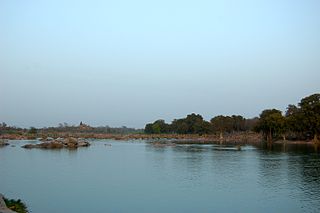
The Chambal River is a tributary of the Yamuna River in central India, and thus forms part of the greater Gangetic drainage system. The river flows north-northeast through Madhya Pradesh, running for a time through Rajasthan, then forming the boundary between Rajasthan and Madhya Pradesh before turning southeast to join the Yamuna in Uttar Pradesh state.
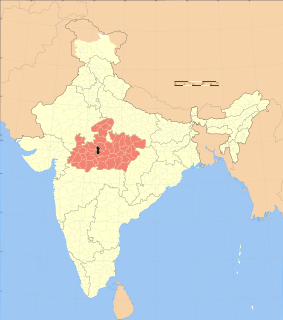
Bhopal District is a district of Madhya Pradesh state in central India. The city of Bhopal serves as its administrative headquarters. The district is part of Bhopal Division.

Mahanoy Creek is a 51.6-mile-long (83.0 km) tributary of the Susquehanna River in Northumberland and Schuylkill counties, Pennsylvania. There are at least 35 sources of acid mine drainage in the creek's watershed. Anthracite was mined in the upper part of the Mahanoy Creek watershed in the 19th and 20th centuries. Mahanoy Creek's tributaries include Schwaben Creek, Zerbe Run, Little Mahanoy Creek, Shenandoah Creek, and North Mahanoy Creek. Little Mahanoy Creek and Schwaben Creek are two streams in the watershed that are unaffected by acid mine drainage. Schwaben Creek has a higher number and diversity of fish species than the main stem.
The Bhadbhada dam is a set of 11 sluice gates at the south-east corner of Upper lake in Bhopal. It was constructed in 1965. The gates are used to control the outflow of water from the lake to Kaliasote river, and are usually opened only when the city receives heavy rainfall during the monsoon season. It has a full tank level of 1666.80 feet.
Buddha Nullah or Buddha Nala is a seasonal water stream, which runs through the Malwa region of Punjab, India, and after passing through highly populated Ludhiana district, Punjab, India, it drains into Sutlej River, a tributary of the Indus river. Today it has also become a major source of pollution in the region as well the main Sutlej river, as it get polluted after entering the highly populated and industrialized Ludhiana city, turning it into an open drain. Also, since large area in south-western Punjab solely depend on the canal water for irrigation, and water from Buddha Nullah enters various canals after Harike waterworks near Firozpur, thus affecting far-reaching areas such as Malout, Zira, upper Lambi, while the areas being fed by Sirhind feeder, are the most-affected by its pollution.

Lai Nullah, commonly called Nullah Lai, is a rain water fed natural stream flowing through the city of Rawalpindi. Every monsoon season the stream floods after being fed by its catchment basin in the Margalla Hills bordering Islamabad, Pakistan.

Islamnagar is a panchayat village in the Bhopal district of Madhya Pradesh, India. It is located in the Huzur tehsil and the Phanda block.
Mangalgarh is a panchayat village in the Berasia tehsil of Bhopal district, Madhya Pradesh, India.

The Halali reservoir is a reservoir in the Raisen district of Madhya Pradesh, India. It is built on the Halali River, and lies 40 km away from the state capital Bhopal.

The Kolar is a right bank tributary of the Narmada River. It flows for a total length of 101 km, all of which is in the state of Madhya Pradesh.
Sair Sapata is a tourism and entertainment complex situated on the banks of the Upper Lake in Bhopal. Developed by the Madhya Pradesh State Tourism Development Corporation, it is spread over an area of 24.56 acres, and was inaugurated on 29 September 2011 by State Chief Minister. Aimed at promoting tourism, the complex has attractions like musical fountain, two acres of children’s play area, toy train and a suspension bridge, among other things.
Kolu Khedi is a village in the Bhopal district of Madhya Pradesh, India. It is located in the Huzur tehsil and the Phanda block, beside Upper Lake. The nearest railway station is Bakanian Bhaunr.
Bhauri is a village in the Bhopal district of Madhya Pradesh, India. It is located in the Huzur tehsil and the Phanda block. Bhauri has been included in Bhopal Municipal Corporation in 2015 by Gazette Notification of Government of Madhya Pradesh. The IISER Bhopal is located in Bhauri, beside the Bhopal Bypass Road. School of Planning and Architecture (SPA) Bhopal, an Institute of National Importance under Ministry of Human Resource Development, is located in Bhauri village. SPA is accessed by Neelbad Road from Bhopal Bypass. The road is under construction. Madhya Pradesh Police Academy is also situated in Bhauri village.