Ajaigarh or Ajaygarh is a town and a nagar panchayat in the Panna District of Madhya Pradesh state in central India.

The Central Provinces and Berar was a province of British India and later the Dominion of India which existed from 1903 to 1950. It was formed by the merger of the Central Provinces with the province of Berar, which was territory leased by the British from the Hyderabad State. Through an agreement signed on 5 November 1902, 6th Nizam Mahbub Ali Khan, Asaf Jah VI leased Berar permanently to the British for an annual payment of 25 lakhs rupees. Lord Curzon decided to merge Berar with the Central Provinces, and this was proclaimed on 17 September 1903.

Chhatarpur is a city and a municipality in Chhatarpur district in the state of Madhya Pradesh, India. It is the administrative headquarters of Chhatarpur District. Chhatarpur is a city and a municipality in Chhatarpur district in the state of Madhya Pradesh, India. It is the administrative headquarters of Chhatarpur District.

The Central India Agency was created in 1854, by amalgamating the Western Malwa Agency with other smaller political offices which formerly reported to the Governor-General of India. The agency was overseen by a political agent who maintained relations of the Government of India with the princely states and influence over them on behalf of the Governor-General. The headquarters of the agent were at Indore.

Datia is the district headquarter of the Datia District in north central Madhya Pradesh,a state of Central India. It is an ancient town, mentioned in the Mahabharata ruled by King Dantavakra. The city is 78 km from Gwalior, 325 km south of New Delhi and 344 km north of Bhopal. About 18 km from Datia is Sonagiri, a sacred Jain hill. Datia is also about 31 km from Jhansi and 52 km from Orchha. The nearest airport is at Gwalior. It was formerly the seat of the eponymous princely state in the British Raj. Datia is situated near Gwalior and on the border with Uttar Pradesh.

Korea State, currently spelt as Koriya, was a princely state of the British Empire of India. After Indian independence in 1947, the ruler of Korea acceded to the Union of India on 1 January 1948, and Koriya was made part of Surguja District of Central Provinces and Berar province. In January 1950, "Central Provinces and Berar" province was renamed Madhya Pradesh state. After November 2000, Korea and the former princely state of Changbhakar became Koriya district of Chhattisgarh state.
Satna is a city in the Indian state of Madhya Pradesh. It serves as the headquarters of Satna district. It is 7th largest city and 8th most populous city of the state. The city is 500 km east of the state capital Bhopal. The city is distributed over a land area of 111.9 square kilometres.
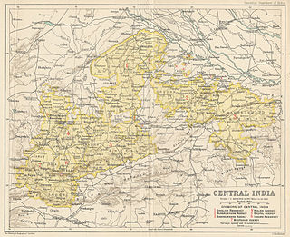
The Bhopal Agency was a section of British India's colonial Central India Agency, a British political unit which managed the relations of the British with a number of autonomous princely states existing outside British India.
The Eastern States Agency was an agency or grouping of princely states in eastern India, during the latter years of the Indian Empire. It was created in 1933, by the unification of the former Chhattisgarh States Agency and the Orissa States Agency; the agencies remained intact within the grouping. In 1936, the Bengal States Agency was added.
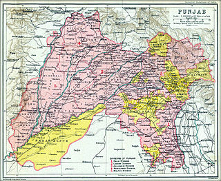
The Punjab States Agency was an agency of the British Raj. The agency was created in 1921, on the model of the Central India Agency and Rajputana Agency, and dealt with forty princely states in northwest India formerly dealt with by the Province of Punjab.

Rewa State, also known as Rewah, was a Rajput princely state of India, surrounding its eponymous capital, the town of Rewa.

Bastar state was a princely state in India during the British Raj. It was founded in the early 14th century by Annamaraja, a brother of the last ruler of the Kakatiya dynasty, Prataparudra II.
Sirali is a town in the Harda district, Madhya Pradesh, India. The town has an estimated population of 15,507 people, and life revolves around the Machak River and Ghonghai River, the life line of the town. Sirali is well connected with the district by road. The nearest Railway station is Harda and Khirkiya, 30 km distant. Sirali is the major town surrounded with 50 villages. This was coming under the Gond King's Kingdom, well known as Makrai state. Sirali town is well developed in the last few years with Nationaized banks, and Internet. In Education, Sirali has schools till higher secondary. Two colleges are also here, one is Pvt. Satpura Valley College and the other one is Govt arts and commerce college. It has also the police station which is situated near shiv temple. Timber depot from M.P. Forest department. Weekly Hat Bajar (Sunday) is also organised here. Diwali, Holi, Rakshabandhan, Eid are the major festivals celebrated here.
Dewas State was a territory within Central India, which was the seat of two Maratha princely states during the British Raj. After the Maratha conquest of Central India, Dewas was divided into two states - Dewas Junior ruled by Jivaji Rao Puar and Dewas Senior ruled by Tukoji Rao Puar. On 12 December 1818, the 2 Dewas States became British protectorates.

Chhatarpur was one of the princely states of India during the period of the British Raj. The state was founded in 1785 and its capital was located in Chhatarpur, Madhya Pradesh.

Udaipur State was one of the princely states of India during the period of the British Raj. The town of Dharamjaigarh was the former state's capital.
The Nerbudda Division, named after the Narmada River (Nerbudda), was a former administrative division of the Central Provinces of British India. It encompassed a good part of the Narmada River basin in the eastern part of present-day Madhya Pradesh state of India. The Nerbudda Division had an area of 47,609.2 km2 with a population of 1,785,008 in 1901.

Surguja State was one of the main princely states of Central India during the period of the British Raj, even though it was not entitled to any gun salute. Formerly it was placed under the Central India Agency, but in 1905 it was transferred to the Eastern States Agency.

Makrai State was a princely state in India during the time of the British Raj. The seat was in Makrai.
Kenud is a village of the Punasa tehsil of Khandwa district, in Madhya Pradesh state, India. The village is almost three hundred years old. Which was founded around 1700 AD by Joraji Singh Badal. Most of the people of the village depend on agriculture, workers and youth are dependent on the nearby city of Mundi and Shree Singaji Thermal Power Project for employment.

