Kamta-Rajaula State कामता-राजुला रियासत | |||||||
---|---|---|---|---|---|---|---|
Princely Estate (Jagir) | |||||||
1812–1948 | |||||||
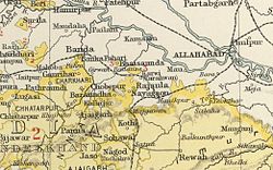
The area of the Chaube Jagirs in the Imperial Gazetteer of India | |||||||
Area | |||||||
• 1901 | 34 km2 (13 sq mi) | ||||||
Population | |||||||
• 1901 | 1,232 | ||||||
History | |||||||
History | |||||||
• Established | 1812 | ||||||
1948 | |||||||
|
Kamta-Rajaula was a princely state in India during the British Raj.
It was one of the Chaube Jagirs, part of the Bagelkhand Agency which was merged into the Indian state of Vindhya Pradesh in 1948.
Kamta-Rajaula was a place of pilgrimage, for according to legend it was one of the places where Rama had been. [1] The capital was the village of Rajaula, located at 15 km from Karwi railway station.
The rulers of Kamta-Rajaula were titled 'Rao'. [2] [3]
Vindhya Pradesh was a former state of India. It occupied an area of 23,603 sq. miles. It was created in 1948 as Union of Baghelkhand and Bundelkhand States, shortly after Indian independence, from the territories of the princely states in the eastern portion of the former Central India Agency. It was named as Vindhya Pradesh on 25 January 1950 after the Vindhya Range, which runs through the centre of the province. The capital of the state was firstly Singrauli till 1953, secondly Rewa from 1953 onwards. It lays between Uttar Pradesh to the north and Madhya Pradesh to the south, and the enclave of Datia, which lay a short distance to the west, was surrounded by the state of Madhya Bharat.
Bagelkhand or Baghelkhand is a region and also a mountain range in central India that covers the northeastern regions of Madhya Pradesh and a small area of southeastern Uttar Pradesh.
The Central India Agency was created in 1854, by amalgamating the Western Malwa Agency with other smaller political offices which formerly reported to the Governor-General of India. The agency was overseen by a political agent who maintained British relations with the princely states and influence over them on behalf of the Governor-General. The headquarters of the agent were at Indore.
The Bagelkhand Agency was a British political unit which managed the relations of the British with a number of autonomous princely states existing outside British India, namely Rewa and 11 minor states, of which the most prominent were Maihar, Nagod and Sohawal. Other principalities included Jaso, Kothi, Baraundha as well as the Kalinjar Chaubes, consisting of the princely estates of Paldeo, Kamta-Rajaula, Taraon, Pahra and Bhaisaunda.
Baraundha was a princely state of colonial India, located in modern Satna district of Madhya Pradesh. Although historically far larger, at the time of Indian independence in 1950, it was a saluted state of 9 guns.
Bhor State was one of the 9-gun salute Maratha princely states of British India. It was the only state belonging to the Poona Agency under the Bombay Presidency, which became later part of the Deccan States Agency. Along with Akkalkot State, Aundh State, Phaltan State, Nimsod State and Jath State, it was one of the Satara Jagirs.
Sakti State was one of the princely states of India during the British Raj. It belonged to the Chhattisgarh States Agency, which later became the Eastern States Agency.
Paldeo, also spelt 'Paldev', was a princely estate (Jagir) in India during the British Raj. It was under the Bundelkhand Agency of the Central India Agency until 1896 when it was transferred to the Baghelkhand Agency. In 1931 it was transferred back to the Bundelkhand Agency. It had an area of 52 square miles. In 1940 its population was 9,820 distributed in 18 villages. Paldeo Estate was merged into the Indian state of Vindhya Pradesh in 1948.
Indore State, also known as Holkar State, was a royal state in India. Its rulers belonged to the Holkar dynasty. Indore was a 19-gun salute Maratha princely state during the British rule in India.
Hindol State was one of the princely states of India during the period of the British Raj. Its former territory is now part of Dhenkanal district. The state's former capital was the town of Hindol, Odisha. Until 1947, it was not part of British India but was subject to the suzerainty of the British crown, under the Orissa States Agency.
The Chhota Udaipur State or 'Princely State of Chhota Udaipur', was a princely state with its capital in Chhota Udaipur during the era of British India. The last ruler of Chhota Udaipur State signed the accession to join the Indian Union in 1948. Chhota Udaipur shares a history with Devgadh Baria and Rajpipla as one of the three princely states of eastern Gujarat.
Baudh State, also known as Boudh State, was one of the princely states of India during the period of the British Raj. It was recognized as a state in 1874 and had its capital in Boudh town. Its last ruler signed the accession to the Indian Union on 1 January 1948.
Udaipur State was one of the princely states of India during the period of the British Raj. The town of Dharamjaigarh was the former state's capital.
Nagod State was a princely state of colonial India, located in modern Satna district of Madhya Pradesh. The state was known as 'Unchahara' from the name of Unchehara its original capital until the 18th century.
The Chaube Jagirs, also known as 'Kalinjar Chaubes', jagir states were a group of five feudatory states of Central India during the period of the British Raj. They were a British protectorate from 1823 to 1947 and belonged to the Bagelkhand Agency. Their last rulers acceded to India in 1948.
Tripura State, also known as Hill Tipperah, was a princely state in India during the period of the British Raj and for some two years after the departure of the British. Its rulers belonged to the Manikya dynasty and until August 1947 the state was in a subsidiary alliance, from which it was released by the Indian Independence Act 1947. The state acceded to the newly independent Indian Union on 13 August 1947, and subsequently merged into the Indian Union in October 1949.
Bhaisunda, also spelt 'Bhaisaunda', was a princely state in India during the British Raj.
Tarrauhan, also spelt 'Tarahwan' and 'Tarahuhān', was a jagir in India during the British Raj. It had an area of 67 square miles and its population was distributed in 13 villages. The capital of the state was in Pathraundi, located about 1.5 km from Karwi railway station of the Great Indian Peninsula Railway.
Beri State was a princely state of the Bundelkhand Agency of the British Raj. It was a small Sanad state of about 82.87 km2 with a population of 4,297 inhabitants in 1901. Its capital was at Beri, a small town —2,387 inhabitants in 1901— located by the Betwa River in modern Hamirpur district of Uttar Pradesh, about 30 km from Hamirpur town.
Coordinates: 25°11′N80°51′E / 25.183°N 80.850°E