
The Central Provinces and Berar was a province of British India and later the Dominion of India which existed from 1903 to 1950. It was formed by the merger of the Central Provinces with the province of Berar, which was territory leased by the British from the Hyderabad State. Through an agreement signed on 5 November 1902, 6th Nizam Mahbub Ali Khan, Asaf Jah VI leased Berar permanently to the British for an annual payment of 25 lakhs rupees. Lord Curzon decided to merge Berar with the Central Provinces, and this was proclaimed on 17 September 1903.

Vindhya Pradesh was a former state of India. It occupied an area of 61,131.5 km2. It was created in 1948 as Union of Baghelkhand and Bundelkhand States, shortly after Indian independence, from the territories of the princely states in the eastern portion of the former Central India Agency. It was named as Vindhya Pradesh on 25 January 1950 after the Vindhya Range, which runs through the centre of the province. The capital of the state was the former princely state of Rewa. It lay between Uttar Pradesh to the north and Madhya Pradesh to the south, and the enclave of Datia, which lay a short distance to the west, was surrounded by the state of Madhya Bharat.

Bagelkhand or Baghelkhand is a proposed state and a mountain range in central India that covers the northeastern regions of Madhya Pradesh and a small area of southeastern Uttar Pradesh.

The Central India Agency was created in 1854, by amalgamating the Western Malwa Agency with other smaller political offices which formerly reported to the Governor-General of India. The agency was overseen by a political agent who maintained relations of the Government of India with the princely states and influence over them on behalf of the Governor-General. The headquarters of the agent were at Indore.
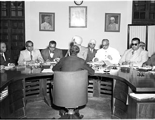
Rajpramukh was an administrative title in India which existed from India's independence in 1947 until 1956. Rajpramukhs were the appointed governors of certain Indian provinces and states.

Rewa district is a district of the Madhya Pradesh state in central India. The city of Rewa is the district headquarter. Rewa is sometimes called the "Land of White Tigers", as the first White Tiger was discovered here in 1951 by the Maharaja of the province, Martand Singh, in the nearby jungle of Govindgarh. Rewa was the capital city of a former state, Vindhya Pradesh.

Satna is a city in the Indian state of Madhya Pradesh. It serves as the headquarters of Satna district. It is 7th largest city and 8th most populous city of the state. The city is 500 km east of the state capital Bhopal. The city is distributed over a land area of 111.9 square kilometres.

Rewa Kantha was a political agency of British India, managing the relations of the British government's Bombay Presidency with a collection of princely states. It stretched for about 150 miles between the plain of Gujarat and the hills of Malwa, from the Tapti River to the Mahi River crossing the Rewa River, from which it takes its name.
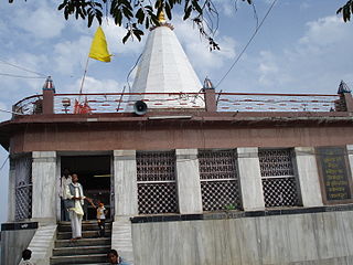
Maihar is a city in the Maihar district of the Indian state of Madhya Pradesh. It's Administrative Headquarter of Maihar District. Maihar is known for the Maa Sharda Mandir situated in the city.
The Eastern States Agency was an agency or grouping of princely states in eastern India, during the latter years of the British Raj. It was created in 1933, by the unification of the former Chhattisgarh States Agency and the Orissa States Agency; the agencies remained intact within the grouping. In 1936, the Bengal States Agency was added.

The Bundelkhand Agency was a political agency of the British Raj, managing the relations of the British government with the protected princely states of the Bundelkhand region.

Rewa State, also known as Rewah, was a Kingdom and later princely state of India, surrounding its eponymous capital, the town of Rewa.

An agency of British India was an internally autonomous or semi-autonomous unit of British India whose external affairs were governed by an agent designated by the Viceroy of India.
The Kathiawar Agency, on the Kathiawar peninsula in the western part of the Indian subcontinent, was a political unit of some 200 small princely states under the suzerainty of the Bombay Presidency of British India.

Govindgarh, the summer capital of Mahraja Rewa, is about 18 km from Rewa in Madhya Pradesh, India. The is Rewa, with an area of about 13,000 mi², was the largest princely state in the Bagelkhand Agency and the second largest in Central India Agency. The British political agent for Bagelkhand resided at Satna, on the East Indian railway. The Bagelkhand capital establish in Rewa under the Rewa Maharaja.Bagheli is the local language of the region.It's neighbouring towns are Manikawar, Gurh and Rewa.
Maihar State was a princely state in India during the British Raj, located in what is today Madhya Pradesh, central India. The state had an area of 1,050 square kilometres (407 sq mi), and a population of 63,702 in 1901. The state, which was watered by the Tons River, consists mainly of alluvial soil covering sandstone, and is fertile except in the hilly district of the south. A large area was under forest, the produce of which provided a small export trade.

The Cutch Agency was one of the agencies of British India. The appointed Political Agent looked after only one territory, that of the princely state of Cutch, which had a surface of 19,725 square kilometres (7,616 sq mi), not including the Rann of Kutch.
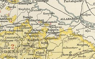
Kamta-Rajaula was a princely state in India during the British Raj.

Baroda and Gujarat States Agency was a political agency of British India, managing the relations of the British government of the Bombay Presidency with a collection of princely states.

Bhaisunda, also spelt 'Bhaisaunda', was a princely state in India during the British Raj.
