Paldeo

Last updated

Paldeo State
पालदेव रियासत
Princely Estate (Jagir)
1812–1948
Kothi-Bhaisunda map.jpg
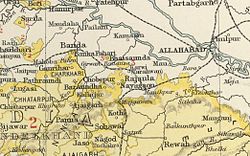
Paldeo (Nayagaon) in the Imperial Gazetteer of India
Area 
 1901
73 km2 (28 sq mi)
Population 
 1901
8598
History 
 Established
1812
1948
Succeeded by
India Flag of India.svg

Paldeo, also spelt 'Paldev', was a princely estate (Jagir) in India during the British Raj. [1] It was under the Bundelkhand Agency of the Central India Agency until 1896 when it was transferred to the Baghelkhand Agency. [2] In 1931 it was transferred back to the Bundelkhand Agency. It had an area of 52 square miles. In 1940 its population was 9,820 distributed in 18 villages. Paldeo Estate was merged into the Indian state of Vindhya Pradesh in 1948.

Contents

History

Paldeo was founded in 1812. It was one of the Chaube Jagirs. [3]

Rulers

Paldeo's rulers bore the title 'Rao'. [4]

Raos

  • 1812 - 1840 Dariao Singh (d. 1840)
  • 1840 - Nathu Ram
  • 1840 - Oct 1842 Raja Ram (d. 1842)
  • 1842 - 1865 Sheo Prasad (d. 1865)
  • 1865 - 2 Apr 1874 Mukund Singh (d. 1874)
  • 2 Apr 1874 - 1891 Anrudh Singh (b. 1837 - d. 1891) (personal style 'Rao' from 1877)
  • 1891 - 1894 Narayan Das (b. 1836 - d. 1894)
  • 16 Feb 1894 - 2 Oct 1923 Jagat Rai (b. 1865 - d. 1923)
  • 3 Oct 1923 - 1947 Shiva Prasad (b. 1908 - d. 1954)

See also

Related Research Articles

Vindhya Pradesh

Vindhya Pradesh was a former state of India. It occupied an area of 23,603 sq. miles. It was created in 1948 as Union of Baghelkhand and Bundelkhand States, shortly after Indian independence, from the territories of the princely states in the eastern portion of the former Central India Agency. It was named as Vindhya Pradesh on 25 January 1950 after the Vindhya Range, which runs through the centre of the province. The capital of the state was Rewa. It lay between Uttar Pradesh to the north and Madhya Pradesh to the south, and the enclave of Datia, which lay a short distance to the west, was surrounded by the state of Madhya Bharat.

Central India Agency

The Central India Agency was created in 1854, by amalgamating the Western Malwa Agency with other smaller political offices which formerly reported to the Governor-General of India. The agency was overseen by a political agent who maintained British relations with the princely states and influence over them on behalf of the Governor-General. The headquarters of the agent were at Indore.

Satna City in Madhya Pradesh, India

Satna is a city in the Satna district of the Indian state of Madhya Pradesh.

Bundelkhand Agency

The Bundelkhand Agency was a political agency of the British Raj, managing the relations of the British government with the protected princely states of the Bundelkhand region.

Maihar State

Maihar State was a princely state in India during the British Raj, located in what is today Madhya Pradesh, central India. The state had an area of 1,050 square kilometres (407 sq mi), and a population of 63,702 in 1901. The state, which was watered by the Tons River, consists mainly of alluvial soil covering sandstone, and is fertile except in the hilly district of the south. A large area was under forest, the produce of which provided a small export trade.

Alipura State

Alipura was a princely state in what is today the Chhatarpur District in the Indian state of Madhya Pradesh.

Baraundha

Baraundha was a princely state of colonial India, located in modern Satna district of Madhya Pradesh. Although historically far larger, at the time of Indian independence in 1950, it was a saluted state of 9 guns.

Indore State

Indore State, also known as Holkar State, was a royal state in India. Its rulers belonged to the Holkar dynasty. Indore was a 19-gun salute Maratha princely state during the British rule in India.

Jaso State

Jaso or Jassu, formerly known as Yashogarh was a princely state of the Bundelkhand Agency in British India located in present-day Nagod tehsil, Satna district, Madhya Pradesh. It was surrounded in the north, east and south by Nagod State and in the east by Ajaigarh.

Events in the year 1837 in India.

Kamta-Rajaula State

Kamta-Rajaula was a princely state in India during the British Raj.

Nagod State

Nagod State was a princely state of colonial India, located in modern Satna district of Madhya Pradesh. The state was known as 'Unchahara' from the name of Unchehara its original capital until the 18th century.

Panna State

Panna State was a princely state of colonial India, located in modern Panna district of Madhya Pradesh.

Chaube Jagirs

The Chaube Jagirs, also known as 'Kalinjar Chaubes', jagir states were a group of five feudatory states of Central India during the period of the British Raj. They were a British protectorate from 1823 to 1947 and belonged to the Bagelkhand Agency. Their last rulers acceded to India in 1948.

Bhaisunda

Bhaisunda, also spelt 'Bhaisaunda', was a princely state in India during the British Raj.

Dhurwai State

Dhurwai was a princely state in India during the British Raj. It was one of the Hasht-Bhaiya Jagirs, under the Bundelkhand Agency of British India. Its capital was the town of Dhurwai, with a population of 777 in 1901. Today it is part of Jhansi District, in the state of Uttar Pradesh. Dhurwai was administered by the native ruler, who was addressed as Indian Prince by the British authorities.

Taraon State

Taraon, also spelt 'Tarahwan' and 'Tarahuhān', was a jagir in India during the British Raj. It had an area of 67 square miles and its population was distributed in 13 villages. The capital of the state was in Pathraundi, located about 1.5 km from Karwi railway station of the Great Indian Peninsula Railway.

Pahra

Pahra was a jagir in India during the British Raj. It was under the Bundelkhand Agency of the Central India Agency until 1896 when it was transferred to the Baghelkhand Agency. It was later transferred back to the Bundelkhand Agency.

This article details events in the year 1840 in India. Occurrences include the establishment of the Bank of Bombay, and the fall of the Maqpon dynasty.

References

  1. Columbia-Lippincott Gazetteer p. 1414.
  2. Great Britain India Office. The Imperial Gazetteer of India. Oxford: Clarendon Press, 1908
  3. "History of Satna". Satna District Administration. Retrieved 18 August 2010.
  4. Indian Princely States

Coordinates: 25°06′N80°50′E / 25.100°N 80.833°E / 25.100; 80.833