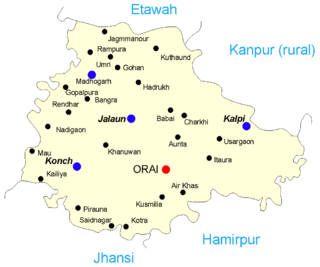
Jalaun is a city and a municipal board in Jalaun district in the Indian state of Uttar Pradesh.

Jhajjar district is one of the 22 districts of Haryana state in northern India. Carved out of Rohtak district on 15 July 1997 and with its headquarters in Jhajjar, it lies 29 kilometres (18 mi) from Delhi and had developed into an important industrial center. Other towns in the district are Bahadurgarh and Badli and Beri. Bahadurgarh is the major city of the district and state. Bahadurgarh is known as 'The City of Destiny'. Beri used to be a village fifty years ago.

Narsinghpur district is a district of Madhya Pradesh state in central India. Vindhyachal is on its northern border and the Satpura range extends along its entire length on the southern border. In the northern part, the Narmada river flows from east to west. Latitude 22º.45N 23º.15N, Longitude 78º.38E 79º.38E, Area 5125.55 Square Kilometers, 359.8 meters above sea level. The city of Narsinghpur is administrative headquarters of the district. As of 2001 Narsinghpur is the most literate district of MP.

Bhopawar Agency was a sub-agency of the Central India Agency in British India with the headquarters at the town of Bhopawar, so the name. Bhopawar Agency was created in 1882 from a number of princely states in the Western Nimar and Southern Malwa regions of Central India belonging to the former Bhil Agency and Bhil Sub-agency with the capitals at Bhopawar and Manpur. The agency was named after Bhopawar, a village in Sardarpur tehsil, Dhar District of present-day Madhya Pradesh state. Manpur remained a strictly British territory.
Dholpur District is a district of Rajasthan state in Northern India. The town of Dholpur is the district headquarters. Dholpur District is a part of Bharatpur Divisional Commissionerate. It was carved out from the erstwhile Bharatpur District on 15 April 1982.
Jobat is a city and a nagar parishad municipality in Alirajpur district in the Indian state of Madhya Pradesh.
The Bundelkhand Agency was a political agency of the British Raj, managing the relations of the British government with the protected princely states of the Bundelkhand region.
Umrain is a town in Auraiya district in the state of Uttar Pradesh, India. Umrain is one of the sub-divisional towns of Auraiya District. This township is situated to the north west of Auraiya, the district headquarters 65 km, and 21 km away from Bidhuna, another major town in the district. Airwa-Katra, Bidhuna, Harnagarpur and Usrahaar are its neighboring towns. Umrain is linked directly to Kishni and Bidhuna Road. The literacy is about 80%. In Umrain there are two famous temple Durga Mandir and Dwarikadheesh Mandir.

Alipura was a princely state in what is today the Chhatarpur District in the Indian state of Madhya Pradesh.

Chingleput district was a district in the Madras Presidency of British India. It covered the area of the present-day districts of Kanchipuram, Chengalpattu and Tiruvallur and parts of Chennai city. It was sub-divided into six taluks with a total area of 7,970 square kilometres (3,079 sq mi). The first capital was the town of Karunguzhi, with an interruption between 1825 and 1835, administrative headquarters were transferred to Kanchipuram. In 1859, the capital Saidapet, now a neighbourhood in the city of Chennai, was made the administrative headquarters of the district.

Baoni State was a princely state in India during the British Raj. It was a small sanad state, the only Muslim-ruled one in Bundelkhand Agency. Its ruler was granted the right to an 11-gun salute. The Baoni royal family claim to be descendants of the Asaf Jahi dynasty of Hyderabad, tracing its origins to Abu Bakr, the first Islamic caliph.

Chhatarpur was one of the princely states of India during the period of the British Raj. The state was founded in 1785 and its capital was located in Chhatarpur, Madhya Pradesh.

Charkhari State was one of the Princely states of India during the period of the British Raj. On India's independence, this Princely state acceded to India. Currently Charkhari town, the former state's capital, is a part of Uttar Pradesh state.
The Hasht-Bhaiya (e)states were a group of jagirs of Central India during the period of the British Raj.

Tori Fatehpur, also known as Tori, was a princely state in India during the British Raj. It was one of the Hasht-Bhaiya Jagirs, under the Bundelkhand Agency of British India. Today it is part of Jhansi District in the state of Uttar Pradesh.

Dhurwai was a princely state in India during the British Raj. It was one of the Hasht-Bhaiya Jagirs, under the Bundelkhand Agency of British India. Its capital was the town of Dhurwai, with a population of 777 in 1901. Today it is part of Jhansi District, in the state of Uttar Pradesh. Dhurwai was administered by the native ruler, who was addressed as Indian Prince by the British authorities.
Samthar State was a princely state in India during the British Raj. The state was administered as part of the Bundelkhand Agency of Central India. Its capital was Samshergarh town, located in a level plain in the Bundelkhand region crossed by the Pahuj and the Betwa rivers.
Mohaddipur is a small village approximately 25 km from Bihar Sharif town in the Indian state of Bihar. The village has a population of approximately 2,000 as per the 2011 India census.
Jigni State was a princely state of the Bundelkhand Agency of the British Raj. It was a small Sanad state of about 82.87 km2 with a population of 4,297 inhabitants in 1901. The state was surrounded by the Hamirpur and Jhansi districts of the United Provinces.
Ghorasar is a town in the Ahmedabad district of Gujarat, India.

