Charkhari

Last updated

Charkhari
India Uttar Pradesh location map.svg
Red pog.svg
Charkhari
Location in Uttar Pradesh, India
India location map 3.png
Red pog.svg
Charkhari
Charkhari (India)
Coordinates: 25°24′N79°45′E / 25.4°N 79.75°E / 25.4; 79.75
Country India
State Uttar Pradesh
District Mahoba
Elevation
184 m (604 ft)
Population
 (2011)
  Total27,760
Languages
  Official Hindi
Time zone UTC+5:30 (IST)
PIN
210421
Vehicle registration UP-95
Website up.gov.in

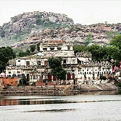
Charkhari is a city in Mahoba district in the state of Uttar Pradesh, India. This is the Kashmir of Bundelkhand. It was the capital of the Charkhari concession. There are lakes named Vijay Sagar, Malkhan Sagar, Vanshi Sagar, Jai Sagar, Ratan Sagar and Kothi Tal. There are 108 temples of Krishna giving the nature and beauty of Vraj to Charkhari city. In which Gopal Bihari temple of Sudamapuri, Guman Bihari of Ryanpur, temple of Mangalgarh, Bakht Bihari, temple of Banke Bihari and cave of Madavya Rishi are there. It is also the headquarters of Charkhari Tehsil and the name of Legislative Assembly seat is also Charkhari. Legislative Assembly constituency.

Contents

Geography

Charkhari is located at 25°24′N79°45′E / 25.4°N 79.75°E / 25.4; 79.75 . [1] It has an average elevation of 184 metres (603 feet). Charkhari is also known as the 'Kashmir of Bundelkhand'. The town is surrounded by many lakes. [2] There are lakes named Vijay Sagar, Malkhan Sagar, Vanshi Sagar, Jai Sagar, Ratan Sagar and Kothi Tal.[ citation needed ]

History

Charkhari State was one of the Princely states of India during the period of the British Raj. The state was founded in 1765 by Bijai Bahadur, a Rajput of Bundela clan. On India's independence, this Princely state was acceded to India. [3]

Demographics

As of 2011 India census, [4] Charkhari had a population of 27,760. Males constitute 53% of the population and females 47%. Charkhari has an average literacy rate of 58%, lower than the national average of 59.5%; with male literacy of 68% and female literacy of 47%. 16% of the population is under 6 years of age.

Related Research Articles

Ajaigarh or Ajaygarh is a town and a nagar panchayat in the Panna District of Madhya Pradesh state in central India.

<span class="mw-page-title-main">Banda, Uttar Pradesh</span> City in India

Banda is a city and a municipal board in Banda district in the state of Uttar Pradesh, India. Banda is divided between north, east, west and south Banda. Banda lies south of the Yamuna river in the Bundelkhand region. It is the administrative headquarters of Banda District. The town is well connected to major cities with railways and state highways. The town is near the right bank of the river Ken, 189 km south-west of Allahabad.

<span class="mw-page-title-main">Vindhya Pradesh</span> Former State of India

Vindhya Pradesh was a former state of India. It occupied an area of 61,131.5 km2. It was created in 1948 as Union of Baghelkhand and Bundelkhand States, shortly after Indian independence, from the territories of the princely states in the eastern portion of the former Central India Agency. It was named as Vindhya Pradesh on 25 January 1950 after the Vindhya Range, which runs through the centre of the province. The capital of the state was the former princely state of Rewa. It lays between Uttar Pradesh to the north and Madhya Pradesh to the south, and the enclave of Datia, which lay a short distance to the west, was surrounded by the state of Madhya Bharat.

<span class="mw-page-title-main">Chhatarpur</span> City in Madhya Pradesh, India

Chhatarpur is a city and a municipality in Chhatarpur district in the state of Madhya Pradesh, India. It is the administrative headquarters of Chhatarpur District. Chhatarpur is a city and a municipality in Chhatarpur district in the state of Madhya Pradesh, India. It is the administrative headquarters of Chhatarpur District.

<span class="mw-page-title-main">Sagar, Madhya Pradesh</span> City in Madhya Pradesh, India

Sagar is a city, municipal corporation and administrative headquarter in Sagar district of the state of Madhya Pradesh in central India. Situated on a spur of the Vindhya Range, 1,758 feet (536 m) above sea-level. The city is around 172 kilometres (107 mi) northeast of state capital, Bhopal.

<span class="mw-page-title-main">Mahoba</span> City in Uttar Pradesh, India

Mahoba is a city in Mahoba District of the Indian state of Uttar Pradesh in the Bundelkhand region, well known for the ninth century granite Sun temple built in Pratihara style. It is also well known for the 24 rock-cut Jain tirthankara image on Gokhar hill. Mahoba is known for its closeness to Khajuraho, Lavkushnagar and other historic places like Kulpahar, Charkhari, Kalinjar, Orchha, and Jhansi. The town is connected with railways and state highways.

Bundi is a city in the Hadoti region of Rajasthan state in northwest India and capital of the former princely state of Rajputana agency. District of Bundi is named after the former princely state.

<span class="mw-page-title-main">Tikamgarh</span> City in Madhya Pradesh, India

Tikamgarh is a town and a tehsil in Tikamgarh district in the Indian state of Madhya Pradesh. The city serves as a district headquarters. The earlier name of Tikamgarh was Tehri consisting of three hamlets, forming a rough triangle. In Tikamgarh town there is locality still known as 'Purani Tehri'. Until Indian independence in 1947, Tikamgarh, formerly called Tehri, was part of the kingdom of Orchha, which was founded in the 16th century by the Bundeli chief Rudra Pratap Singh, who became the first King of Orchha. In 1783 the capital of the state was moved to Tehri, about 40 miles (64 km) south of Orchha, which was home to the fort of Tikamgarh, and the town eventually took the name of the fort. The district is famous for the old fort of Kundar known as Garh Kundar, which was built by Khangars and remained the capital of Khangar rulers from 1180 to 1347.

Satna is a city in the Indian state of Madhya Pradesh. It serves as the headquarters of Satna district. It is 7th largest city and 8th most populous city of the state. The city is 500 km east of the state capital Bhopal. The city is distributed over a land area of 111.9 square kilometres.

<span class="mw-page-title-main">Sailana</span> City in Madhya Pradesh, India

Sailana is a town in the Malwa region of the Indian state of Madhya Pradesh. Sailana is 25 km (16 mi) from Ratlam city and 50 km (31 mi) away from Banswara district of the neighboring state of Rajasthan.

Sailana was once the capital of the Sailana State before it merged into India. A fort belonging to the former royal family still stands tall in Sailana. The Kedareshwar temple, situated 4 km (2.5 mi) from Sailana is a notable shrine.

<span class="mw-page-title-main">Lalitpur district, India</span> District in Uttar Pradesh, India

Lalitpur District is one of the districts of Uttar Pradesh state of India. Lalitpur district is a part of Jhansi Division. Lalitpur is the main town and administrative headquarters. The district occupies an area of 5,039 km².

Bijawar is a city the state of Madhya Pradesh, India. It is the administrative headquarters of Bijawar Taluk, and was formerly the capital of a princely state of British India of the same name. The people of Bijawar are demanding the district status from their state government. It is the 53rd proposed district of Madhya Pradesh

Mauranipur is a town and a municipal board in Jhansi district state of Uttar Pradesh, India. It is located in the Jhansi District. It is the largest tehsils in India by land area. This town was known for textile production, known in ancient times as Madhupuri. Because of its high density of temples, it is known by some locals as Mini-Ayoddhya. Jalvihar Mela and Viman Yatra are the most famous events in Mauranipur. The Kedareshwar temple and the Saprar Dam are located near Mauranipur.

<span class="mw-page-title-main">Kulpahar</span> City in Uttar Pradesh, India

Kulpahar is a city in Mahoba district in the Indian state of Uttar Pradesh. It is a historical town in the Bundelkhand region. Before 11 Feb 1995 Kulpahar was a Tehsil of Hamirpur District. On 11 Feb 1995 Mahoba District was carved out of Hamirpur, and Kulpahar is now a part of the Mahoba District. Kulpahar is the largest Subdivision of Uttar Pradesh. Kulpahar is known for its closeness to Khajuraho and other historic places like Mahoba, Charkhari, Kalinjar Rath, Orchha, and Jhansi. This town holds relics of temples and man-made water bodies of the Chandela Dynasty

Dehra Gopipur is a town, a Municipal Council, and a Tehsil in Kangra district in the state of Himachal Pradesh, India. The River Beas divides the town into Dera & Gopipur. The town of Dehra is as recent as mid-15th century when foreign invaders used this place as a dera (camp) for their expedition to hill states. British made the evolving town as the tehsil in year 1868. The official name of the town during British Raj was Dera.

Sarila is a town, a former princely state and a nagar panchayat in Hamirpur district in the northern Indian state of Uttar Pradesh.

Hatta is the biggest Tehsil in Damoh district in the state of Madhya Pradesh, India. It is also headquarters of Hatta Tehsil.

Manasa is a town with nagar palika in Neemuch district in the Indian state of Madhya Pradesh. It was under the princely state of Holker before Indian independence.

Deori, Sagar is a historical city situated on the banks of river " Aas " Sukhchain, on the Narsinghpur-Sagar city road. Deori kalan is a 150 year old municipality under Sagar district in the state of Madhya Pradesh, India.

<span class="mw-page-title-main">Charkhari State</span> Princely state of India

Charkhari State was one of the Princely states of India during the period of the British Raj. On India's independence, this Princely state acceded to India. Currently Charkhari town, the former state's capital, is a part of Uttar Pradesh state.

References

  1. Falling Rain Genomics, Inc - Charkhari
  2. "India heritage hub". Archived from the original on 4 March 2016. Retrieved 11 February 2013.
  3. "India heritage hub". Archived from the original on 4 March 2016. Retrieved 11 February 2013.
  4. "Census of India 2001: Data from the 2001 Census, including cities, villages and towns (Provisional)". Census Commission of India. Archived from the original on 16 June 2004. Retrieved 1 November 2008.