Jajpur

Last updated

Jajpur
Town
Biraja Temple, Jajpur, Odisha, India, 13th century.jpg
The Biraja Temple in Jajpur
India Odisha location map.svg
Red pog.svg
Jajpur
Location in Odisha, India
India location map.svg
Red pog.svg
Jajpur
Jajpur (India)
Coordinates: 20°51′N86°20′E / 20.85°N 86.33°E / 20.85; 86.33
Country India
State Odisha
district Jajpur
Founded byJajati Keshari
Government
  TypeMunicipality
  Collector and District Magistrate of JajpurSingh Rathore [1]
  Superintendent of PoliceShri Rahul P R [2]
Area
  Total2,887.69 km2 (1,114.94 sq mi)
Elevation
8 m (26 ft)
Population
 (2011) [3]
  Total37,458
  Density620/km2 (1,600/sq mi)
Languages
  Official Odia
Time zone UTC+5:30 (IST)
Vehicle registration OD-04 &OD-34
Websitewww.jajpur.nic.in

Jajpur [4] (also known as Jajapur) is a town and a municipality in Jajpur district in the Indian state of Odisha. It was the capital of the Kesari dynasty, later supplanted by Cuttack. [3] [5] Now, it is the headquarter of Jajpur district.

Contents

Etymology and names

Jajpur, [6] the place of the ancient Biraja Temple, was originally known as Biraja. Other names of the town in the ancient texts include Viranja, Varanja-nagara, Varaha-tirtha. [7] The Bhauma-Kara kings established their capital city of Guhadevapataka (or Guheshvarapataka), identified with modern Gohiratikar (or Gohiratikra) near Jajpur. [8] The later Somavanshi kings moved their capital from Yayatinagara (modern Binka) to Guheshvarapataka, and renamed the town Abhinava-Yayatinagara ("the new city of Yayati"). [7]

Later, the Jajpur [9] town came to be known as Yajanagara. According to one theory, this name is a corruption of "Yayatinagara". Another theory is that it derives from the Brahmanical sacrifices ( Yajna ) that became popular during the Ganga-Gajapati period (11th-16th century). [10] In the Muslim chronicles such as Tabaqat-i-Nasiri and Tarikh-i-Firuzshahi, the town's name was mentioned as "Jajnagar". Later, the suffix "-nagar" ("town") was replaced with the equivalent " -pur ", and the town's name became "Jajpur". [7]

History

Earliest account of Jajpur is part of the history of the Odisha. It was the capital of Keshari King Yayati Keshari in 473 CE. [11] Accounts by Chinese travelers mention Jajpur as capital in 7th century. It has been a center of Tantrism. The Buddhist kingdom of Bhauma Karas also kept Jajpur as their capital in 8th century CE. Many Buddhist structures have been unearthed in and around Jajpur i.e. in Ratnagiri,Udayagiri and Lalitagiri that point to the Buddhist past of the town. [5] [12]

Geography and climate

Jajpur [13]
Climate chart (explanation)
J
F
M
A
M
J
J
A
S
O
N
D
 
 
41
 
 
29
15
 
 
26
 
 
32
19
 
 
28
 
 
35
23
 
 
49
 
 
37
25
 
 
131
 
 
38
26
 
 
243
 
 
35
26
 
 
341
 
 
32
26
 
 
401
 
 
32
25
 
 
270
 
 
32
25
 
 
196
 
 
32
23
 
 
37
 
 
31
19
 
 
39
 
 
29
15
Average max. and min. temperatures in °C
Precipitation totals in mm
Imperial conversion
JFMAMJJASOND
 
 
1.6
 
 
85
59
 
 
1
 
 
90
66
 
 
1.1
 
 
96
73
 
 
1.9
 
 
99
77
 
 
5.1
 
 
100
79
 
 
9.6
 
 
94
79
 
 
13
 
 
90
78
 
 
16
 
 
89
78
 
 
11
 
 
90
77
 
 
7.7
 
 
90
74
 
 
1.5
 
 
87
66
 
 
1.5
 
 
84
59
Average max. and min. temperatures in °F
Precipitation totals in inches

Jajpur is located at 20°51′N86°20′E / 20.85°N 86.33°E / 20.85; 86.33 [14] and has an average elevation of 8 metres (26 ft). The climate of Jajpur District is normal as per Indian standards. All the seasons arrive in the District at their usual time. The District's average height from the sea level is 331 m and its average rain fall is 1014.5 mm. The average maximum and minimum temperatures are 40 degree C and 10 degree C respectively. Overall, the climate of the District is neither hotter nor cooler. The summer season is from March to June when the climate is hot and humid. Thunderstorms are common at the height of the summer. The monsoon months are from July to October when the town receives most of its rainfall from the South West Monsoon. The annual rainfall is around 1014.5 mm. The winter season from November to February is characterised by mild temperatures and occasional showers.

Climate data for Jajpur
MonthJanFebMarAprMayJunJulAugSepOctNovDecYear
Average high °C (°F)29.2
(84.6)
32.3
(90.1)
35.4
(95.7)
37.0
(98.6)
37.5
(99.5)
34.7
(94.5)
32.3
(90.1)
31.8
(89.2)
32.3
(90.1)
32.0
(89.6)
30.7
(87.3)
29.0
(84.2)
32.9
(91.1)
Average low °C (°F)15.2
(59.4)
18.7
(65.7)
22.6
(72.7)
25.0
(77.0)
26.2
(79.2)
26.1
(79.0)
25.5
(77.9)
25.3
(77.5)
25.0
(77.0)
23.3
(73.9)
19.1
(66.4)
15.0
(59.0)
22.3
(72.1)
Average precipitation mm (inches)41.3
(1.63)
26.0
(1.02)
27.8
(1.09)
48.5
(1.91)
130.6
(5.14)
243.4
(9.58)
340.6
(13.41)
401.1
(15.79)
269.5
(10.61)
195.8
(7.71)
37.2
(1.46)
38.5
(1.52)
1,800.3
(70.87)
Source: Jajpur Weather

Demographics

Jajpur
Jajpur
Jajpur

As of 2011 Indian Census, Jajpur municipality had a total population of 37,458, of which 19,216 were males and 18,242 were females. Population within the age group of 0 to 6 years was 3,823. The total number of literates in Jajpur was 29,975, which constituted 80.0% of the population with male literacy of 83.5% and female literacy of 76.4%. The effective literacy rate of 7+ population of Jajpur was 89.1%, of which male literacy rate was 92.9% and female literacy rate was 85.1%. The Scheduled Castes and Scheduled Tribes population was 6,363 and 565 respectively. Jajpur had 8198 households in 2011. [3]

Education

Colleges

Places of interest

See also

Related Research Articles

Kalinga is a historical region of India. It is generally defined as the eastern coastal region between the Mahanadi and the Godavari rivers, although its boundaries have fluctuated with the territory of its rulers. The core territory of Kalinga now encompasses central and southern Odisha and northern Andhra Pradesh. At its widest extent, the Kalinga region also included parts of present-day Chhattisgarh, extending up to Amarkantak in the west.

<span class="mw-page-title-main">Gajapati district</span> District of Odisha in India

Gajapati district is a district of Odisha State in India. It was created from Ganjam District on 2 October, 1992. Gajapati district was named after Krushna Chandra Gajapati Narayan Deb, the King of the Paralakhemundi estate and the first Prime Minister of Orissa, who is remembered for his contribution in the formation of a separate state, and inclusion of his estate in Odisha. The district headquarters at Paralakhemundi, formerly a Zamindari, has been clustered within a radius of approximately 5 kilometers around the geometric centre of Paralakhemundi. The District is a part of the Red Corridor. As of 2011 it is the third least populous district of Odisha, after Debagarh and Boudh.

<span class="mw-page-title-main">Baitarani River</span> River in India

The Baitarani is one of six major rivers of Odisha, India. Venerated in popular epics and legends, the Baitarani River is a source of water for agricultural irrigation. The coastal plain of Odisha has the name of "Hexadeltaic region" or the "Gift of Six Rivers". These deltas divide the coastal plain into three regions from north to south. The Baitarani, the Mahanadi and the Brahmani rivers form the Middle Coastal Plain, with evidence of past "back bays" and present lakes.

Kendrapara is a Town and a municipality in the Kendrapara district of the Indian state of Odisha. It is the headquarters of Kendrapara district.

<span class="mw-page-title-main">Boudh district</span> District of Odisha in India

Boudh District is an administrative and a municipal district, one of the thirty in the Odisha, India. The district headquarters of the Boudh District is the city of Boudh.

Byasanagar or Vyasanagar is a town and a municipality in Jajapur district in the state of Odisha, India. Colloquially it is also called Jajpur Road. It is home to an industrial belt and hosts several steel companies including Neelachal Ispat Nigam Limited, MESCO, Tata Steel, Jindal Steel etc. According to district officials there are around 14 major companies and several small companies in the vicinity. The city is also home to some eminent people in Odisha, including P. C. Ghadei, Late Ashok Das, Ram Chandra Khuntia (Congress) ,political leader Giridhari Barik (BJD),Priti Ranjan Ghadei (MLA), actor Akash Dasnayak, and his actress aunt the veteran Ms. Anita Dash, actress Naina Das with several other leaders and eminent personalities, its come under the Korei vidhan shabha

<span class="mw-page-title-main">History of Odisha</span> History of the Indian state of Odisha

The history of Odisha begins in the Lower Paleolithic era, as Acheulian tools dating to the period have been discovered in various places in the region. The early history of Odisha can be traced back to writings found in ancient texts like the Mahabharata, Maha Govinda Sutta and some Puranas. The region was also known to other kingdoms in region of East Indies due to maritime trade relations.

This article lists monuments and sites of historic importance in Odisha, India.

<span class="mw-page-title-main">Mukhalingam</span> Village in Andhra Pradesh, India

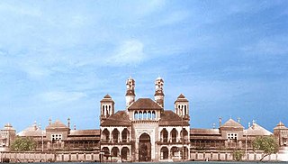
Mukhalingam, also known as Srimukhalingam or Mukhalinga, is a village panchayat in Jalumuru mandal of Srikakulam district in the Indian state of Andhra Pradesh. Historically known as Kalinganagari, Mukhalingam served as the capital of Eastern Ganga Dynasty from 6th century AD to 12th century AD. Emperor Sri Ananthavarma Chodaganga Devara conquered Utkala(Odisha) in 1122 AD and shifted the capital from Kalinganagari to Caudwara kataka

<span class="mw-page-title-main">Pushpagiri Vihara</span> Buddhist site in Odisha, India

Pushpagiri was an ancient Indian mahavihara or monastic complex located atop Langudi Hill in Jajpur district of Odisha, India. Pushpagiri was mentioned in the writings of the Chinese traveller Xuanzang and some other ancient sources. Until the 1990s, it was hypothesised to be one or all of the Lalitgiri-Ratnagiri-Udayagiri group of monastic sites, also located in Jajpur district. These sites contain ruins of many buildings, stupas of various sizes, sculptures, and other artifacts.

<span class="mw-page-title-main">Utkala Brahmin</span> Hindu Brahmin Community

Utkala Brahmins, also known as Odia Brahmins, are a Brahmin community who belong to the state of Odisha, India. Utkala Brahmins are the historical caretakers of the Jagannath Temple in Puri. The Utkala Brahmins are one of the five Pancha Gouda Brahmin communities that originally resided to the north of the Vindhyas. They constitute about 7% of Odisha's population.

Odia Muslims are a community of people hailing from the Indian state of Odisha who follow Islam and primarily speak Odia language. They mostly descend from indigenous converts to Islam along with a small proportion that migrated from northern India. They are marked by their distinctive religious practices, food habits and language.

<span class="mw-page-title-main">Lalitgiri</span>

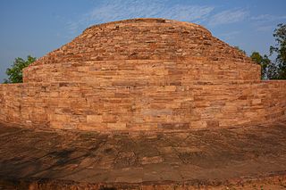
Lalitagiri is a major Buddhist complex in the Indian state of Odisha. The complex is home to stupas, 'esoteric' Buddha images, and monasteries (viharas), which is the oldest site in the region. Significant finds at this complex include Buddha's relics. Tantric Buddhism was practiced at this site.

<span class="mw-page-title-main">Varahanatha Temple</span> Hindu temple dedicated to the god Varaha in India

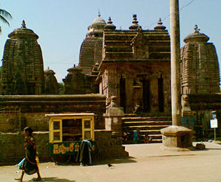
The Varahanatha Temple, also known as Yajna Varaha Temple, is a Hindu temple complex, located on the left bank of the Vaitarani River on an island formed by the river, in Jajpur, Odisha, India. The main shrine is dedicated to Varaha, the boar avatar of the god Vishnu. Built in 15-16th century, the temple is constructed in Kalinga architectural style. Besides the central Varaha shrine, there are numerous subordinate shrines to deities like Shiva, Vishnu, Vimala and others.

<span class="mw-page-title-main">Bhanja dynasty</span> Ancient dynasty originated in fhe Utkala Kingdom

The Bhanja dynasty is a dynasty that originated in the northern and central regions of modern Odisha before the Gupta Empire became an imperial power. The dynasty, of ancient local Kshatriya lineage as documented by Hermann Kulke, succeeded the Vindhyatabi branch of the Nagas of Padmavati, who ruled from the Keonjhar district of Odisha and included Satrubhanja of the Asanpat inscription. The Bhanj later became feudatories of the Bhauma-Kara dynasty.

Chhinnamasta Devi Temple is a Shakti Pitha of Goddess Kali located at Haladibasanta village, Tangi block of Cuttack District in Odisha, India.

The Bhauma dynasty, also known as Kara dynasty, ruled in eastern India between 8th and 10th centuries. Their kingdom, called Toshala, included parts of present-day Odisha.

The Somavamshi or Keshari dynasty ruled parts of present-day Odisha in eastern India between the 9th and the 12th centuries. Their capitals included Yayatinagara and Abhinava-Yayatinagara.

The Odia calendar is a solar calendar used by the Odia people from the Odisha region of the Indian subcontinent. The calendar follows the sidereal solar cycle while using the lunar Purnimanta phase for the religious dates. The New Year in the Odia calendar is known as Maha Bishuba Sankranti or Pana Sankranti. It occurs on the first day of the traditional solar month of Meṣa, hence equivalent lunar month Baisakha. The Odia calendar follows the Utkaliya era, which began on Bhādra śukla dvādaśī from 592 CE.

References

  1. "Collector & District Magistrate of Jajpur District". District Portal Jajpur. Retrieved 20 October 2016.
  2. "Who's Who | Jajpur District:Odisha | India" . Retrieved 6 May 2021.
  3. 1 2 3 "Census of India: Jajpur". www.censusindia.gov.in. Retrieved 7 January 2021.
  4. Das, Saudamini; Vincent, Jeffrey R.; Daily, Gretchen C. (2009). "Mangroves Protected Villages and Reduced Death Toll during Indian Super Cyclone". Proceedings of the National Academy of Sciences of the United States of America. 106 (18): 7357–7360. doi: 10.1073/pnas.0810440106 . ISSN   0027-8424. JSTOR   40483277. PMC   2678660 . PMID   19380735.
  5. 1 2 Rout, K.C. (1988). Local Self-government in British Orissa, 1869-1935. Daya Publishing House. p. 35. ISBN   978-81-7035-046-0 . Retrieved 21 June 2019.
  6. Nath, Suryakant (2013). "Gandhi's Harijan Padyatra in Orissa in 1934: Claims over a Contested Social Space". Proceedings of the Indian History Congress. 74: 564–570. ISSN   2249-1937. JSTOR   44158858.
  7. 1 2 3 Thomas E. Donaldson 2001, p. 51.
  8. Thomas E. Donaldson 2001, p. 6.
  9. Saran, Richard D.; Ziegler, Norman P. (2001), "THE TRANSLATIONS", The Mertiyo Rathors of Merto, Rajasthan, Select Translations Bearing on the History of a Rajput Family, 1462–1660, Volumes 1–2, University of Michigan Press, pp. 81–216, doi: 10.3998/mpub.19305 , ISBN   978-0-89148-085-3, JSTOR   10.3998/mpub.19305 , retrieved 6 May 2021
  10. Kailash Chandra Dash 2010, p. 169.
  11. Asiatic Society (Calcutta, India); Asiatic Society of Bengal (1871). Journal of the Asiatic Society of Bengal. Bishop's College Press. p. 151. Retrieved 21 June 2019.
  12. Deshpande, A. (2013). Buddhist India Rediscovered. Jaico Publishing House. p. 245. ISBN   978-81-8495-247-6 . Retrieved 21 June 2019.
  13. Chhotray, G. P.; Pal, B. B.; Khuntia, H. K.; Chowdhury, N. R.; Chakraborty, S.; Yamasaki, S.; Ramamurthy, T.; Takeda, Y.; Bhattacharya, S. K.; Nair, G. Balakrish (2002). "Incidence and Molecular Analysis of Vibrio cholerae Associated with Cholera Outbreak Subsequent to the Super Cyclone in Orissa, India". Epidemiology and Infection. 128 (2): 131–138. doi:10.1017/S0950268801006720. ISSN   0950-2688. JSTOR   3865257. PMC   2869804 . PMID   12002529.
  14. "Maps, Weather, Videos, and Airports for Jajpur, India".

Bibliography