Belpahar

Last updated

Belpahar
Town
India Odisha location map.svg
Red pog.svg
Belpahar
Location in Odisha, India
India location map.svg
Red pog.svg
Belpahar
Belpahar (India)
Coordinates: 21°49′18″N83°50′45″E / 21.8218°N 83.8458°E / 21.8218; 83.8458
CountryFlag of India.svg  India
State Odisha
District Jharsuguda
Population
 (2001)
  Total32,807
Languages
  Official Odia
Time zone UTC+5:30 (IST)
PIN
768218
Vehicle registration OR-23/OD-23
Sex ratio 1.166 /
Website odisha.gov.in

Belpahar is a town and a municipality in Jharsuguda district in the state of Odisha, India. Belpahar is famous for its geographical location, as it is the center for many coal mines areas nearby. Krosaki TRL Limited is located in Belpahar while there is Mahanadi Coalfields Limited and Ib Thermal Power station in the vicinity. It has a railway station which levels 55 metres high above the sea level. This area is among the fastest-growing industrial zones in Odisha.

Contents

Demographics

[ needs update ] As of the 2011 Census of India, [1] Belpahar had a population of 38,832. Males constitute 54% of the population and females 46%. Belpahar has an average literacy rate of 75%, higher than the national average of 59.5%; with 60% of the males and 40% of females literate. 11% of the population is under 6 years of age.

Villages near Belpahar

Belpahar has many villages and cities under its municipality. Some of the villages and localities include Muchbahal, Jurabaga, Jamkani, Mahulpada, Gumadera, Kuiltapada, Limtikra, Chingriguda, Jurabaga, Kadel Munda, Chhualiberna, Kadupada, Nayapada, Kisanpada, Khukhelmal, Gotiapada, Harijanpada, Jahajpadia, Malipada, Mirdhadera.Gandhinagar, Rehmatnagar Belpahar municipality is surrounded by localities like Jharsuguda, Brajrajnagar, Piplimal, Kudaloi, Kudopali, Kantapali, Kirmira, Khairkuni, Darlipali, Liakhai, and Junadihi.

Transport

Belpahar is well connected by road, rail air. Belpahar railway station is well connected with trains from Howrah, Mumbai, New Delhi, Bhubaneswar and Ahmedabad. Jharsuguda which is 22 km from Belpahar is connected from the rest of the country including Chennai and Bangalore.

Belpahar is connected through direct buses from Rourkela, Bhubaneswar, Sambalpur, Bhadrak and Raipur. National Highway 200 connects Belpahar directly to Raipur.

Economy

Belpahar is surrounded by many coal mines. The IB thermal power plant is located near Belpahar. The major industry is TRL Krosaki Ltd. (formerly Tata Refactories Limited). Other important industries surrounding Belpahar are IB Thermal Power Plant and Mahanadi Coal Field. Other Industries:- (i) New Simplex Industries (ii) Shyam Engineering Works (iii) ICI Chemicals (iv) Ib Valley Metal Forming (P) Ltd.

Education

Belpahar has six major schools. Girdhar Lal Tanna High School (GLHS), Aadarsh Balika Utchya Vidyalay (ABUV), Belpahar English Medium School (BEMS), Vivekananda International School (VIS), and the Belpahar Refractory High school (BRHS), which prepares students for higher secondary education. Beside this Saraswati sishu vidya mandir (SSVM) also groom students in there gurukul like green campus near Kadelpita of Belpahar. Of these, Girdhar Lal H.S. is the oldest. BEMS & VIS follow the curriculum of ICSE (Class 10) and ISC (Class 12). BRHS follow the curriculum of the Odisha State Board of secondary education and it is the leading Odia medium school in the district of Jharsuguda. For higher studies, Belpahar college offers graduate degrees in commerce and arts. Apart from these many government primary schools are present in different villages of Belpahar. Other than this nearby places like Bandhbahal and Brajrajnagar offer schools like D.A.V public school for students.

Famous People Of Belpahar

  1. Prasanna Kumar Panda: MLA (Brajrajnagar) Veteran Communist party leader of western Odisha
  2. Amresh Chandra Satapathy International Research Scientist (USA, Canada and UK), First IAS physics author of India

Sports

TRL Ground is one of the biggest ground in state. Surrounded by gallery of sitting capacity 10,000 people at once. It has witnessed many state level cricket tournament and national level ladies' football tournament. Moreover, various events like Balyashree Olympiad are organized here. Parades and various cultural programs from schools during Independence day and Republic day are held here. On the eve of Dussehra, a huge Ravan idol is burnt here with a great pomp and joy. Regular football and volleyball matches are held here.

Places of interest

Belpahar also has some nearby tourist attractions such as Koili Ghoghar (35 kilometres from Belpahar), Lal Pathar (8 km from Belpahar), Khadu (5 kilometres from Belpahar), Bikramkhol in Banjari village, Ullapgarh & Ujjalpur (7 kilometres from Belphar), Jagannath Temple, Nava Durga Temple (Gandhi Nagar, Belpahar) and IB river (8 kilometres from Belpahar). The Sani mandir at Sukha Bandh also attracts many devotees.

Belpahar has one beautiful park named Jubilee Park having a large variety of flowers and water fountain cover with light work. The name of this park has been changed to JRD TATA Park.

Apart from this, Belpahar also has a TRE club for the employees working in TRL Krosaki Ltd. The club has gym and a library, known by Gopabandhu Library. Another hall, called Jubilee Hall, holds many functions including marriages, pujas, and some magic.

Belpahar and surrounding areas are full of minerals. Makarchatta - (3 kilometres from Belpahar), Sitaram pahad (2.5 km from Belpahar). Bikram Khol(4 kilometres from Belpahar), Lal pathar(4.5 kilometres from Belpahar), Khadu(5 kilometres from Belpahar), Banjari (3 kilometres from Belpahar).

Bikram Khol

On NH-200 at about 5 km from Belpahar there is a village known as Banjari. In the vicinity of the village the ancient cave of Bikramkhol is located. In this inaccessible dense forest ancient people lived surviving on fruits, roots and animal meat. During 4000 BC there was evolution of human civilization in the region and a script was developed by them.

There are some ancient script engraved in the wall of Bikramkhol and also paintings of animals. Circular holes have been dug in the wall where weapons, dress and other articles of use were being kept suspended. Even on the floors circular holes have been dug to pound the grains. Bikramkhol has been declared a tourist spot by the Central Government and tourists, historians and researchers from all over the country and abroad.

Koili Ghoghar

View of Koili Ghoghar Koilighugar Waterfall, Jharsuguda.jpg
View of Koili Ghoghar

A scenic tourist spot about forty-five minutes away from Belpahar Railway Station on the way to Raigarh, Koili Ghoghar houses a beautiful river carving its way out of rock faces and cascading down in steps. It is a breathtaking sight during the rainy season. There are the resident ducks and monkeys that provide quite an entertainment for the tourists. It is a favoured picnic spot with people coming from far and near for a view of the lush greenery, surreal rock faces and the creamy waters cascading down the rocks. There is also a Shiva temple and a temple venerating a local deity for those with a religious vein. The town also has a Maa Tarini temple, near the NAC Checkpost (which is not closed), in the dense forest.

Ullapgarh

View of surrounding hillocks from Ullapgarh Ullapgarh.jpg
View of surrounding hillocks from Ullapgarh

This is a hillock about fifteen minutes away from Belpahar Railway Station. It is said that the revolutionaries fighting in the freedom struggle of India took refuge in this hillock. The spaces carved out from the rock face to hold torches can be seen to this day. The journey uphill entails one to be of a strong disposition as the sun and the dry heat can take their toll on one's bodily fluids. But once the summit is reached, it is a view to behold. Greenery combined with the piercing silence is a great restorative. It would be advised to remember one's way up lest one may find themselves going down by a completely different path and hence get lost. It is a picnic spot.

On the foot of Maheswar Pahad, there is a small village called "Ulap". About one kilometer from the village, the ruins of Ulapgarh are situated. At this place, the Maheswar pahad is about 1000 ft high and on the top there is a huge plain surface. On this rectangular plain stone surface the fort of Ulapgarh had been constructed. The plain stone fine surface is about 400 metre long and 250 metre wide. On the eastern side of the fort there are almost 7 km of densely forested Baramunda Hills and on the western side, the Belpahar Railway Station is located at a distance of 5 km. On the north there is a dense forest stretching up to Hemgir and in the south stretching up to Badjob village.

A 12 ft (3.66 m) wide and 500 ft (150 m) long moat had been constructed which stretches from east to west. There was a Sivalingam and a place of worship in the Fort. A well had been dug on the stone floor which provided drinking water to the inmates of the Fort throughout the year.

On the stone floor, there are many square holes and 70 round holes. The diameters of the hole vary from 1-3 inches. Wooden poles used to be put on these holes to support super structures for living room, store room, arsenals, kitchen, sleeping room, etc.

About 1000 people could take shelter at Ulapgarh at a time. On the western side of Ulapgarh and down hill there is Ushakothi cave. On the walls and floors of this cave also there are many circular and square holes. Probably the defence personnel of the fort used to suspend their clothes and other belonging from wooden poles fitted to these holes. The soldiers of the dense forest of Maheswar hill could easily over power and defeat the enemies before they could climb up the hill and attack the fort.

It is believed that Ulapgarh was being used as a residential fort by some kings of "Naja" Dynasty. This is being researched by both Indian and foreign researchers and historians.

Related Research Articles

<span class="mw-page-title-main">Baripada</span> City in Odisha, India

Baripada is a city and a municipality in Mayurbhanj district in the state of Odisha, India. Located along the east bank of the Budhabalanga river, Baripada is the cultural centre of north Odisha. In recent years, it has emerged as an educational hub with the opening of numerous professional colleges.

Bargarh is an emerging city and municipality in Bargarh district in the state of Odisha in India. It is the administrative headquarters of Bargarh District and is the 13th largest city of Odisha by population.

<span class="mw-page-title-main">Jharsuguda district</span> District in Odisha, India

Jharsuguda is a district in Odisha, India with Jharsuguda town as its headquarters. This region is rich in coal and other mineral reserves. Of late, many small and medium scale iron and steel units have been set up in the vicinity of Jharsuguda town, giving impetus to the industrial growth of the district.

<span class="mw-page-title-main">Jharsuguda</span> Town in Odisha, India

Jharsuguda is a city and district headquarters of Jharsuguda district of Odisha, India. It is an industrial hub, consisting mainly of metallurgical industries. It is well connected to major cities of India through the rail network, and a recently inaugurated Jharsuguda Airport, now renamed as Veer Surendra Sai Airport. It is popularly known as the "Powerhouse of Odisha" due to its Mega Steel, Aluminium & Power Projects. Its First Industrialist in SSI Steel Sector of the Region was Jayprakash Badhan. Jharsuguda has often been referred as "Little India" as well because of its diverse demography, language and culture. One of the oldest bar and hotel in region is Kalinga Bar.

<span class="mw-page-title-main">Nayagarh</span> Town in Odisha, India

Nayagarh is both a town and the municipality headquarters of the Nayagarh district in the Indian state of Odisha.

Rajgangpur is an industrial town situated in the Sundargarh District of Odisha. It is located 400 km to the north-west of the capital city, Bhubaneswar. It is located 30 km west of Rourkela. It is accessible by both road and rail. Rajgangpur Railway Station is on Mumbai-Rourkela line. Regular buses are available to Bhubaneswar, Cuttack, Rourkela and Angul. RGP Main Road is the main road of the town. The nearest functional airport is Veer Surendra Sai Airport, Jharsuguda which is approximately 95 km from Rajgangpur. Places of tourist interest in the vicinity of Rajgangpur include Mandira Dam, Chhatri Hill, Darjeeng, Vedvyas and Khandahar.

Brajrajnagar is a town and a municipality in Jharsuguda district in the state of Odisha, India. Popular legend says the town was named after Braj Mohan Birla after he set up Orient Paper Mills in 1936. It is a small sleepy town on rocky terrain, built on the banks of IB river, with temples mostly built by the Birlas. Later it became famous for MCL-owned coal mines after Orient Paper Mills of Birlas managed by dulichand Hanuman Prasad shah closed down in 1999.

<span class="mw-page-title-main">Parvathipuram, Andhra Pradesh</span> Place in Andhra Pradesh, India

Parvathipuram is a municipality located at Parvathipuram Manyam district of Indian state of Andhra Pradesh. It is the administrative headquarters of Parvathipuram Manyam district and headquarters of Parvathipuram revenue division and Parvathipuram mandal. This revenue division shares a border with various districts in Odisha.

<span class="mw-page-title-main">Junagarh, Kalahandi</span> Town/City in Odisha, India

Junagarh is a town and a notified area council in Kalahandi district in the Indian state of Odisha. MLA of Junagarh is Captain Divya Shankar Mishra. It was the capital of the former state of Kalahandi. Junagarh is 26 km from Bhawanipatna, connecting National Highway 201.This highway recently has been termed as National Highway 26.

Samasingha is a gram panchayat in the district of Jharsuguda in the state of Odisha in India. The block office and police station of Samasingha is Kolabira, site of the Kolabira fort. It is divided into fourteen wards. The MLA constituency is Jharsuguda and the MP constituency is Bargarh. The village is situated on the bank of the Bhede river, a tributary of the Mahanadi. Two small seasonal streams flow through the village, the larger is named Badbahal and the smaller Nalia. Bhugarapali, Junadihi, Belmunda, Jalapara/Jaladihi and Kumharmal are villages are in the neighbourhood of Samasingha. Other nearby places include Jharsuguda, Sambalpur, Kuchinda, Bamra and Bagdihi. The nearest place of tourist attraction is Gudguda. It is on the route between Sambalpur and Ranchi.

Lakhanpur is a tehsil in Jharsuguda district, Odisha, India. It is one among the largest block of Odisha and a village under Brajrajnagar assembly constituency and Bargarh parliamentary constituency.

<span class="mw-page-title-main">Koilighugar Waterfall</span> Waterfall in Odisha, India


Koilighugar Waterfall is in Jharsuguda district, Odisha, India.

<span class="mw-page-title-main">Veer Surendra Sai Airport</span> Airport in Odisha, India

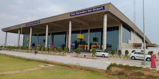
Veer Surendra Sai Airport, also known as Jharsuguda Airport, is a domestic airport serving Jharsuguda, Odisha, India. The airport is located 5 kilometres (3.1 mi) north-east from the city centre. The airport is located in Durlaga, approximately 8.5 km (5.3 mi) from Jharsuguda Junction Railway Station and around 63 kilometres from Sambalpur city. The airport is named after the revolutionary Veer Surendra Sai and it is the second commercial airport in the state of Odisha. The airport caters to areas like districts of Jharsuguda, Sambalpur, Sundergarh, Bargarh and Debagarh.

Bandhabahal is a small town in the Jharsuguda district in Odisha, India. It has a number of coal mines, which come under Mahanadi Coalfields Limited (M.C.L).

Ib Valley Coalfield is located in Jharsuguda district in the Indian state of Odisha, in the valley of the Ib River, a tributary of the Mahanadi. ′

Bhawanipatna is classified as one of the major tourist destinations by the tourism Department of Government of Odisha. All the tourist attraction in Kalahandi region comes under Bhawanipatna jurisdiction. Though tourist potential of Kalahandi has not been exploited optimally due to poor marketing, political negligence and infrastructure development, the land is very rich in terms of water fall, forest and wild life, natural and scenic beauty, tribal life, mountains, agriculture field, historical sites and handicrafts. The best time to visit Kalahandi region is from October to March. April–June is hard Summer and the mercury may rise to 45 degree C and June to August is the Monsoon Season. It occasionally rains in September, but do not miss the great festival like Nuakhai in September and Dassara in end of September or early October. Beginning of Dessara marks the pleasant weather condition till the celebration of Chaitra in February/March.

Jamkani is a village coming under Belpahar Municipality. The populants here generally speak Sambalpuri language. It is present at a distance of about 0.8 km from the TRL Stadium of Gumadera and nearly 1.4 km from Belpahar Railway Fatak. Nearly 10000 people reside in this place as of now, the correct population cannot be predicted because of village area. The total census is calculated for Belpahar.

Bhikampali is a medium-sized village in the Jharsuguda district of Odisha, India. It is situated on the banks of Badkelo River in the foothill of Chhelia Pahad. The village is located at a distance of 60 km from the district headquarter of Jharsuguda. It is within the Brajarajnagar assembly constituency, and the Bargarh Parliament constituency. As of 2011 census, its population is 920.

<span class="mw-page-title-main">JRD Tata Jubilee Park</span> Park in Odisha, India

JRD Tata Jubilee Park is located in the heart of the Gumadera area in the Belpahar city of Jharsuguda district of Odisha, India. The park contains a wide collection of aromatic and beautiful flowers which add a sense of calmness and peace to the environment.

Brajrajnagar railway station is a railway station on the South East Central Railway network in the state of Odisha, India. It serves Brajrajnagar town. Its code is BRJN. It has three platforms. Passenger, Express and Superfast trains halt at Brajrajnagar railway station.

References

  1. "Census of India 2001: Data from the 2001 Census, including cities, villages and towns (Provisional)". Census Commission of India. Archived from the original on 16 June 2004. Retrieved 1 November 2008.