Billings Township is a civil township of Gladwin County in the U.S. state of Michigan. As of the 2000 census, the township population was 2,715.

Hay Township is a civil township of Gladwin County in the U.S. state of Michigan. The population was 1,402 at the 2000 census.

Lafayette Township is a civil township of Gratiot County in the U.S. state of Michigan. The population was 656 at the 2000 census.

Nemuro is a subprefecture of Hokkaido Prefecture, Japan. Japan claims the southern parts of the disputed Kuril Islands as part of this subprefecture.

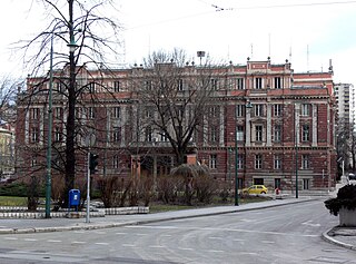
Centar is a municipality of the city of Sarajevo, Bosnia and Herzegovina. It is located between the older parts of the city under Stari Grad, and the newer more modern parts of the city under the municipalities Novi Grad and Novo Sarajevo.

The 1983 Monaco Grand Prix was a Formula One motor race held at Monaco on 15 May 1983. The race, contested over 76 laps, was the fifth race of the 1983 Formula One season and was won by Keke Rosberg, driving a Williams-Ford, with Nelson Piquet second in a Brabham-BMW and Alain Prost third in a Renault.

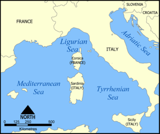
The Ligurian Sea is an arm of the Mediterranean Sea, between the Italian Riviera (Liguria) and the island of Corsica. The sea is theorized to be named after the ancient Ligures people.

Balangir is a city and municipality, the headquarters of Balangir district in the state of Odisha, India. Balangir has a rich cultural heritage. It is also known as the cultural hub of Western Odisha. Balangir municipality is divided into twenty one wards. It is spread over an area of 12,200 acres (4,900 ha).

The Algerian Air Force (AAF) is the aerial arm of the Algerian People's Military.

The 250 or so "Narrow Bantu languages" are conventionally divided up into geographic zones first proposed by Malcolm Guthrie (1967–1971). These were assigned letters A–S and divided into decades ; individual languages were assigned unit numbers, and dialects further subdivided. This coding system has become the standard for identifying Bantu languages; it was the only practical way to distinguish many ambiguously named languages before the introduction of ISO 639-3 coding, and it continues to be widely used. Only Guthrie's Zone S is (sometimes) considered to be a genealogical group. Since Guthrie's time a Zone J has been set up as another possible genealogical group bordering the Great Lakes.

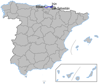
The Autopista AP-8 is a highway (autopista) in the north of Spain and crosses the Basque Country from east to west. It is known as the Autopista del Cantábrico and connects the French border with Bilbao. This toll road passes Donostia-San Sebastián, Zarautz, Eibar and Durango.

Isahakyan, known as Kharum until the 1820s, and later as Ghazarabad until 1945, is a village in the Shirak Province of Armenia. It was formerly named after Ghazar Agha who organized the defense of the town against the Persians in 1826-1828; later named after poet Avetik Isahakyan, who lived there.
Boulevard Heights is an urban neighborhood of Atlanta, Georgia located south of East Confederate Avenue, east of Boulevard, north of Entrenchment Creek and west of the State of Georgia complex. The area is currently undergoing redevelopment to add single family homes and light commercial premises.
Rourkela Railway Division refers to a campaign for a new railway division which would include Sundargarh, Jharsuguda and Kendujhargarh districts of Orissa, under EcoR. These stations are now under SER. Subrat Patnaik and the members of the Rourkela Development Forum have publicly demanded such a division.. Recently Shri Naveen Patnaik demanded Inclusion of Rourkela and Jajpur as Railway division under EcoR(currently These stations are under SER) following division of Waltair division from EcoR, which would lead to Unification of Railways in Odisha

Phulbani Airstrip is a private airstrip owned by Government of Odisha located at Phulbani in the Kandhamal district of Odisha. Nearest airport/airstrip to this airstrip is Nuagaon Airstrip in Balangir, Odisha.
Asian Workers Development Institute, Rourkela (AWDI) is a management institute located in sector 06 of city Rourkela. It was established in the year 1981 under Bastia Memorial Trust. The Instituteis affiliated to AICTE and Sambalpur University. In the year 2013 Business Today ranked AWDI at 183 as India's business school of east region of Odisha.

The canton of Montpellier-1 is an administrative division of the Hérault department, southern France. Its borders were modified at the French canton reorganisation which came into effect in March 2015. Its seat is in Montpellier.

Nuagaon railway station is a railway station on the South Eastern Railway network in the state of Odisha, India. It serves Nuagaon village. Its code is NXN. It has two platforms. Passenger, Express trains halt at Nuagaon railway station.


