Marripudi is a village in Prakasam district of the Indian state of Andhra Pradesh. It is the mandal headquarters of Marripudi mandal in Kandukur revenue division.

Chittoor district, is one of the eight districts in the Rayalaseema region of the Indian state of Andhra Pradesh. The district headquarters is located at Chittoor. It has a population of 4,170,468 according to 2011 census of India. It lies in the Poini river valley of southernmost Andhra Pradesh along the Chennai–Bangalore section of Chennai-Mumbai highway. Chittoor district is a major market centre for mangoes, grains, sugarcane, and peanuts.
Palamaner or Palamaneru is a town in Chittoor district of the Indian state of Andhra Pradesh. It is the mandal headquarters of Palamaner mandal and Palamaner Revenue Division
Pedda Raveedu is a village in Prakasam district of the Indian state of Andhra Pradesh. It is the mandal headquarters of Peda Araveedu mandal Markapur revenue division.
Bangarupalem mandal is one of the 66 mandals in the Chittoor district of the Indian state of Andhra Pradesh. Its headquarters are located at Bangarupalem. The mandal borders Tamil Nadu and is bounded by Palamaner, Gangavaram, Thavanampalle and Yadamari mandals of Chittoor district.
Buchinaidu Kandriga mandal or B. N. Kandriga mandal is one of the 34 mandals in Tirupati district of the Indian state of Andhra Pradesh. The mandal headquarters are located at Kanamanambedu. The mandal is bounded by Varadaiahpalem, K.V.B. Puram, Thottambedu mandals.

Puthalapattu is a Mandalam in Chittoor district of the Indian state of Andhra Pradesh. It is the mandal headquarters of Puthalapattu mandal. Puthalapattuis suburban of Chittoor city.
Santhipuram mandal is one of the 66 mandals in Chittoor district of the Indian state of Andhra Pradesh. The headquarters are located at Arimuthanapalle. The mandal is bounded by Ramakuppam, Kuppam and Gudupalle mandals..This mandal is under Kuppam Revenue Division.
Tirupati (urban) mandal is one of the 34 mandals in Tirupati district of the Indian state of Andhra Pradesh. It has its headquarters at Tirupati city&Tirupati district. The mandal is bounded by Chandragiri, Tirupati (rural) mandals. A part of it also borders Annamayya district.
Vijayapuram is a village in Chittoor district of the Indian state of Andhra Pradesh. It is located in Vijayapuram mandal of Nagari revenue division.
Kaliambakam is a village in Chittoor district of the Indian state of Andhra Pradesh. It is located in Vijayapuram mandal of Chittoor revenue division.
Jagannadhapuram is a village in Chittoor district of the Indian state of Andhra Pradesh. It is located in Vijayapuram mandal of Chittoor revenue division.
Pulicherla mandal is one of the 66 mandals in Chittoor district of the Indian state of Andhra Pradesh.
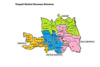
Tirupati revenue division is an administrative division in the Tirupati district of the Indian state of Andhra Pradesh. It is one of the 3 revenue divisions in the district with 9 mandals under its administration. Tirupati serves as the headquarters of the division. The division has 1 municipalities and 1 municipal corporation.
Chandragiri mandal is one of the 34 mandals in Tirupati district of the Indian state of Andhra Pradesh. It is under the administration of Tirupati revenue division and the headquarters are located at Chandragiri. The mandal is bounded by Chinnagottigallu, Pulicherla, Ramachandrapuram, Pakala, Penumuru, Vedurukuppam, Tirupati (urban) and Tirupati (rural) mandals.
Madanapalle mandal is one of the 66 mandals in Chittoor district of the Indian state of Andhra Pradesh. It is under the administration of Madanapalle revenue division and the headquarters are located at Madanapalle. The mandal is bounded by Kurabalakota, GurramKonda, Valmikipuram, Nimmanapalle, B. Kothakota, Punganur, Ramasamudram and the State of Karnataka.
Surutapalle is a village in Chittoor district of the Indian state of Andhra Pradesh. It is located in Nagalapuram mandal of Tirupati revenue division.
Tirupati district is one of the twenty-six districts in the Indian state of Andhra Pradesh and is one of the district in the Rayalaseema region of the Andhra Pradesh state. The district headquarters is located at Tirupati. Tirupati district is most famous for its numerous historic temples including the world-famous Hindu shrine of Tirumala Venkateswara Temple, Sri Kalahasteeswara temple and many others. The district is also home to Satish Dhawan Space Centre, a rocket launch centre located in Sriharikota and operated by Indian Space Research Organisation (ISRO). This district is surrounded by Nellore district to the North, Chittoor and Annamayya districts to the west and Tiruvallur district of Tamil Nadu to south and Bay of Bengal to the east. The river Swarnamukhi flows from Tirupati to Srikalahasti in this district. The major part of Pulicat Lake is present in this district.

Annamayya district one of the twenty-six districts in the Indian state of Andhra Pradesh and one of the eight districts in the Rayalaseema region. Rayachoti is the district administrative headquarters and Madanapalle is the largest city in the district. The district is named after the Annamacharya, a 15th-century Hindu saint hailing from Tallapaka, Rajampeta and the earliest known Indian musician to compose songs called sankirtanas in praise of the Lord Venkateswara. The district was formed from Madanapalle revenue division of Chittoor district and Rajampeta revenue division and a newly formed Rayachoti revenue division from Kadapa district. Madanapalle revenue division is the largest Revenue Division in the district. The newly formed district has 64.53% literacy rate, which is lower than state literacy which stands at 67.35%.

