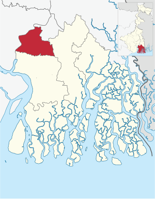
Howrah Sadar subdivision is a subdivision of the Howrah district in the state of West Bengal, India. It consists of Howrah municipal corporation and five community development blocs: Bally Jagacha, Domjur, Panchla, Sankrail and Jagatballavpur. The five blocks contain 67 gram panchayats and 44 census towns. The subdivision has its headquarters at Howrah.
Rural area under Bally Jagachha block consists of eight gram panchayats, viz. Bally, Durgapur Abhaynagar–I, Jagadishpur, Chakpara, Anandanagar, Nischinda, Durgapur Abhaynagar–II, Sanpuipara Basukati and Chamrail.[1] Urban area under this block consists of six census towns: Bally (Jagachha),[3]Chakapara, Chamrail, Eksara, Khalia and Jagadishpur.[2]Bally & Liluah police stations serve this block.[4] Headquarters of this block is in Kona.[5]
Rural area under Panchla block consists of 11gram panchayats, viz. Banharishpur, Chara–Panchla, Jalabiswanathpur, Sahapur, Beldubi, Deulpur, Jujarsaha, Suvarara, Bikihakola, Gangadharpur and Panchla.[1] Urban area under this block consists of seven census towns: Bikihakola, Beldubi, Jala Kendua, Gabberia, Paniara, Panchla and Sahapur.[2] Panchla police station serves this block.[4] Headquarters of this block is in Bikihakola.[5]
Rural area under Jagatballavpur block consists of 14gram panchayats, viz. Baragachhia–I, Islampur, Maju, Shankarhati–II, Baragachhia–II, Jagatballavpur–maju changghurali north, Pantihal, Shialdanga, Gobindapur, Jagatballavpur–II, Polegustia, Hantal Anantabati, Laskarpur and Shankarhati–I.[1] Urban area under this block consists of one census town: Mansinhapur.[2] Jagatballavpur policem station serves this block.[4] Headquarters of this block is in Munsirhat.[5]
Wards numbered 51-66 of the Howrah Municipal Corporation will form the Bally assembly constituency of West Bengal.
Wards numbered 1–7 and 10–16 of the Howrah municipal corporation will form the Howrah Uttar assembly constituency.
Wards numbered 17–20, 24–34, 36, 37 and 42 of the Howrah municipal corporation will form the Howrah Madhya assembly constituency.
Wards numbered 8, 9, 21–23, 43, 47–50 of the Howrah municipal corporation will form the Shibpur assembly constituency.
Wards 35, 38–41, 44–46 of the Howrah municipal corporation and the gram panchayats of Dulia, Jorhat, Panchpara and Thanamakua of the Sankrail block will form the Howrah Dakshin assembly constituency.
The other thirteen gram panchayats under the Sankrail block and the gram panchayats of Kolara–I, Kolara–II, Mahiyari–I and Mahiyari–II of the Domjur block will form the Sankrail assembly constituency.
The Panchla block and the gram panchayats of Gobindapur, Islampur, Laskarpur and Polegustia of the Jagatballavpur block will together form the Panchla assembly constituency.
The Jagatballavpur assembly constituency will cover the area under the other ten gram panchayats of the Jagatballavpur, and the gram panchayats of Begari, Domjur, Dakshin Jhapardaha, Parbatipur, Rudrapur, Uttar Jhapardaha and Makardah–I under the Domjur block.
The Bally Jagachha block and the gram panchayats of Bankra–I, Bankra–II, Bankra–III, Makardah–II, Narna, Shalap–I and Shalap–II under the Domjur block will together form the Domjur assembly constituency.
The assembly constituencies of Bally, Howrah Uttar, Howrah Madhya, Shibpur, Howrah Dakshin, Panchla and Sankrail will together form the Howrah (Lok Sabha constituency).
Howrah district is a district of the West Bengal state in eastern India. Howrah district is one of the highly urbanized area of West Bengal. It has thousands of years of rich heritage in the form of the great Bengali kingdom of Bhurshut. The district is named after its headquarters, the city of Howrah.
South 24 Parganas (Pron: pɔrɡɔnɔs; abbr. 24 PGS (S)), or sometimes South Twenty Four Parganas and Dakshin 24 Parganas, is a district in the Indian state of West Bengal, headquartered in Alipore. It is the largest district of West Bengal by area and second largest by population. It is the sixth most populous district in India (out of 640). On one side of the district there is the urban fringe of Kolkata, and on the other the remote riverine villages in the Sundarbans.
Chamrail is a census town in Bally Jagachha CD Block of Howrah Sadar subdivision in Howrah district in the Indian state of West Bengal. It is a part of Kolkata Urban Agglomeration.
Dakshin Jhapardaha is a census town in Domjur CD Block of Howrah Sadar subdivision in Howrah district in the state of West Bengal, India. It is close to Domjur and also a part of Kolkata Urban Agglomeration.
Islampur subdivision is an administrative subdivision of the Uttar Dinajpur district in the Indian state of West Bengal. This subdivision was earlier a part of Bihar and was transferred to West Bengal with the passing of the States Reorganisation Act in 1956.
Uluberia subdivision is a subdivision of the Howrah district in the state of West Bengal, India. It consists of Uluberia municipality and nine community development (CD) blocks, including 90 gram panchayats and six census towns. The six census towns are: Khalor, Bagnan, Naupala, Santoshpur, Balaram Pota and Uttar Pirpur. The subdivision has its headquarters at Uluberia. The whole division forms the Lok Sabha constituency of Uluberia.
Bally, sometimes spelled Bāli, is a census town in Bally Jagachha CD Block of Howrah Sadar subdivision in Howrah district in the Indian state of West Bengal. It is a part of Kolkata Urban Agglomeration.
Alipore Sadar subdivision is an administrative subdivision of the South 24 Parganas district in the Indian state of West Bengal.
Diamond Harbour subdivision is an administrative subdivision of the South 24 Parganas district in the Indian state of West Bengal.
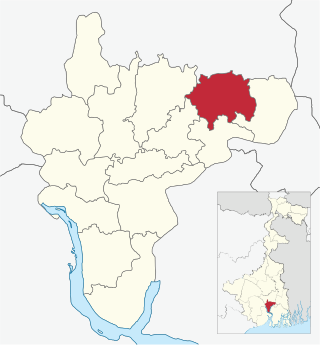
Jagatballavpur is a community development block that forms an administrative division in Howrah Sadar subdivision of Howrah district in the Indian state of West Bengal.
Howrah Dakshin Assembly constituency is an assembly constituency in Howrah district in the Indian state of West Bengal.
Sankrail is an assembly constituency in Howrah district in the Indian state of West Bengal. It is reserved for scheduled castes.
Jagatballavpur Assembly constituency is an assembly constituency in Howrah district in the Indian state of West Bengal.
Domjoor Assembly constituency is a legislative assembly constituency in Howrah district in the Indian state of West Bengal.
Bally Jagachha is a community development block that forms an administrative division in Howrah Sadar subdivision of Howrah district in the Indian state of West Bengal.
Domjur is a community development block that forms an administrative division in Howrah Sadar subdivision of Howrah district in the Indian state of West Bengal.
Panchla is a community development block that forms an administrative division in Howrah Sadar subdivision of Howrah district in the Indian state of West Bengal.
Sankrail is a community development block that forms an administrative division in Howrah Sadar subdivision of Howrah district in the Indian state of West Bengal.
Uluberia II is a community development block that forms an administrative division in Uluberia subdivision of Howrah district in the Indian state of West Bengal.
This page is based on this Wikipedia article Text is available under the CC BY-SA 4.0 license; additional terms may apply. Images, videos and audio are available under their respective licenses.