Tentulkuli | |
|---|---|
Census Town | |
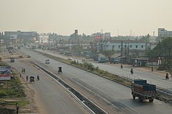 National Highway 16/ Asian Highway 45, Tentulkuli | |
 Tentulkuli Location in West Bengal, India  Tentulkuli Tentulkuli (West Bengal)  Tentulkuli Tentulkuli (India) | |
| Coordinates: 22°37′N88°16′E / 22.62°N 88.27°E | |
| Country | |
| State | West Bengal |
| District | Howrah |
| Population (2011) | |
• Total | 7,203 |
| Languages | |
| • Official | Bengali, English |
| Time zone | UTC+5:30 (IST) |
| Vehicle registration | WB |
| Lok Sabha constituency | Sreerampur |
| Vidhan Sabha constituency | Domjur |
| Website | howrah |
Tentulkuli is a census town in Domjur CD Block of Howrah Sadar subdivision in Howrah district in the Indian state of West Bengal. [1]