Howrah is a city in the Indian state of West Bengal. Howrah is located on the western bank of the Hooghly River, opposite its twin city of Kolkata. Administratively Howrah lies within Howrah district and is the headquarters of the Howrah Sadar subdivision; it is also part of the area covered by Kolkata Metropolitan Development Authority (KMDA). Howrah is an important industrial and transportation hub, and is also a gateway to Kolkata via Howrah railway station and Howrah Bridge.

The Hooghly River or popularly called Ganga or Kati-Ganga in the Puranas, is a river that rises close to Giria, which lies north of Baharampur and Palashi in Murshidabad. It is the western distributary of the Ganges. The main course of the Ganges then flows into Bangladesh as the Padma. A man-made canal, built in the 1960s and early-1970s at Farakka, connects the Ganges, flowing through Malda, to the Hooghly to bring the abundant waters of the Himalayan river to the comparatively narrow river that rises in eastern West Bengal.

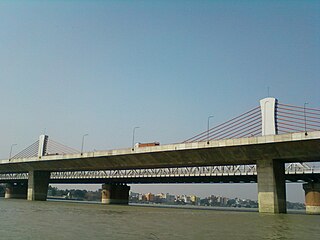
Vivekananda Setu is a bridge over the Hooghly River in West Bengal, India. It links the city of Howrah, at Bally, to Kolkata, at Dakshineswar. Completed in 1931, it is a multispan truss bridge that was built to primarily to provide direct road and rail connectivity between the Calcutta Port and the major railhead at Howrah railway station on the West bank of the Hooghly River. It is 880 metres (2,887 ft) long having 9 spans in total. The famous Dakshineswar Kali Temple is situated on the banks of the Hooghly River near the bridge. The bridge is one of the four bridges linking Howrah and Kolkata. A new road bridge, the Nivedita Setu, was constructed 50 m (160 ft) downstream in 2007 due to weakening of the Vivekanada Setu caused by its ageing.

Belur is a neighbourhood in Howrah of Howrah district in the Indian state of West Bengal. It is a part of the area covered by Kolkata Metropolitan Development Authority (KMDA). Belur is under the jurisdiction of Belur Police Station and Bally Police Station of Howrah City Police. The area is best known for Belur Math, a religious monastery containing a complex of temples. Belur Math is famous for being the headquarters of the Ramakrishna Math, a monastic order, as well as that of the related Ramakrishna Mission, both founded by Swami Vivekananda. On the opposite side of the Hooghly River, opposite to Belur Math is the Dakshineswar Kali Temple.

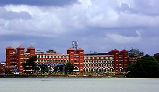
Uttarpara or Uttarpara Kotrung is a city and a municipality of Hooghly district in the Indian state of West Bengal. It is a part of the area covered by Kolkata Metropolitan Development Authority (KMDA). Uttarpara is located at 22.67°N 88.35°E, within 10 km from Kolkata, the capital of the state of West Bengal. It is located along the Hooghly river, across from the Dakshineswar Kali Temple. Uttarpara is home to the Uttarpara Jayakrishna Public Library, Asia's oldest free public library.
Kolkata the Capital of the Indian state of West Bengal has a good transportation system. Kolkata's transport system is diverse, with a mix of modern and traditional modes of transport catering to the city's large population.
Baidyabati is a city and a municipality of Hooghly district in the State of West Bengal in India. It is under Serampore police station of Srirampore subdivision. It is a part of the area covered by Kolkata Metropolitan Development Authority (KMDA).

Dankuni is a city and a municipality of Hooghly district in the Indian state of West Bengal. It is a part of the area covered by Kolkata Metropolitan Development Authority (KMDA). Positioned strategically near Kolkata, it has emerged as an important industrial and commercial center in the region. The city's landscape is characterized by a mix of residential areas and industrial zones, reflecting its dual identity as a place of habitation and economic activity.
Hindmotor is a neighbourhood in Uttarpara of Hooghly district in the Indian state of West Bengal. It is a part of the area covered by Kolkata Metropolitan Development Authority (KMDA).
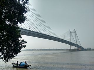
Nivedita Setu is a multi-span extradosed bridge spanning the Hooghly River, connecting Bally, Howrah with Dakshineswar, Kolkata. It runs parallel to and about 50m downstream of the old Vivekananda Setu, opened in 1932. The bridge is named after Sister Nivedita, the social worker-disciple of Swami Vivekananda. The bridge is one of only five roadway bridges crossing the Hooghly River within the Kolkata metropolitan region. Belghoria Expressway which connects the meeting point of NH-16 with NH-19 at Dankuni to NH 12, Kalyani Expressway, Kolkata Airport and northern parts of Kolkata passes over the bridge. The bridge is designed to carry 48,000 vehicles per day.
Mankundu is a neighbourhood in Bhadreswar of Hooghly district in the Indian state of West Bengal. It is a part of the area covered by Kolkata Metropolitan Development Authority (KMDA).
Bally is a census town in Bally Jagachha CD Block of Howrah Sadar subdivision in Howrah district in the Indian state of West Bengal. Bally is under the jurisdiction of Nischinda Police Station of Howrah City Police.
Salkia is a neighbourhood in Howrah of Howrah district in the Indian state of West Bengal. Salkia is under the jurisdiction of Golabari Police Station and Malipanchghara Police Station of Howrah City Police. It is a part of the area covered by Kolkata Metropolitan Development Authority (KMDA).
The Howrah–Barddhaman chord line is a broad-gauge rail line connecting Howrah and Bardhaman. The 95-kilometre-long (59 mi) railway line operates in Howrah, Hooghly and Purba Bardhaman districts in the state of West Bengal. It is part of the Howrah–Gaya–Delhi line, Howrah–Delhi main line, Howrah–Prayagraj–Mumbai line and the Kolkata Suburban Railway system.

The Calcutta Chord linkline, also known as the C.C. link line, is a 22 km (14 mi) long branch line of the Kolkata Suburban Railway which comes under the jurisdiction of Eastern Railway's Sealdah Division & Howrah Division.
Boinchi is a Census town located in Hooghly District in the Indian state of West Bengal. It is under Pandua Police Station in Chinsurah subdivision. The town is located approximately 71 kilometers from Kolkata via Howrah-Bardhaman Main Line. The nearest Railway Station is Bainchi railway station, which is under the Eastern Railway and a part of Kolkata Suburban Railway System.
Ghusuri is a neighbourhood in Howrah of Howrah district in the Indian state of West Bengal. It is a part of the area covered by Kolkata Metropolitan Development Authority (KMDA). Bhot Bagan Moth, Indian oldest Tibetan Buddhist monastery outside the Himalayas situated at Ghusuri. Ghusuri is under the jurisdiction of Malipanchghara Police Station of Howrah City Police.

Belanagar railway station is a Kolkata Suburban Railway station on the Howrah–Bardhaman chord line operated by Eastern Railway zone of Indian Railways. It is situated at Bally Jagachha Block, Belanagar in Howrah district in the Indian state of West Bengal. Number of EMU trains stop at Belanagar railway station. This railway station is named after Bela Mitra, a freedom fighter and social activist. This was the first Railway station in India named after any Indian woman.
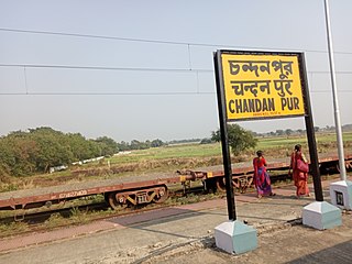
Chandanpur railway station is a Kolkata Suburban Railway station on the Howrah–Bardhaman chord line operated by Eastern Railway zone of Indian Railways. It is situated beside State Highway 2, Chandanpur in Hooghly district in the Indian state of West Bengal. A number of EMU trains stop at this station.
Madhusudanpur railway station is a Kolkata Suburban Railway station on the Howrah–Bardhaman chord line operated by Eastern Railway zone of Indian Railways. It is situated beside State Highway 2, Madhusudanpur in Hooghly district in the Indian state of West Bengal. Number of EMU trains stop at this station.


