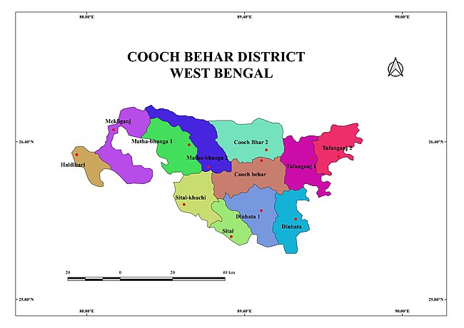
Tufanganj I

Last updated
Tufanganj I
Community development block
Tufanganj-I in Cooch Behar (West Bengal).svg
Coordinates: 26°24′57″N89°35′45″E / 26.415833°N 89.595833°E / 26.415833; 89.595833
CountryFlag of India.svg  India
State West Bengal
District Cooch Behar
Government
  Type Representative democracy
Area
  Total317.00 km2 (122.39 sq mi)
Population
 (2011)
  Total248,595
  Density780/km2 (2,000/sq mi)
Languages
  Official Bengali, English
Time zone UTC+5:30 (IST)
Lok Sabha constituency Alipurduars, Cooch behar
Vidhan Sabha constituency Tufanganj, Natabari
Website coochbehar.gov.in

Tufanganj I is a community development block (CD block) that forms an administrative division in the Tufanganj subdivision of the Cooch Behar district in the Indian state of West Bengal.

Contents

Geography

Natabari, a constituent panchayat of the block, is located at 26°24′57″N89°35′45″E / 26.415833°N 89.595833°E / 26.415833; 89.595833 .

Topographically Cooch Behar district is generally plain land which is low and marshy at some places. “Considering the nature of general surface configuration, relief and drainage pattern, distribution of different types of soil, climatic condition, the formation of geology and forest tracts, the district Koch Bihar falls under Barind Tract. The physiology of this area consists of alluvial soil, generally blackish brown in colour and composed of sand, clay and silt. The soils are loose and sandy throughout the district.” The Himalayan formations in the north end beyond the boundaries of this district. There are no hills/ mountains here. It has a large network of rivers flowing from north-west to south and south-east. The Teesta flows through Mekhliganj CD block before entering Bangladesh. The Jaldhaka and its connected river-streams form a large catchment area in the district. It virtually divides the district into two unequal parts and meets the Brahmaputra in Bangladesh. The Himalayan rivers flowing through Cooch Behar district change courses from time to time. In 1876, W.W. Hunter mentioned the Dharla and the Torsha as the same stream with two names. However, since the advent of the 20th century, these are two different streams meeting the Brahmaputra in Bangladesh. [1] [2]

The hill-streams of Cooch Behar carry debris and silt from the Himalayas and are shallow. During the monsoons the speed of flow of the rivers almost doubles and the rivers overflow the banks causing floods and devastation. The Raidak I and II, and Sankosh are the major rivers causing floods in the Tufanganj I and II CD blocks. [3]

The Tufanganj I CD block is bounded by the Alipurduar II CD block in Alipurduar district on the north, the Tufanganj II CD block and Agamoni revenue circle/tehsil in Dhubri district of Assam on the east, the Dinhata II CD block and Bhurungamari Upazila in Kurigram District of Bangladesh on the south, the Cooch Behar I and Cooch Behar II CD blocks on the west. [2] [4] [5]

The Tufanganj I CD block has an area of 317.00 km2. It has 1 panchayat samity, 14 gram panchayats, 192 gram sansads (village councils), 73 mouzas, 72 inhabited villages and 1 census towns. Tufangnj police station serves this block. [6] Headquarters of this CD block is at Tufanganj. [2]

Gram panchayats of Tufanganj I block/ panchayat samiti are: Andaran Fulbari I, Andaran Fulbari II, Balabhut, Balarampur I, Balarampur II, Chilakhana I, Chilakhana II, Deocharai, Dhalpal I, Dhalpal II, Maruganj, Nakkatigachh, Natabari I and Natabari II. [7]

Community development blocks in Cooch Behar district ADMINISTRATIVE MAP.jpg
Community development blocks in Cooch Behar district

Demographics

Population

According to the 2011 Census of India, the Tufanganj I CD block had a total population of 248,595, of which 243,256 were rural and 5,339 were urban. There were 128,415 (52%) males and 120,180 (48%) females. There were 29,090 persons in the age range of 0 to 6 years. The Scheduled Castes numbered 115,000 (46.26%) and the Scheduled Tribes numbered 378 (0.15%). [8]

According to the 2001 census, Tufanganj I block had a total population of 222,993, out of which 113,825 were males and 109,164 were females. Tufanganj I block registered a population growth of 16.47 per cent during the 1991-2001 decade. [9]

Census towns in the Tufanganj I CD block are (2011 census figures in brackets): Kamat Phulbari (P) (5,339). [8]

Large villages (with 4,000+ population) in the Tufanganj I CD block are (2011 census figures in brackets): Natabari (6,113), Chhat Rampur Dwitiya Khanda (5,773), Dhalpal (7,319), Charaljani (6,534), Airani Chitalia (5,036), Jaigir Chilakhaa (8,712), Andaran Phulbari (P), Ghogarkuthi Pratham Khanda (10,826), Chilakhana (9,263), Maradanga (8,775), Balarampur (34,113), Deocharai (7,849), Chamta (8,190), Dwiparpar (5,256), Nakkatigachhi (4,243), Jhaljhali (4,072), Krishnapur (5,740), Balabhut (10,008) and Jhaukuthi (4,273). [8]

Other villages in the Tufanganj I CD block include (2011 census figures in brackets): Dhadial (3,870) and Bhuchungmari (1,541). [8]

Literacy

According to the 2011 census, the number of literate persons in the Tufanganj I CD block was 161,744 (73.69% of the population over 6 years) out of which males numbered 90,476 (79.78% of the male population over 6 years) and females numbered 71,268 (67.17% of the female population over 6 years). The gender disparity (the difference between female and male literacy rates) was 12.61%. [8]

See also – List of West Bengal districts ranked by literacy rate

Literacy in CD Blocks of
Cooch Behar district
Cooch Behar Sadar subdivision
Cooch Behar I – 76.56%
Cooch Behar II – 81.39%
Dinhata subdivision
Dinhata I – 73.23%
Dinhata II – 72.33%
Sitai – 62.79%
Mathabhanga subdivision
Sitalkuchi – 70.34%
Mathabhanga I – 71.51%
Mathabhanga II – 72.68%
Tufanganj subdivision
Tufanganj I – 73.69%
Tufanganj II – 75.75%
Mekhliganj subdivision
Mekhliganj – 69.34%
Haldibari – 69.22%
Source:
2011 Census: CD Block Wise

Primary Census Abstract Data

Language and religion

Religion in Tufanganj I CD block (2011) [10]
Hinduism
69.85%
Islam
29.79%
Other or not stated
0.36%

In the 2011 Census of India, Hindus numbered 173,652 and formed 69.85% of the population of Tufanganj I CD block. Muslims numbered 74,065 and formed 29.79% of the population. Christians numbered 577 and formed 0.23% of the population. Others numbered 301 and formed 0.12% of the population. [10]

Languages of Tufanganj I CD block (2011) [11]

   Bengali (95.48%)
  'Other' Bengali (2.39%)
   Rajbongshi (1.73%)
  Others (0.40%)

At the time of the 2011 census, 95.48% of the population spoke Bengali and 1.73% Rajbongshi as their first language. 2.39% were recorded as speaking 'Other' under Bengali. [11]

Rural poverty

Based on a study of the per capita consumption in rural and urban areas, using central sample data of NSS 55th Round 1999-2000, Cooch Behar district had a rural poverty ratio of 25.62%. [12]

According to a World Bank report, as of 2012, 20-26% of the population of Cooch Behar, Birbhum, Nadia and Hooghly districts were below poverty line, marginally higher than the level of poverty in West Bengal, which had an average 20% of the population below poverty line. [13]

Economy

Livelihood

Livelihood
in Tufanganj I CD block

  Cultivators (24.69%)
  Agricultural labourers (34.95%)
  Household industries (9.94%)
  Other Workers (30.42%)

In the Tufanganj I CD block in 2011, among the class of total workers, cultivators numbered 24,856 and formed 24.69%, agricultural labourers numbered 35,176 and formed 34.95%, household industry workers numbered 10,007 and formed 9.94% and other workers numbered 30,618 and formed 30.42%. [14] Total workers numbered 100,657 and formed 40.49% of the total population, and non-workers numbered 147,938 and formed 59.51% of the population. [15]

Note: In the census records a person is considered a cultivator, if the person is engaged in cultivation/ supervision of land owned by self/government/institution. When a person who works on another person's land for wages in cash or kind or share, is regarded as an agricultural labourer. Household industry is defined as an industry conducted by one or more members of the family within the household or village, and one that does not qualify for registration as a factory under the Factories Act. Other workers are persons engaged in some economic activity other than cultivators, agricultural labourers and household workers. It includes factory, mining, plantation, transport and office workers, those engaged in business and commerce, teachers, entertainment artistes and so on. [16]

Infrastructure

There are 72 inhabited villages in the Tufanganj I CD block, as per the District Census Handbook, Cooch Behar, 2011. All of the villages have power supply and drinking water supply. 31 villages (43.06%) have post offices. 48 villages (66.67%) have telephones (including landlines, public call offices and mobile phones). 33 villages (45.83%) have pucca (paved) approach roads and 24 villages (33.33%) have transport communication (includes bus service, rail facility and navigable waterways). 9 villages (12.50%) have agricultural credit societies and 7 villages (9.72%) have banks. [17]

Agriculture

Agriculture is the primary mode of living in the district. The entire Cooch Behar district has fertile soil and around half of the cultivated land in the district is cropped twice or more. Paddy (rice) and jute are the largest producing crops, followed by potatoes, vegetables and pulses. There are 23 tea gardens on glided slopes. There are some coconut, areca nut and betel leaf plantations. 77.6% of the land holdings are marginal. [18]

In 2012-13, there were 89 fertiliser depots, 1 seed store and 49 fair price shops in the Tufanganj I CD block. [19]

In 2012–13, the Tufanganj I CD block produced 41,806 tonnes of Aman paddy, the main winter crop, from 18,986 hectares, 15,895 tonnes of Boro paddy (spring crop) from 5,412 hectares, 1,880 tonnes of Aus paddy (summer crop) from 1,122 hectares, 7,344 tonnes of wheat from 2,876 hectares, 1,617 tonnes of maize from 664 hectares, 83,866 tonnes of jute from 7,787 hectares, 68,042 tonnes of potatoes from 1,799 hectares and 77,903 tonnes of sugar cane from 745 hectares. It also produced pulses and oilseeds. [19]

In 2012-13, the total area irrigated in the Tufanganj I CD block was 5,545 hectares, out of which 90 hectares were irrigated by private canal water, 1,565 hectares by tank water, 689 hectares by river lift irrigation, 200 hectares by deep tube wells, 2,160 hectares by shallow tube wells, 91 hectares by open dug wells, 750 hectares by other means. [19]

Pisciculture

Being a river-bound district, pisciculture is an important economic activity in the Cooch Behar district. Almost all the rivers originating in the Himalayas have a lot of fish. The net area under effective pisciculture in 2010-11 in the Tufanganj I CD block was 297.06 hectares. 12,250 persons were engaged in the profession and approximate annual production was 19,904 quintals. [20]

Banking

In 2012-13, Tufanganj I CD block had offices of 7 commercial banks and 6 gramin banks. [19]

Transport

Tufanganj I CD block has 24 ferry services and 8 originating/ terminating bus routes. [19]

The New Cooch Behar-Golokganj branch line passes through this block and there are stations at Tufanganj and Bakshirhat. [21]

Education

In 2012-13, Tufanganj I CD block had 153 primary schools with 15,782 students, 27 middle schools with 18,005 students, 9 high schools with 9,576 students and 14 higher secondary schools with 18,266 students. Tufanganj I CD block had 524 institutions for special and non-formal education with 20,223 students. Tufanganj municipal area had 1 general degree college with 1,967 students and 3 technical/ professional institutions with 275 students (outside the CD block). [19]

See also – Education in India

According to the 2011 census, in the Tufanganj I CD block, among the 72 inhabited villages, 4 villages did not have schools, 40 villages had two or more primary schools, 25 villages had at least 1 primary and 1 middle school and 16 villages had at least 1 middle and 1 secondary school. [22]

Healthcare

In 2013, Tufanganj I CD block had 1 block primary health centre and 3 primary health centres with total 58 beds and 6 doctors (excluding private bodies). It had 41 family welfare subcentres. 8,542 patients were treated indoor and 51,169 patients were treated outdoor in the hospitals, health centres and subcentres of the CD block. [19]

Natabari Rural Hospital, with 30 beds at Natabari, is the major government medical facility in the Tufanganj I CD block. There are primary health centres at Dewchari (with 10 beds), Moradanga (with 10 beds and Balarampur (with 4 beds). [23] [24]

Related Research Articles

<span class="mw-page-title-main">Tufanganj</span> Subdivisional Town in West Bengal, India

Tufanganj is a town and a municipality of Cooch Behar district in the Indian state of West Bengal. It is the headquarters of the Tufanganj subdivision.

<span class="mw-page-title-main">Tufanganj subdivision</span> Subdivision in West Bengal, India

Tufanganj subdivision is a subdivision of the Cooch Behar district in the state of West Bengal, India.

<span class="mw-page-title-main">Cooch Behar I</span> Community development block in West Bengal, India

Cooch Behar I is a community development block that forms an administrative division in the Cooch Behar Sadar subdivision of the Cooch Behar district in the Indian state of West Bengal.

<span class="mw-page-title-main">Cooch Behar II</span> Community development block in West Bengal, India

Cooch Behar II is a community development block that forms an administrative division in the Cooch Behar Sadar subdivision of the Cooch Behar district in the Indian state of West Bengal.

<span class="mw-page-title-main">Dinhata I</span> Community development block in West Bengal, India

Dinhata I is a community development block that forms an administrative division in the Dinhata subdivision of the Cooch Behar district in the Indian state of West Bengal.

<span class="mw-page-title-main">Dinhata II</span> Community development block in West Bengal, India

Dinhata II is a community development block that forms an administrative division in the Dinhata subdivision of the Cooch Behar district in the Indian state of West Bengal.

<span class="mw-page-title-main">Sitai</span> Community development block in West Bengal, India

Sitai is a community development block that forms an administrative division in the Dinhata subdivision of the Cooch Behar district in the Indian state of West Bengal.

<span class="mw-page-title-main">Sitalkuchi</span> Community development block in West Bengal, India

Sitalkuchi is a community development block that forms an administrative division in the Mathabhanga subdivision of the Cooch Behar district in the Indian state of West Bengal.

<span class="mw-page-title-main">Mathabhanga I</span> Community development block in West Bengal, India

Mathabhanga I is a community development block that forms an administrative division in the Mathabhanga subdivision of the Cooch Behar district in the Indian state of West Bengal.

<span class="mw-page-title-main">Mathabhanga II</span> Community development block in West Bengal, India

Mathabhanga II is a community development block that forms an administrative division in the Mathabhanga subdivision of the Cooch Behar district in the Indian state of West Bengal.

<span class="mw-page-title-main">Mekhliganj (community development block)</span> Community development block in West Bengal, India

Mekhliganj is a community development block that forms an administrative division in the Mekhliganj subdivision of the Cooch Behar district in the Indian state of West Bengal.

<span class="mw-page-title-main">Haldibari (community development block)</span> Community development block in West Bengal, India

Haldibari is a community development block that forms an administrative division in the Mekhliganj subdivision of the Cooch Behar district in the Indian state of West Bengal.

<span class="mw-page-title-main">Tufanganj II</span> Community development block in West Bengal, India

Tufanganj-II is a community development block that forms an administrative division in Tufanganj subdivision of Cooch Behar district in the Indian state of West Bengal.

Sahebganj is a village in the Dinhata II CD block in the Dinhata subdivision of the Cooch Behar district in the state of West Bengal, India.

Chhota Laukuthi is a census town in the Tufanganj II CD block in the Tufanganj subdivision of the Cooch Behar district in the state of West Bengal, India.

Natabari is a village and a gram panchayat in the Tufanganj I CD block in the Tufanganj subdivision of the Cooch Behar district in the state of West Bengal, India.

Airani Chitalia is a village in the Tufanganj I CD block in the Tufanganj subdivision of the Cooch Behar district in West Bengal, India

Nakkatigachhi is a village in the Tufanganj I CD block in the Tufanganj subdivision of the Cooch Behar district in West Bengal, India

Bhuchungmari is a village in the Tufanganj I CD block in the Tufanganj subdivision of the Cooch Behar district in West Bengal, India

Bara Kodali is a village and a gram panchayat in the Tufanganj II CD block in the Tufanganj subdivision of the Cooch Behar district in West Bengal, India.

References

  1. "District Census Handbook, Koch Bihar, Series 20, Part XIIA" (PDF). Census of India 2011, pages 17-21 Physical feafures. Directorate of Census Operations, West Bengal. Retrieved 22 July 2020.
  2. 1 2 3 "District Census Handbook, Koch Bihar, Series 20, Part XIIA" (PDF). Census of India 2011, Fifth page, map of Koch Bihar district. Directorate of Census Operations, West Bengal. Retrieved 22 July 2020.
  3. "District Census Handbook, Koch Bihar, Series 20, Part XIIA" (PDF). Census of India 2011, pages 18, 22. Directorate of Census Operations, West Bengal. Retrieved 22 July 2020.
  4. "Dhubri Revenue Circle/ Tehsil map". Maps of India. Retrieved 23 July 2020.
  5. "Bhurungamari Upazila". Banglapedia. Retrieved 21 July 2020.
  6. "District Statistical Handbook 2013 Cooch Behar". Tables 2.1, 2.2. Department of Statistics and Programme Implementation, Government of West Bengal. Retrieved 12 February 2020.
  7. "Relation between Blocks & Gram Panchayats (GPs)". Cooch Behar District Administration. Retrieved 2011-03-20.
  8. 1 2 3 4 5 "CD block Wise Primary Census Abstract Data(PCA)". 2011 census: West Bengal – District-wise CD blocks. Registrar General and Census Commissioner, India. Retrieved 21 July 2020.
  9. "Census of India 2001, Provisional Population Totals, West Bengal, Table - 4". Cooch Behar District (03). Government of West Bengal. Archived from the original on September 27, 2007. Retrieved 21 July 2020.
  10. 1 2 "Table C-01 Population by Religion: West Bengal". censusindia.gov.in. Registrar General and Census Commissioner of India. 2011.
  11. 1 2 "Table C-16 Population by Mother Tongue: West Bengal". www.censusindia.gov.in. Registrar General and Census Commissioner of India.
  12. "West Bengal Human Development Report 2004" (PDF). Page 80: Table 4.5 Per capita consumption in rural and urban areas by district. Development and Planning Department, Government of West Bengal. Archived from the original (PDF) on 1 May 2012. Retrieved 23 July 2020.
  13. "West Bengal: Poverty, Growth and Inequality" (PDF). World Bank Group. Retrieved 23 July 2020.
  14. "District Census Handbook Koch Bihar, Census of India 2011, Series 20, Part XII A" (PDF). Table 33: Distribution of Workers by Sex in Four Categories of Economic Activity in Sub-district 2011. Directorate of Census Operations, West Bengal. Retrieved 23 July 2020.
  15. "District Census Handbook Koch Bihar, Census of India 2011, Series 20, Part XII A" (PDF). Table 30: Number and percentage of Main workers, Marginal workers and Non workers by Sex, in Sub-districts, 2011. Directorate of Census Operations, West Bengal. Retrieved 23 July 2020.
  16. "District Census Handbook Koch Bihar, Census of India 2011, Series 20, Part XII A" (PDF). Census Concepts and Definitions, Page 35. Directorate of Census Operations, West Bengal. Retrieved 23 July 2020.
  17. "District Census Handbook, Koch Bihar, 2011, Series 20, Part XII A" (PDF). Page 86, Table 36: Distribution of villages according to availability of different amenities, 2011. Directorate of Census Operations, West Bengal. Retrieved 23 July 2020.
  18. "District Census Handbook, Koch Bihar, 2011, Series 20, Part XII A" (PDF). Pages 23-26. Directorate of Census Operations, West Bengal. Retrieved 23 July 2020.
  19. 1 2 3 4 5 6 7 "District Statistical Handbook 2013 Cooch Behar". Table No. 16.1, 18.1, 18.2, 20.1, 21.2, 4.4, 3.1, 3.2, 3.3 – arranged as per use. Department of Statistics and Programme Implementation, Government of West Bengal. Retrieved 23 July 2020.
  20. "District Census Handbook, Koch Bihar, 2011, Series 20, Part XII A" (PDF). Pages 27-28: Fishery. Directorate of Census Operations, West Bengal. Retrieved 23 July 2020.
  21. "Siliguri-Dhubri DEMU". IndiaRailInfo. Retrieved 8 March 2020.
  22. "District Census Handbook, Koch Bihar, 2011, Series 20, Part XII A" (PDF). Page 547-48, Appendix I A: Villages by number of Primary Schools and Appendix I B: Villages by Primary, Middle and Secondary Schools. Directorate of Census Operations, West Bengal. Retrieved 23 July 2020.
  23. "Health & Family Welfare Department" (PDF). Health Statistics – Rural Hospitals. Government of West Bengal. Retrieved 29 July 2020.
  24. "Health & Family Welfare Department" (PDF). Health Statistics – Primary Health Centres. Government of West Bengal. Retrieved 29 July 2020.