Andaranfulbari

Last updated

Andaranfulbari
Village
West Bengal location map.svg
Red pog.svg
Andaranfulbari
Location in West Bengal, India
India location map 3.png
Red pog.svg
Andaranfulbari
Andaranfulbari (India)
Coordinates: 26°20′04″N89°39′36″E / 26.3345°N 89.6599°E / 26.3345; 89.6599
CountryFlag of India.svg  India
State West Bengal
District Cooch Behar
Population
 (2011)
  Total18,261
Time zone UTC+5:30 (IST)
PIN
736160
Telephone/STD code03582
Vehicle registration WB
Lok Sabha constituency Cooch Behar, Alipurduars
Vidhan Sabha constituency Natabari, Tufanganj
Website coochbehar.gov.in

Andaranfulbari (also spelled Andaran Phulbari) is a village and a gram panchayat in the Tufanganj I CD block in the Tufanganj subdivision of the Cooch Behar district in West Bengal, India.

Contents

Geography

Andaranfulbari
Places in the Tufanganj and Dinhata subdivisions (except Sitai CD block) in Cooch Behar district
CT: census town, M: municipal town, R: rural/ urban centre, H: historical/ religious centre
Owing to space constraints in the small map, the actual locations in a larger map may vary slightly

Location

Andaranfubari is located at 26°20′04″N89°39′36″E / 26.3345°N 89.6599°E / 26.3345; 89.6599 .

Andaranfulbari I and Andaranfulbari II are gram panchayats in the Tufanganj I CD block. [1]

Area overview

The map alongside shows the eastern part of the district. In the Tufanganj subdivision 6.97% of the population lives in urban areas and 93.02% in rural areas. In the Dinhata subdivision 5.98% of the population lives in the urban areas and 94.02% lives in the urban areas. [2] The entire district forms the flat alluvial flood plains of mighty rivers. [3]

Note: The map alongside presents some notable locations in the subdivisions. All places marked in the map are linked in the larger full screen map.

Demographics

As per the 2011 Census of India, Andaran Phulbari had a total population of 18,261. There were 9,445 (52%) males and 8,816 (48%) females. There were 1,725 persons in the age range of 0 to 6 years. The total number of literate people in Andaran Phulbari was 12,820 (77.53% of the population over 6 years). [4]

Historical ruins

The ruins of an old fort, known as Chilarair Kot, are located here. Sukladwaj or Chilarai, (1510-1571), younger brother of Nara Narayan, of the Koch dynasty, had established the fort. [5]

According to historian Harendranth Chowdhury, Chilarai lived in a wood or bamboo built complex in the fort well protected by high walls. Possibly it earlier was a mecha ghar, a temporary structure built of wood or bamboo, to engage in warfare, in the 16-17th century, close to a highway. Chilarai had built several such mecha ghars along the road to Assam for use in warfare against the king of Assam. Chilarai was very fond of the mecha ghar at Andaran Fulbari, on the banks of the Raidak River. It is said that the name of the place earlier was only Fulbari, and the prefix was added because the fort housed the andar mahal (family quarters) of Chilarai. [5]

There is no trace of the structures built of wood or bamboo, but the remains of the surrounding protection walls are still there. The earthen surrounding walls were strengthened at the base with lime and brickbats. It is 7 feet high and 6 feet wide, but it is believed to have been higher in the earlier days. In the north and south it is 270 feet long, and in the east and west it is 210 feet long. There is a 5 feet gap in the east, which possibly was the entrance. The andar mahal probably had a separate entrance. The land inside the fort measures 56,700 square feet (5,270 m2). [5]

Chilarai had once hidden the Assamese Vaishnavism preacher Sankardev in his fort, to protect him from the wrath of his elder brother, Nara Narayan. Chilarai was possibly influenced by the sage at Andaran Fulbari and later converted to Vaishnavism. It may be mentioned here that although Narayana was the family deity of the Koch dynasty they followed Shaktism and were worshippers of goddess Kamteswari. [5]

The ruins of another fort, known as Chilarair Bara Kot, is there at Kamat Phulbari, 2.4 kilometres (1.5 mi) away. [5]

Related Research Articles

<span class="mw-page-title-main">Cooch Behar district</span> District in West Bengal, India

Cooch Behar district is a district of Indian state of West Bengal.

<span class="mw-page-title-main">Tufanganj</span> Subdivisional Town in West Bengal, India

Tufanganj is a town and a municipality of Cooch Behar district in the Indian state of West Bengal. It is the headquarters of the Tufanganj subdivision.

<span class="mw-page-title-main">Cooch Behar Sadar subdivision</span> Subdivision in West Bengal, India

Cooch Behar Sadar subdivision is a subdivision of the Cooch Behar district in the state of West Bengal, India.

<span class="mw-page-title-main">Dinhata subdivision</span> Subdivision in West Bengal, India

Dinhata subdivision is a subdivision of the Cooch Behar district in the state of West Bengal, India.

<span class="mw-page-title-main">Mathabhanga subdivision</span> Subdivision in West Bengal, India

Mathabhanga subdivision is a subdivision of the Cooch Behar district in the state of West Bengal, India.

<span class="mw-page-title-main">Tufanganj subdivision</span> Subdivision in West Bengal, India

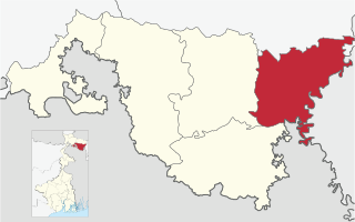
Tufanganj subdivision is a subdivision of the Cooch Behar district in the state of West Bengal, India.

Natabari Assembly constituency is an assembly constituency in Cooch Behar district in the Indian state of West Bengal.

<span class="mw-page-title-main">Cooch Behar I</span> Community development block in West Bengal, India

Cooch Behar I is a community development block that forms an administrative division in the Cooch Behar Sadar subdivision of the Cooch Behar district in the Indian state of West Bengal.

<span class="mw-page-title-main">Dinhata I</span> Community development block in West Bengal, India

Dinhata I is a community development block that forms an administrative division in the Dinhata subdivision of the Cooch Behar district in the Indian state of West Bengal.

<span class="mw-page-title-main">Dinhata II</span> Community development block in West Bengal, India

Dinhata II is a community development block that forms an administrative division in the Dinhata subdivision of the Cooch Behar district in the Indian state of West Bengal.

<span class="mw-page-title-main">Mathabhanga II</span> Community development block in West Bengal, India

Mathabhanga II is a community development block that forms an administrative division in the Mathabhanga subdivision of the Cooch Behar district in the Indian state of West Bengal.

<span class="mw-page-title-main">Tufanganj I</span> Community development block in West Bengal, India

Tufanganj I is a community development block that forms an administrative division in the Tufanganj subdivision of the Cooch Behar district in the Indian state of West Bengal.

<span class="mw-page-title-main">Tufanganj II</span> Community development block in West Bengal, India

Tufanganj-II is a community development block that forms an administrative division in Tufanganj subdivision of Cooch Behar district in the Indian state of West Bengal.

Bamanhat is a neighbourhood and a gram panchayat in the Dinhata II CD block in the Dinhata subdivision of the Cooch Behar district, West Bengal, India.

Gitaldaha is a village and a gram panchayat in the Dinhata I CD block in the Dinhata subdivision of the Cooch Behar district in the state of West Bengal, India.

Ghoksadanga is a neighbourhood and a gram panchayat in the Mathabhanga II CD block in the Mathabhanga subdivision of the Cooch Behar district in the state of West Bengal, India.

Kamat Phulbari is a census town in the Tufanganj I CD block in the Cooch Behar Sadar subdivision of the Cooch Behar district in the state of West Bengal, India.

Natabari is a village and a gram panchayat in the Tufanganj I CD block in the Tufanganj subdivision of the Cooch Behar district in the state of West Bengal, India.

Nakkatigachhi is a village in the Tufanganj I CD block in the Tufanganj subdivision of the Cooch Behar district in West Bengal, India

Bara Kodali is a village and a gram panchayat in the Tufanganj II CD block in the Tufanganj subdivision of the Cooch Behar district in West Bengal, India.

References

  1. "Directory of District, Subdivision, Panchayat Samiti/ Block and Gram Panchayats in West Bengal". Cooch Behar. Retrieved 3 August 2020.
  2. "District Statistical Handbook 2013 Cooch Behar". Tables 2.2, 2.4b. Department of Planning and Statistics, Government of West Bengal. Archived from the original on 21 January 2019. Retrieved 5 August 2020.
  3. "District Census Handbook, Koch Bihar, Series 20, Part XIIA" (PDF). Census of India 2011, pages 17-21 Physical feafures. Directorate of Census Operations, West Bengal. Retrieved 5 August 2020.
  4. "C.D. Block Wise Primary Census Abstract Data(PCA)". West Bengal – District-wise CD Blocks. Registrar General and Census Commissioner, India. Retrieved 3 August 2020.
  5. 1 2 3 4 5 Koch Bihar Jelar Purakirti (in Bengali), Data compilation and writing by Dr. Shyamachand Mukhopadhayay, published by the Department of Archaeology, Government of West Bengal, Second edition 1974, Pages 26-28.