Bara Kodali

Last updated

Bara Kodali
Village
West Bengal location map.svg
Red pog.svg
Bara Kodali
Location in West Bengal, India
India location map.svg
Red pog.svg
Bara Kodali
Bara Kodali (India)
Coordinates: 26°18′16″N89°42′43″E / 26.3045°N 89.7119°E / 26.3045; 89.7119
CountryFlag of India.svg  India
State West Bengal
District Cooch Behar
Population
 (2011)
  Total5,008
Time zone UTC+5:30 (IST)
Telephone/STD code03582
Vehicle registration WB
Lok Sabha constituency Alipurduars
Vidhan Sabha constituency Tufangana
Website coochbehar.gov.in

Bara Kodali is a village and a gram panchayat in the Tufanganj II CD block in the Tufanganj subdivision of the Cooch Behar district in West Bengal, India.

Contents

Geography

Bara Kodali
Places in the Tufanganj and Dinhata subdivisions (except Sitai CD block) in Cooch Behar district
CT: census town, M: municipal town, R: rural/ urban centre, H: historical/ religious centre
Owing to space constraints in the small map, the actual locations in a larger map may vary slightly

Location

Bara Kodali is located at 26°18′16″N89°42′43″E / 26.3045°N 89.7119°E / 26.3045; 89.7119 .

Bara Kodali I and Bara Kodali II are gram panchayats in the Tufanganj II CD block. [1]

Area overview

The map alongside shows the eastern part of the district. In Tufanganj subdivision 6.97% of the population lives in the urban areas and 93.02% lives in the rural areas. In Dinhata subdivision 5.98% of the population lives in the urban areas and 94.02% in the urban areas. [2] The district forms the flat alluvial flood plains of mighty rivers. [3]

Note: The map alongside presents some of the notable locations in the subdivisions. All places marked in the map are linked in the larger full screen map.

Demographics

As per the 2011 Census of India, Bara Kodali had a total population of 5,008. There were 2,574 (51%) males and 2,435 (49%) females. There were 535 persons in the age range of 0 to 6 years. The total number of literate people in Bara Kodali was 3,346 (74.79% of the population over 6 years). [4]

Culture

Dameswar Shiv Mandir is housed in a small structure with a tin roof. The Shiva linga is worshipped as Great Mahadev. Locals believe that the Shiva linga was established here by Sukladwaj or Chilarai, (1510-1571), younger brother of Nara Narayan, of the Koch dynasty . However, there is no trace of the original temple. It is under the Cooch Behar Debuttor Sangstha. [5]

Related Research Articles

Baneswar is a census town in the Cooch Behar II CD block in the Cooch Behar Sadar subdivision of the Cooch Behar district in West Bengal, India.

<span class="mw-page-title-main">Mekhliganj subdivision</span> Subdivision in West Bengal, India

Mekhliganj subdivision is one of five subdivisions of the Cooch Behar district in the state of West Bengal, India. It has an area of 459.78 km2. As of 2011, its population was 282,750, of which 90.09% was rural and 9.91 urban.

<span class="mw-page-title-main">Tufanganj subdivision</span> Subdivision in West Bengal, India

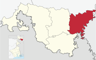
Tufanganj subdivision is a subdivision of the Cooch Behar district in the state of West Bengal, India.

<span class="mw-page-title-main">Cooch Behar II</span> Community development block in West Bengal, India

Cooch Behar II is a community development block that forms an administrative division in the Cooch Behar Sadar subdivision of the Cooch Behar district in the Indian state of West Bengal.

<span class="mw-page-title-main">Dinhata I</span> Community development block in West Bengal, India

Dinhata I is a community development block that forms an administrative division in the Dinhata subdivision of the Cooch Behar district in the Indian state of West Bengal.

<span class="mw-page-title-main">Tufanganj I</span> Community development block in West Bengal, India

Tufanganj I is a community development block that forms an administrative division in the Tufanganj subdivision of the Cooch Behar district in the Indian state of West Bengal.

<span class="mw-page-title-main">Tufanganj II</span> Community development block in West Bengal, India

Tufanganj-II is a community development block that forms an administrative division in Tufanganj subdivision of Cooch Behar district in the Indian state of West Bengal.

Andaranfulbari is a village and a gram panchayat in the Tufanganj I CD block in the Tufanganj subdivision of the Cooch Behar district in West Bengal, India.

Bamanhat is a neighbourhood and a gram panchayat in the Dinhata II CD block in the Dinhata subdivision of the Cooch Behar district, West Bengal, India.

Gitaldaha is a village and a gram panchayat in the Dinhata I CD block in the Dinhata subdivision of the Cooch Behar district in the state of West Bengal, India.

Ghoksadanga is a neighbourhood and a gram panchayat in the Mathabhanga II CD block in the Mathabhanga subdivision of the Cooch Behar district in the state of West Bengal, India.

Sahebganj is a village in the Dinhata II CD block in the Dinhata subdivision of the Cooch Behar district in the state of West Bengal, India.

Chhota Laukuthi is a census town in the Tufanganj II CD block in the Tufanganj subdivision of the Cooch Behar district in the state of West Bengal, India.

Ghughumari is a village and a gram panchayat in the Cooch Behar I CD block in the Cooch Behar Sadar subdivision of the Cooch Behar district in the state of West Bengal, India.

Sitai is a village and gram panchayat in the Sitai CD block in the Dinhata subdivision of the Cooch Behar district in the state of West Bengal, India.

Dhaliabari is a census town in the Cooch Behar I CD block in the Cooch Behar Sadar subdivision of the Cooch Behar district in the state of West Bengal, India.

Kamat Phulbari is a census town in the Tufanganj I CD block in the Cooch Behar Sadar subdivision of the Cooch Behar district in the state of West Bengal, India.

Natabari is a village and a gram panchayat in the Tufanganj I CD block in the Tufanganj subdivision of the Cooch Behar district in the state of West Bengal, India.

Airani Chitalia is a village in the Tufanganj I CD block in the Tufanganj subdivision of the Cooch Behar district in West Bengal, India

Nakkatigachhi is a village in the Tufanganj I CD block in the Tufanganj subdivision of the Cooch Behar district in West Bengal, India

References

  1. "Directory of District, Subdivision, Panchayat Samiti/ Block and Gram Panchayats in West Bengal". Cooch Behar. Retrieved 3 August 2020.
  2. "District Statistical Handbook 2013 Cooch Behar". Tables 2.2, 2.4b. Department of Planning and Statistics, Government of West Bengal. Archived from the original on 21 January 2019. Retrieved 5 August 2020.
  3. "District Census Handbook, Koch Bihar, Series 20, Part XIIA" (PDF). Census of India 2011, pages 17-21 Physical feafures. Directorate of Census Operations, West Bengal. Retrieved 5 August 2020.
  4. "C.D. Block Wise Primary Abstract Data(PCA)". West Bengal – District-wise CD Blocks. Registrar General and Census Commissioner, India. Retrieved 3 August 2020.
  5. Koch Bihar Jelar Purakirti (in Bengali), Data compilation and writing by Dr. Shyamachand Mukhopadhayay, published by the Department of Archaeology, Government of West Bengal, Second edition 1974, Page 56.