Nakkatigachhi

Last updated

Nakkatigachh
Village
West Bengal location map.svg
Red pog.svg
Nakkatigachh
Location in West Bengal, India
India location map.svg
Red pog.svg
Nakkatigachh
Nakkatigachh (India)
Coordinates: 26°16′14″N89°39′20″E / 26.2705°N 89.6556°E / 26.2705; 89.6556
CountryFlag of India.svg  India
State West Bengal
District Cooch Behar
Population
 (2011)
  Total4,243
Time zone UTC+5:30 (IST)
PIN
736159
Telephone/STD code03582
Vehicle registration WB
Lok Sabha constituency Alipurduars
Vidhan Sabha constituency Tufanganj
Website coochbehar.gov.in

Nakkatigachhi is a village in the Tufanganj I CD block in the Tufanganj subdivision of the Cooch Behar district in West Bengal, India

Contents

Geography

Invisible Square.svg
Mapscaleline.svg
8km
5miles
Red pog.svg
A
S
S
A
M
B
A
N
G
L
A
D
E
S
H
Kamteswari
temple
H
Invisible Square.svg
Rajpat
H
Invisible Square.svg
River
Mara Torsha
Gangadhar River
River
Dudhkumar
Dharla River
Nakkatigachhi
H
Chamta
H
Invisible Square.svg
Bhuchungmari
H
Invisible Square.svg
Bara Kodali
H
Invisible Square.svg
Andaranfulbari
H
Invisible Square.svg
Airani Chitalia
H
Invisible Square.svg
Gosanimari
H
Invisible Square.svg
Sahebganj
R
Invisible Square.svg
Gitaldaha
R
Invisible Square.svg
Bamanhat
R
Invisible Square.svg
Natabari
R
Invisible Square.svg
Bakshirhat
R
Invisible Square.svg
Dinhata
M
Invisible Square.svg
Tufanganj
M
Invisible Square.svg
Bhangri
Pratham
Khanda
CT
Invisible Square.svg
Places in the Tufanganj and Dinhata subdivisions (except Sitai CD block) in Cooch Behar district
CT: census town, M: municipal town, R: rural/ urban centre, H: historical/ religious centre
Owing to space constraints in the small map, the actual locations in a larger map may vary slightly

Location

Nakkatgachhi is located at 26°16′14″N89°39′20″E / 26.2705°N 89.6556°E / 26.2705; 89.6556 .

Area overview

The map alongside shows the eastern part of the district. In Tufanganj subdivision 6.97% of the population lives in the urban areas and 93.02% lives in the rural areas. In Dinhata subdivision 5.98% of the population lives in the urban areas and 94.02% lives in the urban areas. [1] The entire district forms the flat alluvial flood plains of mighty rivers. [2]

Note: The map alongside presents some of the notable locations in the subdivisions. All places marked in the map are linked in the larger full screen map.

Demographics

As per the 2011 Census of India, Nakkatigachh had a total population of 4,243. There were 2,213 (52%) males and 2,030 (48%) females. There were 488 persons in the age range of 0 to 6 years. The total number of literate people in Nakkatagachhi was 2,495 (66.44% of the population over 6 years). [3]

Culture

As per local beliefs, Sukladwaj or Chilarai, (1510-1571), younger brother of Nara Narayan, of the Koch dynasty, had established an idol of Sandeswar Shiva in this village. However, it is not clear as to whether he built a temple. Some opinions point to Maharaja Pran Narayan or Najirdeo Khagendra Narayan as builders of the temple, and yet others think that the temple was built by Chilarai, and later modified/ improved upon by Pran Narayan and Khagendra Narayan. It is also possible that the temple was so badly damaged that Khagendra Narayan rebuilt it. The present brick-built temple with a sheet ‘charchala’ is not more than 200–250 years old, but remnants of a broken temple indicate of there being an earlier temple in the traditional Cooch Behar style. The Shiva linga continues to be worshipped daily and this temple is under the Cooch Behar Debuttor Sangstha. [4]

Related Research Articles

<span class="mw-page-title-main">Cooch Behar district</span> District in West Bengal, India

Cooch Behar district is a district of the Indian state of West Bengal.

Bhangri Pratham Khanda is a census town in the Dinhata I CD block in the Dinhata subdivision of the Cooch Behar district in the state of West Bengal, India.

<span class="mw-page-title-main">Dinhata</span> City in West Bengal, India

Dinhata is a city and a municipality in Cooch Behar district in the state of West Bengal, India. It is the headquarters of the Dinhata subdivision. Dinhata is known for arranging one of the best Durga Puja in North Bengal. Dinhata is famous for Sastho Mela and Dinhata Utsav, Sanghati Mela, Janmastami Mela. Apart from the city area, Dinhata consists of 3 blocks.

<span class="mw-page-title-main">Tufanganj</span> Subdivisional Town in West Bengal, India

Tufanganj is a town and a municipality of Cooch Behar district in the Indian state of West Bengal. It is the headquarters of the Tufanganj subdivision.

<span class="mw-page-title-main">Dinhata subdivision</span> Subdivision in West Bengal, India

Dinhata subdivision is a subdivision of the Cooch Behar district in the state of West Bengal, India.

<span class="mw-page-title-main">Tufanganj subdivision</span> Subdivision in West Bengal, India

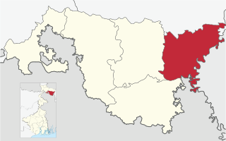
Tufanganj subdivision is a subdivision of the Cooch Behar district in the state of West Bengal, India.

Andaranfulbari is a village and a gram panchayat in the Tufanganj I CD block in the Tufanganj subdivision of the Cooch Behar district in West Bengal, India.

Gosanimari is both a village and an archaeological site in Dinhata I CD block, in the Dinhata subdivision of the Cooch Behar district of West Bengal, north-eastern India. The name of this site was taken from the modern grampanchyat name of the Dinhata subdivision.

Bamanhat is a neighbourhood and a gram panchayat in the Dinhata II CD block in the Dinhata subdivision of the Cooch Behar district, West Bengal, India.

Gitaldaha is a village and a gram panchayat in the Dinhata I CD block in the Dinhata subdivision of the Cooch Behar district in the state of West Bengal, India.

Bakshirhat is a neighbourhood in the Tufanganj II CD block in the Tufanganj subdivision of the Cooch Behar district in the state of West Bengal, India.

Sahebganj is a village in the Dinhata II CD block in the Dinhata subdivision of the Cooch Behar district in the state of West Bengal, India.

Chhota Laukuthi is a census town in the Tufanganj II CD block in the Tufanganj subdivision of the Cooch Behar district in the state of West Bengal, India.

Kamat Phulbari is a census town in the Tufanganj I CD block in the Cooch Behar Sadar subdivision of the Cooch Behar district in the state of West Bengal, India.

Natabari is a village and a gram panchayat in the Tufanganj I CD block in the Tufanganj subdivision of the Cooch Behar district in the state of West Bengal, India.

Airani Chitalia is a village in the Tufanganj I CD block in the Tufanganj subdivision of the Cooch Behar district in West Bengal, India

Chamta is a village in the Tufanganj I CD block in the Tufanganj subdivision of the Cooch Behar district in West Bengal, India

Bhuchungmari is a village in the Tufanganj I CD block in the Tufanganj subdivision of the Cooch Behar district in West Bengal, India

Bara Kodali is a village and a gram panchayat in the Tufanganj II CD block in the Tufanganj subdivision of the Cooch Behar district in West Bengal, India.

Kamteswari temple is at Gosanimari in the Dinhata I CD block in the Dinhata subdivision of the Cooch Behar district in West Bengal, India.

References

  1. "District Statistical Handbook 2013 Cooch Behar". Tables 2.2, 2.4b. Department of Planning and Statistics, Government of West Bengal. Archived from the original on 21 January 2019. Retrieved 5 August 2020.
  2. "District Census Handbook, Koch Bihar, Series 20, Part XIIA" (PDF). Census of India 2011, pages 17-21 Physical feafures. Directorate of Census Operations, West Bengal. Retrieved 5 August 2020.
  3. "C.D. Block Wise Primary Abstract Data(PCA)". West Bengal – District-wise CD Blocks. Registrar General and Census Commissioner, India. Retrieved 3 August 2020.
  4. Koch Bihar Jelar Purakirti (in Bengali), Data compilation and writing by Dr. Shyamachand Mukhopadhayay, published by the Department of Archaeology, Government of West Bengal, Second edition 1974, Page 52