According to many references, the name Panskura have been originated from the word "Panchkoora". The king of Kasijora once gave some land to the poet Nityanand Chakrabarty at the time of his 'Diksha'. This evidence is found in the book of Manikram Gangopadhyay's 'Shitala Mangal' – 'Panchakurya jami dilo karya bramhottar'. The meaning of 'Pancha' is five and 'kurya' means the amount of land situated in a river valley. It is actually a Persi term. The name 'Panskura' has come from this 'Panchakurya' through evolution.[2] Like the term Kenjakura in Bankura which is also a place situated near a river Dwarkeswar.
'East India Irrigation and Canal Company', in 1852, dug Midnapur Canal for the cultivation, communication and trade from Uluberia to Mohanpur,. According to Regional History researcher Shyamal Bera, "The steamers transported through the Midnapore canal and came to Kangsabati (now South Gopalpur Mouza) and used to throw 'Pans' [ashes] and collects 'Kura' [fuel]. Since then, the name of the area seems to have been formed into Panskua [Pans+Kura]."
There is a mention of 'Punchcoora School' in English at Panskura Bradley Birt High School's guards' badge which was established in 1864 at Sadarghat, Panskura. In addition, during the British period, the collector Bailey Sahib of Midnapore told about Kansabati coastal area in his written 'Memoranda of Midnapur' in 1852. This area is referred to as 'Panchkura Ghat'. Later, the name of the entire Kasijora pargana was changed to the name of Panskura. Panskura Ghat does not exist anymore. However, the area adjoining lock-gate which was built 1896 is still known as Sadar Ghat. The present-day Old Panskura was formed adjoining the area of Sadar Ghat.
According to some people the name of Panskura came from Pashangara. Because of irrigation in the past, Lockh-gate or 'Pashang' was built in this area of Midnapore Canal. The place adjacent to the lock-gate was called 'Pashangara'. The name 'Panskura' came from this 'Pasangara'.[3]
Geography
8km 5miles
H
Purbba Gopalpur
H
Dakshin Maynadal
W
Rupnarayan
R
Bhabanipur
R
Chak Srikrishnapur
R
Chandipur
R
Nandakumar
R
Moyna
R
Janu Basan
R
Uttar Mechogram
R
Shyamsundarpur Patna
R
Chatara
CT
Erashal
CT
Kotbar
CT
Goasafat
CT
Dakshin Baguan
CT
Anantapur
CT
Shantipur
CT
Kakdihi
CT
Kharisha
CT
Mihitikri
CT
Amalhara
CT
Kolaghat
M
Panskura
M
Tamluk
Cities and towns in Tamluk subdivision of Purba Medinipur district M: municipal city/ town, CT: census town, R: rural/ urban centre, H: historical/ religious centre Owing to space constraints in the small map, the actual locations in a larger map may vary slightly
The climate follows a hot tropical monsoon weather pattern. Summers last from mid-April to mid-June with diurnal highs ranging from the upper 30s °C to the mid-40s °C and lows in the low 30s°C in the winter. In summer daily heat is often followed by evening rains known as kalboishakhis or dust-storms (loo). Monsoon rains can last from mid-June to late August with rains from the southeast monsoon contributing the lion's share of the annual rainfall of around 1600mm. Winters last for 2 to 3 months and are mild; typical lows are from 6°C – 14°C. Panskura has considerably lesser particulate pollution due its comparatively lesser and satisfactory air quality index.
Urbanisation
94.08% of the population of Tamluk subdivision live in the rural areas. Only 5.92% of the population live in the urban areas, and that is the second-lowest proportion of urban population amongst the four subdivisions in Purba Medinipur district, just above Egra subdivision.[5]
Note: The map alongside presents some of the notable locations in the subdivision. All places marked in the map are linked in the larger full screen map.
Demographics
As per 2011 Census of India Panskura had a total population of 57,932 of which 29,740 (51%) were males and 28,192 (49%) were females. Population below 6 years was 6,943. The total number of literates in Panskura was 43,326 (84.97% of the population over 6 years).[6]
Panskura police station has jurisdiction over Panskura (municipality) and Panskura CD Block. Panskura police station covers an area of 285km2 with a population of 350,000.[8][9]
Economy
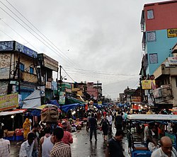
The livelihood of the common people is dependent on Business/Job/Agriculture. Many varieties of flowers and green vegetable are grown and are supplied to Kolkata from here. Local vegetable wholesale market is the main trade of this town. This vegetable market is the 2nd largest market in West Bengal. The first governmental cold storage & market for flower is situated at Panskura.
Panskura Bazaar
A large portion of the local population are farmers. Vegetables produced by farmers come to the bazaar, a busy and large wholesale market. It is the supply line for the vegetable markets of Kolkata and its outskirts. The bazaar is also well connected by train and road (NH6) to Kolkata which is the nearest big city. Local trains of South Eastern Line are frequent. Kharagpur, Haldia and Digha train connection is also available here.
Cuisine
Panskura is famous for its popular Panskurar Chop (Panskurar aloor chop)[10] made out of boiled potatoes, besan (gram flour) (khaasareer daal) and various spices. It is popular for its famous muger jilipi.
Education
British English Institute Panskura (Spoken English learning center where teachers are foreigners)
Panskura Banamali College Autonomous (both undergraduate and postgraduate degree in arts and science) is the sole institution of higher education.
Kumarpur Hateswar High School [Gov. Sponsored], Estd- 5 Feb 1947
Usatpur soudamini Vidya Mandir (H.S)- (1965)
Health
There is a Government Super Speciality Hospital and a Private Super Speciality Hospital and some Private Nursing Homes in Panskura. People of this area mainly depend on that hospitals and nursing homes.
Panskura Super Speciality Hospital ( Governmental )
Baroma Sirona Hospital ( Super Speciality )
Jivandeep Nursing Home
IDAN Nursing Home
Subhalaxmi Nursing Home
Mother Teresa Nursing Home
New Mother Teresa Nursing Home
Life Care Nursing Home
Vivekananda Nursing Home
Astha Nursing Home
Ashalata Nursing Home
Tourism
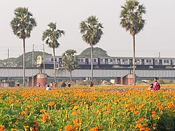
Panskura CD block is known for its Valley of Flowers, Kingdom of Flower and Gladiolas garden which is situated near Khirai railway station and Kansabati river. The river Kansabati is a good picnic spot and Bhavatarini Shmashanpith Kali Temple nearby old Panskura bazar is a pilgrimage spot. Gosaibaba Samadhi Mandir and Begunbari Kali Temple in Khirai are also a popular pilgrimage spot.[11]
Transportation
Panskura is well connected by train and road (NH16) to Kolkata which is the nearest big city. Local trains of South Eastern Line are frequently available at Panskura railway station. Kharagpur, Haldia and Digha train connection are also available.
Kolkata is also well connected to Panskura by NH 16. Local buses, Trakers, Toto and private taxis also play a major role of transportation to more interior villages from there. SH 4 passes through Panskura.
Panskura is well connected to Ghatal by bus from Panskura bus stand and bus from Kolkata to Ghatal is also have to pass from panskura near machogram. Panskura is also connected to district town Tamluk by bus & train.
↑"District Statistical Handbook 2014 Purba Medinipur". Tables 2.1, 2.2. Department of Statistics and Programme Implementation, Government of West Bengal. Archived from the original on 29 July 2017. Retrieved 10 November 2016.
↑"Panskura PS". Purba Medinipur District. Retrieved 10 November 2016.
This page is based on this Wikipedia article Text is available under the CC BY-SA 4.0 license; additional terms may apply. Images, videos and audio are available under their respective licenses.