Basantia

Last updated

Basantia
Village
West Bengal location map.svg
Red pog.svg
Basantia
Location in West Bengal, India
India location map 3.png
Red pog.svg
Basantia
Basantia (India)
Coordinates: 21°48′05″N87°48′07″E / 21.801267°N 87.801846°E / 21.801267; 87.801846
CountryFlag of India.svg  India
State West Bengal
District Purba Medinipur
Area
  Total1.3479 km2 (0.5204 sq mi)
Population
 (2011)
  Total5,455
  Density4,000/km2 (10,000/sq mi)
Languages
  Official Bengali, English
Time zone UTC+5:30 (IST)
PIN
721442 (Basantia)
Telephone/STD code03220
Lok Sabha constituency Kanthi
Vidhan Sabha constituency Kanthi Uttar
Website purbamedinipur.gov.in

Basantia is a census town and gram panchayat in Deshapran CD block in Contai subdivision of Purba Medinipur district in the state of West Bengal, India.

Contents

Geography

Basantia
Invisible Square.svg
Mapscaleline.svg
8km
5miles
Red pog.svg
W
e
s
t
B
e
n
g
a
l
O
d
i
s
h
a
B
a
y
o
f
B
e
n
g
a
l
Jukhia
H
Invisible Square.svg
Dariapur
R
Invisible Square.svg
Dihibahiri
H
Invisible Square.svg
Petuaghat
Fishing Harbour
S
Invisible Square.svg
Junput
S
Invisible Square.svg
Mandarmani
SV
Invisible Square.svg
Tajpur Port
S
Invisible Square.svg

Shankarpur
S
Invisible Square.svg
New Digha
S
Invisible Square.svg
Kharipukuria
R
Invisible Square.svg
Silaberia
R
Invisible Square.svg
Depal
R
Invisible Square.svg
Durmut
R
Invisible Square.svg
Baratala
R
Invisible Square.svg
Dholmari
R
Invisible Square.svg
Bara Bankuya
R
Invisible Square.svg
Janka
R
Invisible Square.svg
Kamarda
R
Invisible Square.svg
Khejuri
R
Invisible Square.svg
Majna
R
Invisible Square.svg
Bhupatinagar
R
Invisible Square.svg
Marishda
R
Invisible Square.svg
Ramnagar
R
Invisible Square.svg
Digha
R
Invisible Square.svg
Khadalgobra
CT
Invisible Square.svg
Basantia
CT
Cities and towns in Contai subdivision of Purba Medinipur district
M: municipal city/ town, CT: census town, R: rural/ urban centre, H: historical/ religious centre, S: port, sea-beach
Owing to space constraints in the small map, the actual locations in a larger map may vary slightly

Location

Basantia is located at 21°48′05″N87°48′07″E / 21.801267°N 87.801846°E / 21.801267; 87.801846 .

Urbanisation

93.55% of the population of Contai subdivision live in the rural areas. Only 6.45% of the population live in the urban areas and it is considerably behind Haldia subdivision in urbanization, where 20.81% of the population live in urban areas. [1]

Note: The map alongside presents some of the notable locations in the subdivision. All places marked in the map are linked in the larger full screen map.

Demographics

As per 2011 Census of India Basantia had a total population of 5,455 of which 2,843 (52%) were males and 2,612 (48%) were females. Population below 6 years was 700. The total number of literates in Basantia was 3,749 (78.84% of the population over 6 years). [2]

Religious Significance

The village has the famous temple of Sri Sri Gokul Chandra Rai Thakur. This temple was established by one Baikuntha Deb Goswami more than 250 years ago. He received a Zamindari grant of 7200 bighas of land to help with the services of the temple.

Since 1933, on the basis of an order of the Honourable High Court of Calcutta, the descendants of Rai Radha Shyam Das Adhikary Bahadur are continuing as Shebait and Mahanta of the temple.

They organise the famous RAS Utsav at the temple during the month of Kartik.

Infrastructure

As per the District Census Handbook 2011, Basantia covered an area of 1.3479 km2. It had the facility of a railway station at Contai 12 km away and bus routes in the town. Amongst the civic amenities it had 100 road lighting points and 1,120 domestic electric connections. Amongst the medical facilities it had a hospital and 8 medicine shops in the town. Amongst the educational facilities it had were 2 primary schools, 2 secondary schools and a senior secondary school. The nearest degree college was at Contai. [3]

Transport

Basantia is on Contai-Basantia-Benichak-Rasulpur Road. [4]

Education

Basantia High School is a coeducational higher secondary school. [5]

Daruya Gandhi Smriti High School is a Bengali-medium coeducational school established in 1972. [6]

Healthcare

Basantia Rural Hospital at Basantia (with 30 beds) is the main medical facility in Deshapran CD block. There are primary health centres at Barabantalia (with 15 beds) and Daulatpur, PO Dariapur (with 10 beds). [7]

Related Research Articles

Majna is a village in Contai I CD block in Contai subdivision of Purba Medinipur district in the state of West Bengal, India.

<span class="mw-page-title-main">Contai</span> City in West Bengal, India

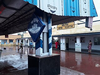
Contai popularly known as Kanthi is a coastal and subdivisional city and a municipality in Purba Medinipur district, West Bengal, India. It is the headquarters of the Contai subdivision.

<span class="mw-page-title-main">Contai subdivision</span> Sub District in West Bengal, India

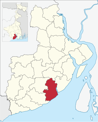
Contai Subdivision is a subdivision of the Purba Medinipur district in the state of West Bengal, India.

<span class="mw-page-title-main">Deshapran (community development block)</span> Community development block in West Bengal, India

Deshapran is a community development block that forms an administrative division in Contai subdivision of Purba Medinipur district in the Indian state of West Bengal.

Janka is a village, in Khejuri II CD block in Contai subdivision of Purba Medinipur district in the state of West Bengal, India. Khejuri police station is located at Janka.

Kamarda is a village, in Khejuri I CD block in Contai subdivision of Purba Medinipur district in the state of West Bengal, India.

Bhupatinagar is a village, in Bhagabanpur II CD block in Contai subdivision of Purba Medinipur district in the state of West Bengal, India.

Marishda is a village, in Contai III CD block in Contai subdivision of Purba Medinipur district in the state of West Bengal, India.

<span class="mw-page-title-main">Ramnagar, Purba Medinipur</span> Township in West Bengal, India

Ramnagar is a Township Area, in Ramnagar I CD block in Contai subdivision of Purba Medinipur district in the state of West Bengal, India.

Bara Bankuya is a village, in Ramnagar II CD block in Contai subdivision of Purba Medinipur district in the state of West Bengal, India.

Dholmari is a village, in Deshapran CD block in Contai subdivision of Purba Medinipur district in the state of West Bengal, India.

Durmut is a village, in Contai 3 CD Block in Contai subdivision of Purba Medinipur district in the state of West Bengal, India.

Junput is a village in Deshapran CD Block in Contai subdivision of Purba Medinipur district in the state of West Bengal, India.

Baratala is a village and a gram panchayat, in Khejuri II CD Block in Contai subdivision of Purba Medinipur district in the state of West Bengal, India.

Silaberia is a village in Khejuri II CD block in Contai subdivision of Purba Medinipur district in the state of West Bengal, India.

Kharipukuria is a village in Contai III CD block in Contai subdivision of Purba Medinipur district in the state of West Bengal, India.

Khadalgobra is a census town in Ramnagar I CD block in Contai subdivision of Purba Medinipur district in the state of West Bengal, India.

Dihibahiri is a village in the Contai III CD block in the Contai subdivision of the Purba Medinipur district in the state of West Bengal, India.

Dariapur is a village in the Deshapran CD block in the Contai subdivision of the Purba Medinipur district in the state of West Bengal, India.

Jukhia is a village and a gram panchayat in the Bhagabanpur II CD block in the Contai subdivision of the Purba Medinipur district in the state of West Bengal, India.

References

  1. "District Statistical Handbook 2014 Purba Medinipur". Table 2.2. Department of Planning and Statistics, Government of West Bengal. Archived from the original on 21 January 2019. Retrieved 22 April 2019.
  2. "2011 Census – Primary Census Abstract Data Tables". West Bengal – District-wise. Registrar General and Census Commissioner, India. Retrieved 2 April 2019.
  3. "District Census Handbook Purba Medinipur, Census of India 2011, Series 20, Part XII A" (PDF). Section II Town Directory, Statement I: Growth History, Pages 1207-1209; Statement II: Physical Aspects and Location of Towns, Page 1210; Statement III: Civic and other Amenities, Pages 1211-1212; Statement IV: Medical Facilities 2009, Pages 1212-1213; Section: Educational, Recreational and Cultural Facilities, Pages 1213-1215. Directorate of Census Operations, West Bengal. Retrieved 7 April 2019.
  4. Google maps
  5. "Basantia High School". WBCHSE. Retrieved 7 April 2019.
  6. "Daruya Gandhi Smriti High School". OurSchool.In. Retrieved 7 April 2019.
  7. "Health & Family Welfare Department". Health Statistics. Government of West Bengal. Archived from the original on 28 October 2021. Retrieved 27 March 2019.