Mandarmani

Last updated

Mandarmoni
Mandarmani Sea Beach.jpg
Mandarmani Sea Beach
West Bengal location map.svg
Red pog.svg
Mandarmoni
Location in West Bengal, India
India location map.svg
Red pog.svg
Mandarmoni
Mandarmoni (India)
Coordinates: 21°39′58″N87°42′18″E / 21.666°N 87.705°E / 21.666; 87.705
CountryFlag of India.svg  India
State West Bengal
District East Medinipur
Government
  Body Gram panchayat
Area
  Total24.36 km2 (9.41 sq mi)
Population
 (2011)
  Total12,307
  Density492/km2 (1,270/sq mi)
Languages
  Official Bengali, English
Time zone UTC+5:30 (IST)
ISO 3166 code IN-WB
Vehicle registration WB
Nearest city Kolkata
Sex ratio 976 /
Literacy65%
Climate average (Köppen)

Mandarmani is a seaside resort village in the state of West Bengal, India, and lies in East Midnapore district, at the northern end of the Bay of Bengal. It is one of the largest seaside resorts of West Bengal, fast-developing.

Contents

Geography

Mandarmani
Invisible Square.svg
Mapscaleline.svg
8km
5miles
W
e
s
t
B
e
n
g
a
l
O
d
i
s
h
a
B
a
y
o
f
B
e
n
g
a
l
Jukhia
H
Invisible Square.svg
Dariapur
R
Invisible Square.svg
Dihibahiri
H
Invisible Square.svg
Petuaghat
Fishing Harbour
S
Invisible Square.svg
Junput
S
Invisible Square.svg
Mandarmani
SV
Tajpur Port
S
Invisible Square.svg

Shankarpur
S
Invisible Square.svg
New Digha
S
Invisible Square.svg
Kharipukuria
R
Invisible Square.svg
Silaberia
R
Invisible Square.svg
Depal
R
Invisible Square.svg
Durmut
R
Invisible Square.svg
Baratala
R
Invisible Square.svg
Dholmari
R
Invisible Square.svg
Bara Bankuya
R
Invisible Square.svg
Janka
R
Invisible Square.svg
Kamarda
R
Invisible Square.svg
Khejuri
R
Invisible Square.svg
Majna
R
Invisible Square.svg
Bhupatinagar
R
Invisible Square.svg
Marishda
R
Invisible Square.svg
Ramnagar
R
Invisible Square.svg
Digha
R
Invisible Square.svg
Khadalgobra
CT
Invisible Square.svg
Basantia
CT
Invisible Square.svg
Cities and towns in Contai subdivision of Purba Medinipur district
M: municipal city/ town, CT: census town, R: rural/ urban centre, H: historical/ religious centre, S: port, sea-beach
Owing to space constraints in the small map, the actual locations in a larger map may vary slightly

Location

It is almost 172 km from Kolkata Airport on the Kolkata - Digha route. Red crabs crawling around the 13 km long beach is a special attraction of Mandarmani. It was argued to be the longest driveable (drive in) beach in India. [1] [2] It is located under Contai Sub division area.

Geomorphologically, this area has relatively low waves than nearer tourist beach of Digha. However still this beach is deposition with formation of neo dunes in several areas specially around Dadanpatrabar.

Etymology

Initially, after its discovery, this beach was named Mandarboni and also Madar Mani. But with time it came to be known as Mandarmani. [1]

Transportation

Mandarmani can be best reached by road, however local police currently restricts private cars to drive across the beach. A proper road has been built allowing tourists to reach their hotels from the backside.

By train

The nearest railway station is Contai (17 km) and Ashapurna Devi railway station and the nearest airport is Kolkata. [3] There are also multiple buses running every half-hour from 7 am till 6 pm.

By car

From Kolkata, after crossing the Vidyasagar Setu, Kona Expressway leads to Mumbai Road. As the total drive takes about 3.5–4 hours from Kolkata via Kolaghat and Nandakumar. From Nandakumar there is a right turn towards Contai. In the said Kolkata- Digha highway there is stoppage named Chawalkhola where a left side village road ends at a sea-side village called Mandarmani.

There are two toll plazas on the route at Dhulagori and Sonapetya.

Activities

The beach is the primary attraction offering tourists to enjoy the sea from early morning to late afternoon. From 3 PM onwards, people head out nearer resorts where beach bikes, ropeway etc. can be availed. There are also a string of local shops selling shells, handmade jewellery and handicrafts. A few locals also offer groups to take trip towards the mohana (Estuary) during sunset.

Related Research Articles

<span class="mw-page-title-main">Purba Medinipur district</span> District in West Bengal, India

Purba Medinipur district is an administrative unit in the Indian state of West Bengal. It is the southernmost district of Medinipur division – one of the five administrative divisions of West Bengal. The headquarters in Tamluk. It was formed on 1 January 2002 after the Partition of Medinipur into Purba Medinipur and Paschim Medinipur which lies at the northern and western border of it. The state of Odisha is at the southwest border; the Bay of Bengal lies in the south; the Hooghly river and South 24 Parganas district to the east; Howrah district to the north-east; Paschim Medinipur district to the west.

Majna is a village in Contai I CD block in Contai subdivision of Purba Medinipur district in the state of West Bengal, India.

<span class="mw-page-title-main">Digha</span> Seaside resort town in West Bengal, India

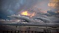
Digha is a seaside resort town in the state of West Bengal, India. It lies in Purba Medinipur district and at the northern end of the Bay of Bengal. It has a low gradient with a shallow sand beach. It is a popular sea resort in West Bengal.

<span class="mw-page-title-main">Contai</span> City in West Bengal, India

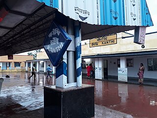
Contai popularly known as Kanthi is a coastal and subdivisional city and a municipality in Purba Medinipur district, West Bengal, India. It is the headquarters of the Contai subdivision.

<span class="mw-page-title-main">Shankarpur</span> Rural in West Bengal, India

Shankarpur is a beach village located 14 km east of Digha in West Bengal, India. It is also a regular fishing harbour. Shankarpur contains a number of temples.

Chaumukha is a coastal village in Baliapal block of Baleswar district of the Indian state of Odisha.

<span class="mw-page-title-main">Tajpur, West Bengal</span> Seaside tourist spot in West Bengal, India

Tajpur is located in Purba Medinipur, in the state of West Bengal, India on the shore of Bay of Bengal. Tajpur is set between Mandarmani and Shankarpur. Tajpur is 172.9 km via NH16 and NH116B from the state capital Kolkata. It is located under Contai Sub division area.

Khejuri is a village and gram panchayat, in Khejuri II CD Block in Contai subdivision of Purba Medinipur district in the state of West Bengal, India.

Kamarda is a village, in Khejuri I CD block in Contai subdivision of Purba Medinipur district in the state of West Bengal, India.

<span class="mw-page-title-main">Ramnagar, Purba Medinipur</span> Township in West Bengal, India

Ramnagar is a Township Area, in Ramnagar I CD block in Contai subdivision of Purba Medinipur district in the state of West Bengal, India.

Durmut is a village, in Contai 3 CD Block in Contai subdivision of Purba Medinipur district in the state of West Bengal, India.

Junput is a village in Deshapran CD Block in Contai subdivision of Purba Medinipur district in the state of West Bengal, India.

Baratala is a village and a gram panchayat, in Khejuri II CD Block in Contai subdivision of Purba Medinipur district in the state of West Bengal, India.

<span class="mw-page-title-main">Petuaghat Fishing Harbour</span> Port in India

Petuaghat Fishing Harbour is a fishing harbour established near the mouth of the Rasulpur River at Petuaaghat in East Midnapore district of West Bengal. The port was inaugurated in 2010 by the then Governor of West Bengal, M. K. Narayanan. The port has been developed in 11.8 hectares of land. The port is India's seventh largest fishing port. The port has 400 deep sea fishing trawlers and 200 traditional trawlers. There is also one ice mill, an ice house, a fake fabric center, and a trailer oil sales center at the port. A trailer repair center has also been proposed to be built.

Kharipukuria is a village in Contai III CD block in Contai subdivision of Purba Medinipur district in the state of West Bengal, India.

Basantia is a census town and gram panchayat in Deshapran CD block in Contai subdivision of Purba Medinipur district in the state of West Bengal, India.

Khadalgobra is a census town in Ramnagar I CD block in Contai subdivision of Purba Medinipur district in the state of West Bengal, India.

Dihibahiri is a village in the Contai III CD block in the Contai subdivision of the Purba Medinipur district in the state of West Bengal, India.

Dariapur is a village in the Deshapran CD block in the Contai subdivision of the Purba Medinipur district in the state of West Bengal, India.

Jukhia is a village and a gram panchayat in the Bhagabanpur II CD block in the Contai subdivision of the Purba Medinipur district in the state of West Bengal, India.

References

  1. 1 2 "West Bengal Tourism, Digha". Archived from the original on 9 February 2012. Retrieved 20 December 2012.
  2. "Mandarmani, A complete travel guide" . Retrieved 20 December 2012.
  3. "Mandarmani" . Retrieved 20 December 2012.