
Purba Medinipur district is an administrative unit in the Indian state of West Bengal. It is the southernmost district of Medinipur division – one of the five administrative divisions of West Bengal. The headquarters in Tamluk. It was formed on 1 January 2002 after the Partition of Medinipur into Purba Medinipur and Paschim Medinipur which lies at the northern and western border of it. The state of Odisha is at the southwest border; the Bay of Bengal lies in the south; the Hooghly river and South 24 Parganas district to the east; Howrah district to the north-east; Paschim Medinipur district to the west.

Ramnagar I is a community development block that forms an administrative division in Contai subdivision of Purba Medinipur district in the Indian state of West Bengal.

Bhagabanpur I is a community development block that forms an administrative division in Egra subdivision of Purba Medinipur district in the Indian state of West Bengal.

Tamluk subdivision is a subdivision of the Purba Medinipur district in the state of West Bengal, India. It under Burdwan division.
Sabang is a community development block that forms an administrative division in the Kharagpur subdivision of Paschim Medinipur district in the Indian state of West Bengal.

Chandipur is a community development block that forms an administrative division in Tamluk subdivision of Purba Medinipur district in the Indian state of West Bengal.

Patashpur I is a community development block that forms an administrative division in Egra subdivision of Purba Medinipur district in the Indian state of West Bengal.

Moyna is a community development block that forms an administrative division in Tamluk subdivision of Purba Medinipur district in the Indian state of West Bengal.

Nandakumar is a community development block that forms an administrative division in Tamluk subdivision of Purba Medinipur district in the Indian state of West Bengal.

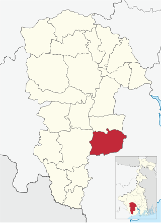
Tamluk is a community development block that forms an administrative division in Tamluk subdivision of Purba Medinipur district in the Indian state of West Bengal.

Panskura is a community development block that forms an administrative division in Tamluk subdivision of Purba Medinipur district in the Indian state of West Bengal.
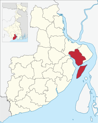
Haldia is a community development block that forms an administrative division in Haldia subdivision of Purba Medinipur district in the Indian state of West Bengal. In earlier days this block was referred to as Sutahata II block, and Sutahata block was referred to as Sutahata I block.

Egra I is a community development block that forms an administrative division in Egra subdivision of Purba Medinipur district in the Indian state of West Bengal.

Egra II is a community development block that forms an administrative division in Egra subdivision of Purba Medinipur district in the Indian state of West Bengal.

Contai I is a community development block that forms an administrative division in Contai subdivision of Purba Medinipur district in the Indian state of West Bengal.

Contai III is a community development block that forms an administrative division in Contai subdivision of Purba Medinipur district in the Indian state of West Bengal.

Khejuri I is a community development block that forms an administrative division in Contai subdivision of Purba Medinipur district in the Indian state of West Bengal.

Ramnagar II is a community development block that forms an administrative division in Contai subdivision of Purba Medinipur district in the Indian state of West Bengal.
Shipur is a fast growing village under Egra I community development block of Purba Medinipur district in the state of West Bengal, India. Famous for its annual Charak Puja, this village has well-developed social facilities like schools, post office, market, co-operative society, telecommunication, ATM, playground, children's park etc. A health centre is also functioning in this village. As per Constitution of India and Panchayati Raj Act, Shipur village is administrated by Sarpanch who is the elected representative of village. Shipur is under the administration of Sahara Gram Panchayat.
Chaita is a village and a gram panchayat in Basirhat II CD Block in Basirhat subdivision of North 24 Parganas district, West Bengal, India with total 528 families residing. The Chaita village has population of 2390 of which 1215 are males while 1175 are females as per population census 2011.

