Kolaghat

Last updated

Kolaghat
Kola
Census Town
BHilsa123.jpg
Kolaghat Thermal Power Station - WBPDCL - East Midnapore 2015-05-01 8584.JPG
Pkner.png
Kolaghat Rail Station Img.jpg
Khway.jpg
Kolaghat Thermal Power Plant High School.jpg
Kola Union High School.jpg
KOLA UNION JOGENDRA GIRLS' HIGH SCHOOL.jpg
KTIGP.jpg
Imhfg.jpg
Pic4 b.jpg
West Bengal location map.svg
Red pog.svg
Kolaghat
Kolaghat(কোলাঘাট) (West Bengal)
India location map 3.png
Red pog.svg
Kolaghat
Kolaghat (India)
Coordinates: 22°26′N87°52′E / 22.43°N 87.87°E / 22.43; 87.87
Country Flag of India.svg  India
State Flag placeholder.svg West Bengal
District Purba Medinipur
Subdivision Tamluk
CD block Kolaghat
Area
  Total6.07 km2 (2.34 sq mi)
  Rank5th
Elevation
9 m (30 ft)
Population
 (2011)
  Total25,191
  Density4,200/km2 (11,000/sq mi)
Languages
  Official Bengali, English
Time zone UTC+5:30 (IST)
PIN
721134 (Kolaghat)
03228721134 (Kolaghat)
ISO 3166 code IN-WB
Vehicle registration WB-29, WB-30,
Lok Sabha constituency Tamluk
Vidhan Sabha constituency Panskura Purba
Avg. summer temperature50 °C (122 °F)
Avg. winter temperature19 °C (66 °F)
Website purbamedinipur.gov.in

Kolaghat is a census town in Kolaghat CD Block, [1] Tamluk subdivision of the Purba Medinipur district in the state of West Bengal, India.

Contents

Geography

Invisible Square.svg
Mapscaleline.svg
8km
5miles
Red pog.svg
Purbba Gopalpur
H
Invisible Square.svg
Dakshin Maynadal
H
Invisible Square.svg
Rupnarayan
Bhabanipur
RV
Invisible Square.svg
Chak Srikrishnapur
R
Invisible Square.svg
Chandipur
R
Invisible Square.svg
Nandakumar
R
Invisible Square.svg
Moyna
R
Invisible Square.svg
Janu Basan
R
Invisible Square.svg
Uttar Mechogram
R
Invisible Square.svg
Shyamsundarpur Patna
R
Invisible Square.svg
Chatara
R
Invisible Square.svg
Erashal
CT
Invisible Square.svg
Kotbar
CT
Invisible Square.svg
Goasafat
CT
Invisible Square.svg
Dakshin Baguan
CT
Invisible Square.svg
Anantapur
CT
Invisible Square.svg
Shantipur
CT
Invisible Square.svg
Kakdihi
CT
Invisible Square.svg
Kharisha
CT
Invisible Square.svg
Mihitikri
CT
Invisible Square.svg
Amalhara
CT
Invisible Square.svg
Kolaghat
CT
Cities and towns in Tamluk subdivision of Purba Medinipur district
M: municipal city/ town, CT: census town, R: rural/ urban centre, H: historical/ religious centre
Owing to space constraints in the small map, the actual locations in a larger map may vary slightly

Location

Kolaghat is located at 22°26′N87°52′E / 22.43°N 87.87°E / 22.43; 87.87 . [2] It is located in the PanskuraII community development block of the Tamluk subdivision. [3]

Police station

Kolaghat police station, situated inside Kolaghat Thermal Power Station has jurisdiction over Kolaghat and Sahid Matangini CD Blocks. [4] [5]

Urbanisation

94.08% of the population of Tamluk subdivision live in the rural areas. Only 5.92% of the population live in the urban areas, and that is the second lowest proportion of urban population amongst the four subdivisions in Purba Medinipur district, just above Egra subdivision. [6] Note: The map alongside presents some of the notable locations in the subdivision. All places marked in the map are linked in the larger full screen map.

Infrastructure

As per the District Census Handbook 2011, Kolaghat covered an area of 6.07 km2. It had the facility of a railway station and bus route. Amongst the medical facilities it had a hospital 4 km away, a nursing home 2 km away, 2 dispensaries/ health centres and 3 medicine shops. Amongst the educational facilities It had were 12 primary schools, 2 middle schools, 2 secondary schools and 2 senior secondary schools. Amongst the recreational and cultural facilities it had were a stadium, a cinema theatre at Mecheda 5 km away, an auditorium/ community hall, a public library and a reading room in the town. [7]

Demographics

As per 2011 Census of India Kolaghat had a total population of 25,191 of which 12,890 (51%) were males and 12,301 (49%) were females. Population below 6 years was 2,349. The total number of literates in Kolaghat was 19,909 (87.16% of the population over 6 years). [8]

As of 2001 India census, [9]  Kolaghat had a population of 23707. Males constitute 51% of the population and females 49%. Kolaghat has an average literacy rate of 71%, higher than the national average of 59.5%: male literacy is 78%, and female literacy is 64%. In Kolaghat, 11% of the population is under 6 years of age.

Civic administration and utility services

Kolaghat Census Town looks after civic affairs in the town. There is a proposal to upgrade it to a Municipality after including the railway area under its jurisdiction. As of now responsibility of civic amenities in railway area lies with the Divisional Railway Master, South Eastern Rly. Division who is also the head of railway establishment in Kolaghat. State-owned Bharat Sanchar Nigam Limited, or BSNL, as well as private enterprises, among them Vodafone-idea(Vi), Airtel, Jio and are the leading telephone, cell phone and internet service providers in the city.

Economy and industry

The riverside has become a popular picnic spot and is often crowded with people, particularly during the Christmas and New Year holidays. The town is notable for its Hilsa fish.

Post Office

The Railway Station

South Eastern Railway Zone

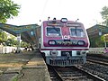
One of the key features of Kolaghat is its railway station. It is by far the busiest railway station in South Eastern Railway Zone within West Bengal due to its connectivity to other major places:5 of Platforms:3.

Transport

Kolaghat is well connected by road through NH-116 and NH-6 (namely Bombay road). It is 54.4 km from Kolkata and 60.45 km from Kharagpur. The Kolaghat Bridge (Namely Sarat Setu) is the only which connects the South India. [12]

Education

Colleges and schools

Notable people

Healthcare

Paikpari Rural Hospital at Paikpari, PO Kolaghat (with 30 beds) is the main medical facility in Kolaghat. A few private nursing homes and clinics are spread across all over Kolaghat. Many renowned doctors visit several clinics on a regular basis. There are primary health centres at Machinan, PO Gopalnagar (with 6 beds) & Nandaigajan, PO Bhogpur (with 10 beds). [13]

Culture

Bengali is the main language here. Places of worship include Kolaghat Jain Temple, Shiva Temple, Shitala Temple in Old Bazar, Mosque, Gopalnagar Vrindavan Temple, Kanak Durga Temple, Rain Kalindakunj Temple, Jagannath Temple, Jashar Panchananda Shiva Temple, the most famous festivals here are Ul Fitr, Kartik Puja, Saraswati Puja, Shab-i-Barat, Kali Puja, Muharram, Barah Wafat and others. It is the biggest festival of all. A number of books ("Kolaghat Sanket" in Bengali), Rupnarayan and Kolaghat festival are being held here. There should also be a reporting flower fair ("flower fair" in Bengali).

Related Research Articles

Dakshin Baguan is a census town in Tamluk CD Block in Purba Medinipur district in the state of West Bengal, India.

Goasafat is a census town in Moyna CD Block in Purba Medinipur district in the Indian state of West Bengal.

Kakdihi is a census town in Sahid Matangini CD Block in Purba Medinipur district in the Indian state of West Bengal.

<span class="mw-page-title-main">Tamluk subdivision</span> Subdivision in West Bengal, India

Tamluk subdivision is a subdivision of the Purba Medinipur district in the state of West Bengal, India. It under Burdwan division.

<span class="mw-page-title-main">Kolaghat (community development block)</span> Community development block in West Bengal, India

Kolaghat is a community development block that forms an administrative division in Tamluk subdivision of Purba Medinipur district in the Indian state of West Bengal.

Chandipur is a village, in Chandipur CD block in Tamluk subdivision of Purba Medinipur district in the state of West Bengal, India.

Chatara is a village, in Sahid Matangini CD block in Tamluk subdivision of Purba Medinipur district in the state of West Bengal, India.

Nandakumar is a village in Nandakumar CD block in Tamluk subdivision of Purba Medinipur district in the state of West Bengal, India.

Bhabanipur is a village in Haldia CD block in Haldia subdivision of Purba Medinipur district in the state of West Bengal, India.

Uttar Mechogram is a village, in Panskura CD block in Tamluk subdivision of Purba Medinipur district in the state of West Bengal, India.

Anantapur is a census town and a gram panchayat, in Tamluk CD block in Tamluk subdivision of Purba Medinipur district in the state of West Bengal, India.

Janu Basan is a village in Sahid Matangini CD block in Tamluk subdivision of Purba Medinipur district in the state of West Bengal, India.

Amalhara is a census town in Kolaghat CD block in Tamluk subdivision of Purba Medinipur district in the state of West Bengal, India.

Mihitikri is a census town in Kolaghat CD block in Tamluk subdivision of Purba Medinipur district in the state of West Bengal, India.

Kharisa is a census town in Kolaghat CD block in Tamluk subdivision of Purba Medinipur district in the state of West Bengal, India.

Shantipur is a census town in Sahid Matangini CD block in Tamluk subdivision of Purba Medinipur district in the state of West Bengal, India.

Kotbar is a census town in Chandipur CD block in Tamluk subdivision of Purba Medinipur district in the state of West Bengal, India.

Erashal is a census town in Chandipur CD block in Tamluk subdivision of Purba Medinipur district in the state of West Bengal, India.

Dakshin Maynadal is a village in the Panskura CD block in the Tamluk subdivision of the Purba Medinipur district in the state of West Bengal, India.

Purbba Gopalpur is a village in the Panskua CD block in the Tamluk subdivision of the Purba Medinipur district in the state of West Bengal, India.

References

  1. "Delimitation Commission Order No. 18 dated 15 February 2006" (PDF). West Bengal. Election Commission of India. Archived from the original (PDF) on 20 February 2018. Retrieved 6 August 2015.
  2. "Yahoo maps location of Kolaghat". Yahoo maps. Retrieved 27 December 2008.
  3. "District Wise List of Statutory Towns( Municipal Corporation, Municipality, Notified Area and Cantonment Board), Census Towns and Outgrowths, West Bengal, 2001". Census of India, Directorate of Census Operations, West Bengal. Archived from the original on 16 November 2011. Retrieved 27 December 2008.
  4. "District Statistical Handbook 2014 Purba Medinipur". Tables 2.1, 2.2. Department of Statistics and Programme Implementation, Government of West Bengal. Archived from the original on 29 July 2017. Retrieved 10 November 2016.
  5. "Kolaghat PS". Purba Medinipur District Police. Retrieved 10 November 2016.
  6. "District Statistical Handbook 2014 Purba Medinipur". Table 2.2. Department of Planning and Statistics, Government of West Bengal. Retrieved 20 April 2019.
  7. "District Census Handbook Purba Medinipur, Census of India 2011, Series 20, Part XII A" (PDF). Section II Town Directory, Statement I: Growth History, Pages 1207-1209; Statement II: Physical Aspects and Location of Towns, Page 1210; Statement III: Civic and other Amenities, Pages 1211-1212; Statement IV: Medical Facilities 2009, Pages 1212-1213; Section: Educational, Recreational and Cultural Facilities, Pages 1213-1215. Directorate of Census Operations, West Bengal. Retrieved 7 April 2019.
  8. "C.D. Block Wise Primary Census Abstract Data(PCA)". 2011 census: West Bengal – District-wise CD Blocks. Registrar General and Census Commissioner, India. Retrieved 15 July 2016.
  9. "Census of India 2001: Data from the 2001 Census, including cities, villages and towns (Provisional)". Census Commission of India. Archived from the original on 16 June 2004. Retrieved 1 November 2008.
  10. kolaghat Thermal Power Plant Archived 2009-02-21 at the Wayback Machine
  11. "Grinding unit kolaghat | Ramco grinding unit in kolaghat". www.ramcocements.in. Retrieved 22 February 2019.
  12. "National Highway Authority of India". Archived from the original on 24 February 2007. Retrieved 22 January 2007.
  13. "Health & Family Welfare Department". Health Statistics. Government of West Bengal. Retrieved 27 March 2019.