Durgachak

Last updated

Durgachak
Neighbourhood in Haldia municipality
West Bengal location map.svg
Red pog.svg
Durgachak
Location in West Bengal, India
Coordinates: 22°4′0″N88°8′0″E / 22.06667°N 88.13333°E / 22.06667; 88.13333
CountryFlag of India.svg  India
State West Bengal
District Purba Medinipur
Elevation
1 m (3 ft)
Languages
  Official Bengali, English
Time zone UTC+5:30 (IST)
PIN
721602

Durgachak is a town in Purba Medinipur district, West Bengal, India.

Contents

Geography

Durgachak
Invisible Square.svg
Mapscaleline.svg
8km
5miles
Nayachar
Haldi River
Hooghly River
Rupnarayan
Haldia Port
S
Invisible Square.svg
Kukrahati
R
Invisible Square.svg
Geonkhali
R
Invisible Square.svg
Chaitanyapur
R
Invisible Square.svg
Sona Chura
R
Invisible Square.svg
Reyepara
R
Invisible Square.svg
Durgachak
N
Sutahata
N
Invisible Square.svg
Mahishadal
R
Invisible Square.svg
Barda
CT
Invisible Square.svg
Ashadtalya
CT
Invisible Square.svg
Nandigram
CT
Invisible Square.svg
Garh
Kamalpur
CT
Invisible Square.svg
Cities and towns in Haldia subdivision of Purba Medinipur district
M: municipal city/ town, CT: census town, R: rural/ urban centre, S: port
Owing to space constraints in the small map, the actual locations in a larger map may vary slightly

Location

It is located at an elevation of 1 m from MSL. [1]

Police station

Durgachak police station has jurisdiction over Haldia CD Block. Durgachak police station covers an area of 44,21 km2 with a population of 71,067. Durgachak police station is located in Haldia municipality. [2] [3]

Urbanisation

79.19% of the population of Haldia subdivision live in the rural areas. Only 20.81% of the population live in the urban areas, and that is the highest proportion of urban population amongst the four subdivisions in Purba Medinipur district. [4]

Note: The map alongside presents some of the notable locations in the subdivision. All places marked in the map are linked in the larger full screen map.

Places of interest

  • Balughata
  • Gopaljew Temple
  • Shiva Mandir
  • Township Riverside
  • Patikhali Riverside

Transport

km
Arrow Blue UpperLeft 001.svg
BSicon CONT2.svg
BSicon dSTRc3.svg
Arrow Blue Left 001.svg
BSicon STRc1.svg
BSicon CONTgq.svg
BSicon STR+4.svg
BSicon ABZ+lr.svg
BSicon CONTfq.svg
Arrow Blue Right 001.svg
BSicon 3STR+1.svg
BSicon 3KRZu-.svg
BSicon STRc2.svg
BSicon 3STR+4.svg
BSicon ABZg3.svg
BSicon BS2l.svg
BSicon vSTR+l-STRo.svg
BSicon cSTRq.svg
BSicon KRZr+1o.svg
BSicon cdSTRc2.svg
BSicon v-ABZg3.svg
BSicon cSTRc4.svg
BSicon v-SHI2g+r.svg
BSicon vSTR+1-.svg
BSicon v-SHI2r.svg
BSicon STRc4.svg
BSicon v-STR.svg
Nimpura
BSicon cSTRc2.svg
BSicon dSTR3.svg
BSicon dHST.svg
BSicon dDST.svg
BSicon STR.svg
Nimpura Through Yard
BSicon dSTRc2.svg
BSicon dSTR+1.svg
BSicon dSTRc4.svg
BSicon d-KRZ3+1o.svg
BSicon dSHI2gr.svg
BSicon STR.svg
BSicon dABZg+1.svg
BSicon dSTRc2.svg
BSicon dSTRc4.svg
BSicon dSTR.svg
BSicon lvDST@G-.svg
BSicon dSTR3.svg
BSicon STR.svg
Nimpura Goods Yard
BSicon dSTRc2.svg
BSicon dSTR.svg
BSicon dSTR3+1.svg
BSicon dSTR.svg
BSicon dSTRc4.svg
BSicon STR.svg
BSicon v-SHI2r.svg
BSicon vSTR+1-.svg
BSicon dSTRc4.svg
BSicon dSTR.svg
BSicon cSTRc2.svg
BSicon HST3.svg
Girimaidan
Hijli
BSicon HST.svg
BSicon STR+c2.svg
BSicon STR3+1.svg
BSicon STRc4.svg
BSicon CONTgq.svg
BSicon KRWl.svg
BSicon STRr.svg
BSicon ABZg+1.svg
BSicon KRWg+r.svg
BSicon STRc4.svg
BSicon SBHF.svg
0
Kharagpur
BSicon SKRZ-G4o.svg
BSicon SHST2.svg
BSicon STRc3.svg
7
Jakpur
BSicon STRc1.svg
BSicon SHST+4.svg
13
Madpur
BSicon SHST.svg
19
Shyam Chak
BSicon SHST.svg
24
Balichak
BSicon SHST.svg
27
Duan
BSicon SHST.svg
30
Radhamohanpur
BSicon SHST.svg
35
Haur
BSicon SHST.svg
39
Khirai
km
BSicon hbKRZWae.svg
BSicon SBHF.svg
44
Panskura
Raghunathbari
20
BSicon SHST+l.svg
BSicon ABZgr+r.svg
BSicon exSTRl.svg
BSicon exCONTfq.svg
Arrow Blue Right 001.svg
Rajgoda
28
BSicon SHST.svg
BSicon SHST2.svg
BSicon STRc3.svg
48
Narayan Pakuria Murail
Saheed Matangini
33
BSicon SHST.svg
BSicon STRc1.svg
BSicon SHST+4.svg
51
Bhogpur
Tamluk
36
00
BSicon SBHF.svg
BSicon SHST.svg
54
Nandaigajan
Nandakumar
10
BSicon lSHST~L.svg
BSicon KRW+l.svg
BSicon lSHST~R.svg
BSicon KRWgr.svg
BSicon SBHF.svg
57
Mecheda
Nandakumar-Balaipanda
new line (planned)
BSicon exKRW+l.svg
BSicon eKRWgr.svg
BSicon SHST.svg
BSicon STR.svg
43
Keshabpur
Chak Simulia
BSicon exHST.svg
BSicon STR.svg
BSicon SHST.svg
BSicon STR.svg
49
Satish Samanta Halt
Bargoda
BSicon exHST.svg
BSicon STR.svg
BSicon SHST.svg
BSicon STR.svg
51
Mahishadal
Moyna
BSicon exHST.svg
BSicon STR.svg
BSicon SHST.svg
BSicon STR.svg
60
Barda
Balaipanda
BSicon exKHSTe.svg
BSicon STR.svg
BSicon SHST.svg
BSicon STR.svg
66
Basulya Sutahata
BSicon SKRZ-G4o.svg
BSicon ABZgl.svg
BSicon KBSTeq.svg
BSicon STR.svg
BSicon hKRZWae.svg
BSicon SHST.svg
BSicon STR.svg
71
Durgachak
Lavan Satyagrah Smarak
21
BSicon STRc2.svg
BSicon SHST3.svg
BSicon ABZgl.svg
BSicon KBSTeq.svg
BSicon STR.svg
Deshapran
33
BSicon SHST+1.svg
BSicon STRc4.svg
BSicon ABZgl.svg
BSicon dKBSTeq.svg
BSicon STR.svg
Deshapran-Kendamari
new line (planned)
BSicon eKRWgl.svg
BSicon exKRW+r.svg
BSicon KRWgl.svg
BSicon KRW+r.svg
BSicon STR.svg
Gholpukur
BSicon STR.svg
BSicon exHST.svg
BSicon SHST.svg
BSicon STR.svg
BSicon STR.svg
74
Durgachak Town
New Krishnanagar
BSicon STR.svg
BSicon exHST.svg
BSicon SHST.svg
BSicon STR.svg
BSicon STR.svg
77
Silpaprabesh
Hampigram
BSicon STR.svg
BSicon exHST.svg
BSicon STR.svg
BSicon DST.svg
BSicon STR.svg
Nandigram
BSicon STR.svg
BSicon exHST.svg
BSicon KRWg+l.svg
BSicon KRWgr.svg
BSicon STR.svg
Kendamari
BSicon STR.svg
BSicon exKHSTe.svg
BSicon ABZg+l.svg
BSicon ABZg+r.svg
BSicon STR.svg
Henria
39
BSicon SHST.svg
BSicon STR.svg
BSicon HUBa.svg
BSicon KDSTe.svg
BSicon STR.svg
Nachinda
52
BSicon SHST.svg
BSicon ABZgl.svg
BSicon HUBe.svg
BSicon KDSTeq.svg
BSicon STR.svg
Kanthi
63
BSicon SBHF.svg
BSicon SHST.svg
BSicon STR.svg
79
Bandar
BSicon STR.svg
BSicon KRW+l.svg
BSicon KRWgr.svg
BSicon STR.svg
BSicon STR.svg
BSicon KBSTe.svg
BSicon STR.svg
BSicon STR.svg
Sitalpur
69
BSicon lSHST~L.svg
BSicon xKRWgl.svg
BSicon lSHST~R.svg
BSicon KRW+r.svg
BSicon KSBHFe.svg
BSicon BOOT.svg
BSicon STR.svg
81
Haldia
Sujalpur
71
BSicon exSTR.svg
BSicon SHST.svg
BSicon STR.svg
Ashapurna Devi
76
BSicon exSTR.svg
BSicon SHST.svg
BSicon dKBSTaq.svg
BSicon ABZg+r.svg
Kolaghat Thermal
Power Station
Badalpur
78
BSicon exSTR.svg
BSicon SHST.svg
BSicon SHST.svg
60
Kolaghat
Kanthi-Egra new
line (planned)
BSicon exSTR.svg
BSicon STR.svg
BSicon hKRZWae.svg
Raipur
BSicon exHST.svg
BSicon STR.svg
BSicon SHST.svg
64
Deulti
Satmile
BSicon exHST.svg
BSicon STR.svg
BSicon STRc2.svg
BSicon SHST3.svg
67
Ghoraghata
Paschimbatya
BSicon exHST.svg
BSicon STR.svg
BSicon SHST+1.svg
BSicon STRc4.svg
70
Bagnan
Balighai
BSicon exHST.svg
BSicon STR.svg
BSicon eABZgl.svg
BSicon exCONTfq.svg
Arrow Blue Right 001.svg
Egra
BSicon exBHF.svg
BSicon STR.svg
BSicon hKRZWae.svg
Bhatda
BSicon exHST.svg
BSicon STR.svg
BSicon SHST.svg
78
Kulgachia
Dubda
BSicon exHST.svg
BSicon STR.svg
BSicon SHST.svg
79
Bir Shibpur
Paniparul Road
BSicon exHST.svg
BSicon STR.svg
BSicon exCONTgq.svg
BSicon eABZgr.svg
Arrow Blue Left 001.svg
Depal
BSicon exHST.svg
BSicon STR.svg
BSicon SHST.svg
83
Uluberia
Champa River
BSicon exSTR.svg
BSicon hKRZWae.svg
BSicon SHST.svg
85
Phuleswar
Ramnagar (Bengal)
86
BSicon exSTR.svg
BSicon SHST.svg
BSicon SHST.svg
88
Chengel
Egra-Digha new
line (planned)
BSicon exKRWl.svg
BSicon eKRWg+r.svg
BSicon exKBSTaq.svg
BSicon eABZg+r.svg
Fort Gloster Jute Mill
Tikra
88
BSicon SHST.svg
BSicon SHST.svg
91
Bauria
Arrow Blue Left 001.svg
BSicon exCONTgq.svg
BSicon eABZg+r.svg
BSicon SHST.svg
95
Nalpur
Digha
94
BSicon KSBHFe.svg
BSicon STR.svg
BSicon vSHI2gl-.svg
BSicon dSTR.svg
BSicon dABZgl.svg
BSicon KBSTeq.svg
Ambuja Cement
BSicon dSHST.svg
BSicon dSTR.svg
97
Abada
BSicon dSTR.svg
BSicon dBST.svg
Sankrail Goods yard
BSicon vSHI2g+l-.svg
BSicon SHST.svg
99
Sankrail
BSicon KBSTaq.svg
BSicon ABZgr.svg
Delta Jute Mill
BSicon SHST.svg
103
Andul
BSicon dBS2c2.svg
BSicon STR.svg
BSicon BS2lr.svg
BSicon dBS2c3.svg
BSicon dSTR.svg
BSicon dSHST.svg
BSicon dSTR.svg
105
Mourigram
BSicon dABZl+l.svg
BSicon dKRZu.svg
BSicon cdSTR2+r.svg
BSicon dSTRr.svg
BSicon dSTRc3.svg
BSicon v-SHI2g+r.svg
BSicon cSTRc2.svg
BSicon STR3+l.svg
BSicon cSTRc1.svg
BSicon cdSTRl+4.svg
BSicon dCONTfq.svg
Arrow Blue Right 001.svg
Hindustan Industries
and Engineering
BSicon KBSTaq.svg
BSicon ABZg+1.svg
BSicon ABZgr+r.svg
BSicon STRc4.svg
BSicon SBHF.svg
108
Santragachi
BSicon dSTRc2.svg
BSicon v-ABZg3.svg
Padmapukur
BSicon cdSTRc2.svg
BSicon lSHST.svg
BSicon STR3+1.svg
BSicon cSTRc4.svg
BSicon SKRZ-G4o.svg
BSicon lvBST-.svg
BSicon dSTR+1.svg
BSicon cSTRc4.svg
BSicon SHST.svg
109
Ramrajatala
BSicon SHI3gl.svg
BSicon vSHI3+r-.svg
BSicon SHST.svg
111
Dasnagar
Shalimar
Shalimar
rail yard
BSicon KSBHFe.svg
BSicon YRDa.svg
BSicon SHST.svg
112
Tikiapara
BSicon ABZgl+l.svg
BSicon CONTfq.svg
Arrow Blue Right 001.svg
BSicon KSBHFe.svg
115
Howrah
km
Sources: [5] [6] [7] [8]

Durgachak railway station and Durgachak Town railway station are situated on the Panskura-Haldia line. [9]

Related Research Articles

Chandipur is a village, in Chandipur CD block in Tamluk subdivision of Purba Medinipur district in the state of West Bengal, India.

<span class="mw-page-title-main">Mahishadal</span> Town in West Bengal, India

Mahishadal is a town in Mahishadal CD block in Haldia subdivision of Purba Medinipur district in the state of West Bengal, India.

Sutahata is in Ward No. 1 of Haldia municipality in Haldia subdivision of Purba Medinipur district in the state of West Bengal, India.

Haldia is a terminal railway station on the Panskura–Haldia branch line and is located in Purba Medinipur district in the Indian state of West Bengal. It serves Haldia industrial area.

Nandakumar is a village in Nandakumar CD block in Tamluk subdivision of Purba Medinipur district in the state of West Bengal, India.

<span class="mw-page-title-main">Ramnagar, Purba Medinipur</span> Township in West Bengal, India

Ramnagar is a Township Area, in Ramnagar I CD block in Contai subdivision of Purba Medinipur district in the state of West Bengal, India.
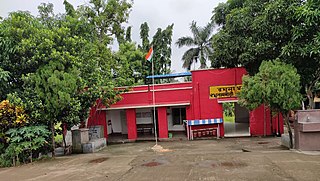
<span class="mw-page-title-main">Raghunathbari railway station</span> Railway station in West Bengal, India

The Raghunathbari railway station in the Indian state of West Bengal, serves Raghunathbari, Kaminachak-Raghunathbari Road, India in Purba Medinipur district. It is on the Panskura–Haldia line. It is 74 km (46 mi) from Howrah station and 7 km (4 mi) from Panskura.

<span class="mw-page-title-main">Rajgoda railway station</span> Railway station in West Bengal, India

Rajgoda railway station in the Indian state of West Bengal, serves Near NH 41, Rajgoda, India in Purba Medinipur district. It is on the Panskura–Haldia line. It is 82 km (51 mi) from Howrah station and 15 km (9 mi) from Panskura.

<span class="mw-page-title-main">Sahid Matangini railway station</span> Railway station in West Bengal, India

The Sahid Matangini railway station in the Indian state of West Bengal, serves Tamluk-Panskura Road, Tamluk, India in Purba Medinipur district. It is on the Panskura–Haldia line. It is 88 km (55 mi) from Howrah Station and 21 km (13 mi) from Panskura.

<span class="mw-page-title-main">Tamluk Junction railway station</span> Railway station in West Bengal, India

The Tamluk Junction railway station in the Indian state of West Bengal, serves Tamluk, India in Purba Medinipur district. It is on the Panskura–Haldia line. It is under the jurisdiction of South Eastern Railway zone. Tamluk Junction railway station is one of the busiest railway stations of Kharagpur railway division. It is 91 km (57 mi) from Howrah station and 24 km (15 mi) from Panskura.

Garh Kamalpur is a census town in Mahishadal CD block in Haldia subdivision of Purba Medinipur district in the state of West Bengal, India.

Barda is a census town in Sutahata CD block in Haldia subdivision of Purba Medinipur district in the state of West Bengal, India.

Bandar railway station is a railway station on the Panskura–Haldia branch line in South Eastern Railway zone of Indian Railways. The railway station is situated at Ranichak More, Haldia in Purba Medinipur district in the Indian state of West Bengal. Bandar railway station serves the Haldia Port areas.

Silpaprabesh railway station is a railway station on the Panskura–Haldia branch line in South Eastern Railway zone of Indian Railways. The railway station is situated at Haldia in Purba Medinipur district in the Indian state of West Bengal.

Durgachak Town railway station is a railway station on the Panskura–Haldia branch line in South Eastern Railway zone of Indian Railways. The railway station is situated at Durgachak in Purba Medinipur district in the Indian state of West Bengal.

Durgachak railway station is a railway station on the Panskura–Haldia branch line in South Eastern Railway zone of Indian Railways. The railway station is situated at Durgachak in Purba Medinipur district in the Indian state of West Bengal. This railway station serves Durgachak area.

Basulya Sutahata railway station is a railway station on the Panskura–Haldia branch line in South Eastern Railway zone of Indian Railways. The railway station is situated beside Haldia–Mecheda road at Durbbabere, Sutahata in Purba Medinipur district in the Indian state of West Bengal.

Barda railway station is a railway station on the Panskura–Haldia branch line in South Eastern Railway zone of Indian Railways. The railway station is situated beside Kukrahati Road, Chaitannyapur at Barda in Purba Medinipur district in the Indian state of West Bengal.

Mahishadal railway station is a railway station on the Panskura–Haldia branch line in South Eastern Railway zone of Indian Railways. The railway station is situated beside Haldia–Mecheda Road at Mahishadal in Purba Medinipur district in the Indian state of West Bengal. This railway station serves Mahishadal area.

Satish Samanta Halt railway station is a halt railway station on the Panskura–Haldia branch line in South Eastern Railway zone of Indian Railways. The railway station is situated beside Mahishadal-Geonkhali Road, Rangibasan at Mahishadal in Purba Medinipur district in the Indian state of West Bengal. This railway station is named after Bengali freedom fighter Satish Chandra Samanta.

References

  1. http://wikimapia.org/1290168/hi/Durga-Chak-Town-Railway-Station Map of Durgachak (Wikimapia)
  2. "District Statistical Handbook 2014 Purba Medinipur". Tables 2.1, 2.2. Department of Statistics and Programme Implementation, Government of West Bengal. Archived from the original on 29 July 2017. Retrieved 10 November 2016.{{cite web}}: CS1 maint: unfit URL (link)
  3. "Durgachak PS". Purba Medinipur District Police. Retrieved 10 November 2016.
  4. "District Statistical Handbook 2014 Purba Medinipur". Table 2.2. Department of Planning and Statistics, Government of West Bengal. Retrieved 21 April 2019.
  5. Google Maps
  6. Kharagpur-Howrah Local 38606 Indiarailinfo
  7. Howrah-Haldia Local 68689 ⇒ 38089 Indiarailinfo
  8. Santragachi-Digha EMU 78001 ⇒ 68687 Indiarailinfo
  9. "38089 Howrah-Haldia Local". Time Table. indiarailinfo. Retrieved 10 November 2016.