Tamluk subdivision is a subdivision of the Purba Medinipur district in the state of West Bengal, India. It under Burdwan division.
Haldia subdivision is a subdivision of the Purba Medinipur district in the state of West Bengal, India.
Mahishadal is a community development block that forms an administrative division in Haldia subdivision of Purba Medinipur district in the Indian state of West Bengal.
Nandakumar is a community development block that forms an administrative division in Tamluk subdivision of Purba Medinipur district in the Indian state of West Bengal.
Tamluk is a community development block that forms an administrative division in Tamluk subdivision of Purba Medinipur district in the Indian state of West Bengal.
Chandipur is a village, in Chandipur CD block in Tamluk subdivision of Purba Medinipur district in the state of West Bengal, India.
Maharaja Nandakumar Mahavidyalaya, established in 2007 is a government aided degree college in Nandakumar, Purba Medinipore, West Bengal, India. With more than 14 subjects of study, it offers a vibrant and engaging environment to learn and grow through education and various other activities. It is affiliated to Vidyasagar University, Midnapore, West Bengal, India.
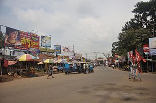
Nandakumar is a village in Nandakumar CD block in Tamluk subdivision of Purba Medinipur district in the state of West Bengal, India.
Palpara is a village, in Patashpur I CD Block in Egra subdivision of Purba Medinipur district in the state of West Bengal, India.
Bhupatinagar is a village, in Bhagabanpur II CD block in Contai subdivision of Purba Medinipur district in the state of West Bengal, India.
Durmut is a village, in Contai 3 CD Block in Contai subdivision of Purba Medinipur district in the state of West Bengal, India.
Kismat Bajkul is a village, in Bhagabanpur I CD block in Egra subdivision of Purba Medinipur district in the state of West Bengal, India.
Tethi Bari is a village, in Bhagabanpur I CD Block in Egra subdivision of Purba Medinipur district in the state of West Bengal, India.
Chaitanyapur is a village and a gram panchayat, in Sutahata CD block in Haldia subdivision of Purba Medinipur district in the state of West Bengal, India.
Janu Basan is a village in Sahid Matangini CD block in Tamluk subdivision of Purba Medinipur district in the state of West Bengal, India.
Garh Kamalpur is a census town in Mahishadal CD block in Haldia subdivision of Purba Medinipur district in the state of West Bengal, India.
Kotbar is a census town in Chandipur CD block in Tamluk subdivision of Purba Medinipur district in the state of West Bengal, India.
Barda is a census town in Sutahata CD block in Haldia subdivision of Purba Medinipur district in the state of West Bengal, India.
Shyamsundarpur Patna is a village in Panskura CD block in Tamluk subdivision of Purba Medinipur district in the state of West Bengal, India.
Jukhia is a village and a gram panchayat in the Bhagabanpur II CD block in the Contai subdivision of the Purba Medinipur district in the state of West Bengal, India.


