Kharagpurpronunciation (help·info) is an industrial city in Paschim Medinipur district of West Bengal, India. It is the headquarters of the Kharagpur subdivision. It is the most populated, multicultural and cosmopolitan city of the district. The first Indian Institute of Technology, one of the Institutes of National Importance, was founded in Kharagpur in May 1950. It has one of the largest railway workshops in India, and the fourth longest railway platform in the world.

Argari is a census town in Sankrail CD Block of Howrah Sadar subdivision in Howrah district in the Indian state of West Bengal. It is a part of Kolkata Urban Agglomeration.
Bagnan is a census town in Bagnan I CD Block of Uluberia subdivision in Howrah district in the state of West Bengal, India.
Dhuilya is a census town in Sankrail CD Block of Howrah Sadar subdivision in Howrah district in the Indian state of West Bengal. It is a part of Kolkata Urban Agglomeration.
Hatgachha is a census town in Sankrail CD Block of Howrah Sadar subdivision in Howrah district in the Indian state of West Bengal. It is a part of Kolkata Urban Agglomeration.
Mahiari is a census town in Domjur CD Block of Howrah Sadar subdivision in Howrah district in the Indian state of West Bengal. It is a part of Kolkata Urban Agglomeration.
Makardah is a census town in Domjur CD Block of Howrah Sadar subdivision in Howrah district in the Indian state of West Bengal. It is a part of Kolkata Urban Agglomeration.
Mansinghapur is a census town in Jagatballavpur CD Block of Howrah Sadar subdivision in Howrah district in the Indian state of West Bengal. It is close to Bargachia.
Naupala is a census town in Bagnan II CD Block of Uluberia subdivision in Howrah district in the Indian state of West Bengal.
Panchpara is a census town in Sankrail CD Block of Howrah Sadar subdivision in Howrah district in the Indian state of West Bengal. It is a part of Kolkata Urban Agglomeration.
Ramchandrapur is a census town in Sankrail CD Block of Howrah Sadar subdivision in Howrah district in the Indian state of West Bengal. It is a part of Kolkata Urban Agglomeration.

Sankrail is a census town in Sankrail CD Block of Howrah Sadar subdivision in Howrah district in the Indian state of West Bengal. It is a part of Kolkata Urban Agglomeration.
Amta I is a city and community development block that forms an administrative division in Uluberia subdivision of Howrah district in the Indian state of West Bengal.
Jagatballavpur is a community development block that forms an administrative division in Howrah Sadar subdivision of Howrah district in the Indian state of West Bengal.
Bagnan I is a community development block that forms an administrative division in Uluberia subdivision of Howrah district in the Indian state of West Bengal.
Kolaghat is a community development block that forms an administrative division in Tamluk subdivision of Purba Medinipur district in the Indian state of West Bengal.
Bagnan II is a community development block that forms an administrative division in Uluberia subdivision of Howrah district in the Indian state of West Bengal.
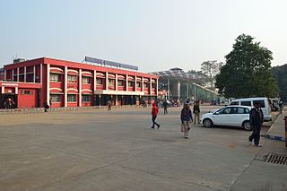
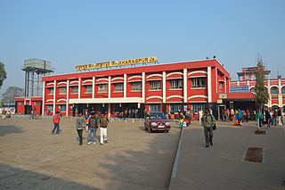
Kharagpur Junction railway station is a railway station in Kharagpur of Paschim Medinipur district in the Indian state of West Bengal. It is also the fourth longest railway station by platform length after Hubli Junction railway station, Gorakhpur Junction railway station and Kollam Junction railway station. It is an A-1 category station of Indian Railways.

Kulgachia is a village of Howrah district in the state West Bengal, India. The rail station located at the center of the town is only 40 km from howrah station and NH6 is only about 500 meter from the station area. Over the last five years it has been changed, developed and grown drastically to a town from village life though it is under panchayet raj administrative system yet. Populations are dramatically increased here nowadays due to the good communication with Kolkata, Kharagpur and other economically important parts of the state West Bengal.
The Bagnan railway station in the Indian state of West Bengal, serves Bagnan, India in Howrah district. It is on the Howrah–Kharagpur line. It is 45 km (28 mi) from Howrah Station. A line to Gadiara has been proposed.