Balaram Pota

Last updated

Balaram Pota
Census Town
West Bengal location map.svg
Red pog.svg
Balaram Pota
Location in West Bengal, India
India location map 3.png
Red pog.svg
Balaram Pota
Balaram Pota (India)
Coordinates: 22°30′41″N88°08′50″E / 22.51147°N 88.14724°E / 22.51147; 88.14724 Coordinates: 22°30′41″N88°08′50″E / 22.51147°N 88.14724°E / 22.51147; 88.14724
CountryFlag of India.svg  India
State West Bengal
District Howrah
Population
 (2011)
  Total5,544
Languages
  Official Bengali, English
Time zone UTC+5:30 (IST)
Vehicle registration WB
Lok Sabha constituency Uluberia
Vidhan Sabha constituency Uluberia Uttar
Website howrah.gov.in

Balaram Pota is a census town in Uluberia II CD Block of Uluberia subdivision in Howrah district in the Indian state of West Bengal. It is a part of Kolkata Urban Agglomeration. [1]

Contents

Geography

Balaram Pota is located at 22°30′41″N88°08′50″E / 22.51147°N 88.14724°E / 22.51147; 88.14724

Demographics

As per 2011 Census of India Balaram Pota had a total population of 5,544 of which 2,853 (51%) were males and 2,691 (49%) were females. Population below 6 years was 718. The total number of literates in Balaram Pota was 4,354 (90.22% of the population over 6 years). [2]

Balaram Pota was part of Kolkata Urban Agglomeration in 2011 census. [3]

As of 2001 India census, [4] Balaram Pota had a population of 4,488. Males constitute 52% of the population and females 48%. Balaram Pota has an average literacy rate of 71%, higher than the national average of 59.5%; with 56% of the males and 44% of females literate. 14% of the population is under 6 years of age.

Related Research Articles

Nalpur Census Town in West Bengal, India

Nalpur is a census town in Sankrail CD Block of Howrah Sadar subdivision in Howrah district in the Indian state of West Bengal. It is a part of Kolkata Urban Agglomeration.

Amodghata Census Town in West Bengal, India

Amodghata is a census town in Chinsurah Mogra CD Block in Chinsurah subdivision of Hooghly district in the state of West Bengal, India. It is a part of Kolkata Urban Agglomeration.

Ankurhati Census Town in West Bengal, India

Ankurhati is a census town in Domjur CD Block of Howrah Sadar subdivision in Howrah district in the Indian state of West Bengal. It is a part of Kolkata Urban Agglomeration.

Argari Census Town in West Bengal, India

Argari is a census town in Sankrail CD Block of Howrah Sadar subdivision in Howrah district in the Indian state of West Bengal. It is a part of Kolkata Urban Agglomeration.

Bamunari Census Town in West Bengal, India

Bamunari is a census town of Sreerampur Uttarpara CD Block in Srirampore subdivision of Hooghly district in the state of West Bengal, India. It is a part of Kolkata Urban Agglomeration.

Dakshin Jhapardaha Census Town in West Bengal, India

Dakshin Jhapardaha is a census town in Domjur CD Block of Howrah Sadar subdivision in Howrah district in the state of West Bengal, India. It is close to Domjur and also a part of Kolkata Urban Agglomeration.

Hatgachha Census Town in West Bengal, India

Hatgachha is a census town in Sankrail CD Block of Howrah Sadar subdivision in Howrah district in the Indian state of West Bengal. It is a part of Kolkata Urban Agglomeration.

Jhorhat Census Town in West Bengal, India

Jhorhat is a census town in Sankrail CD Block of Howrah Sadar subdivision in Howrah district in the Indian state of West Bengal. It is a part of Kolkata Urban Agglomeration.

Kantlia Census Town in West Bengal, India

Kantlia is a census town in Domjur CD Block of Howrah Sadar subdivision in Howrah district in the Indian state of West Bengal. It is a part of Kolkata Urban Agglomeration.

Khantora Census Town in West Bengal, India

Khantora is a census town in Domjur CD Block of Howrah Sadar subdivision in Howrah district in the Indian state of West Bengal. It is a part of Kolkata Urban Agglomeration.

Manikpur, West Bengal Census Town in West Bengal, India

Manikpur is a census town in Sankrail CD Block of Howrah Sadar subdivision in Howrah district in the Indian state of West Bengal. It is a part of Kolkata Urban Agglomeration.

Panchpara Census Town in West Bengal, India

Panchpara is a census town in Sankrail CD Block of Howrah Sadar subdivision in Howrah district in the Indian state of West Bengal. It is a part of Kolkata Urban Agglomeration.

Raghudebbati Census Town in West Bengal, India

Raghudebbati is a census town in Sankrail CD Block of Howrah Sadar subdivision in Howrah district in the Indian state of West Bengal. It is a part of Kolkata Urban Agglomeration.

Tentulkuli Census Town in West Bengal, India

Tentulkuli is a census town in Domjur CD Block of Howrah Sadar subdivision in Howrah district in the Indian state of West Bengal. It is close to Salap and also a part of Kolkata Urban Agglomeration.

Uttar Pirpur Census Town in West Bengal, India

Uttar Pirpur is a census town in Uluberia II CD Block of Uluberia subdivision in Howrah district in the Indian state of West Bengal. It is a part of Kolkata Urban Agglomeration.

Santoshpur, Uluberia Census Town in West Bengal, India

Santoshpur is a census town in Uluberia II CD Block of Uluberia subdivision in Howrah district in the Indian state of West Bengal. It is a part of Kolkata Urban Agglomeration.

Bally Jagachha Community development block in West Bengal, India

Bally Jagachha is a community development block that forms an administrative division in Howrah Sadar subdivision of Howrah district in the Indian state of West Bengal.

Domjur (community development block) Community development block in West Bengal, India

Domjur is a community development block that forms an administrative division in Howrah Sadar subdivision of Howrah district in the Indian state of West Bengal.

Sankrail (community development block) Community development block in West Bengal, India

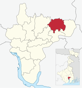
Sankrail is a community development block that forms an administrative division in Howrah Sadar subdivision of Howrah district in the Indian state of West Bengal.

Uluberia II Community development block in West Bengal, India

Uluberia II is a community development block that forms an administrative division in Uluberia subdivision of Howrah district in the Indian state of West Bengal.

References

  1. "District-wise list of stautory towns". Census Commission of India. Archived from the original on 30 September 2007. Retrieved 28 January 2009.
  2. "C.D. Block Wise Primary Census Abstract Data(PCA)". 2011 census: West Bengal – District-wise CD Blocks. Registrar General and Census Commissioner, India. Retrieved 11 May 2016.
  3. "Provisional Population Totals, Census of India 2011" (PDF). Constituents of Urban Agglomeration Having Population Above 1 Lakh. Census of India 2011. Retrieved 11 May 2016.
  4. "Census of India 2001: Data from the 2001 Census, including cities, villages and towns (Provisional)". Census Commission of India. Archived from the original on 16 June 2004. Retrieved 1 November 2008.