
Howrah is a district in the Indian state of West Bengal. Howrah city is located on the western bank of the Hooghly River. Administratively Howrah city lies within Howrah district, and is the headquarters of the Howrah Sadar subdivision. It is also part of the Kolkata Metropolitan Area, with development from the Kolkata Metropolitan Development Authority. Howrah city is an important transportation hub and suburb of Kolkata. It is also a gateway to old Kolkata via Howrah railway station and Howrah Bridge.

Kharagpur is a semi-planned urban agglomeration and a major industrial city in the Paschim Medinipur district of West Bengal, India. It is the headquarters of the Kharagpur subdivision and the largest city of the district. It is located 120 km west of Kolkata. Kharagpur holds the oldest and biggest Indian Institute of Technology namely IIT Kharagpur. It has one of the largest railway workshops in India. Kharagpur Junction contains the fourth longest railway platform in the world and is the headquarter of the Kharagpur Division of the South Eastern Railways.

Howrah railway station is a railway station located in the city of Howrah, West Bengal, India. It is the largest and busiest railway complex in India as well as one of the busiest and largest train stations in the world. It is also the oldest surviving railway station complex in India. Howrah is one of six intercity train stations serving the Kolkata metropolitan area, the others being Sealdah, Dankuni, Santragachi, Shalimar and Kolkata railway station.

Haldia is an industrial port city in Purba Medinipur district in the Indian state of West Bengal. It has a major river port and industrial belt located approximately 124 km (77 mi) southwest of Kolkata near the mouth of the Hooghly River, one of the distributaries of the Ganges. The Haldia Township is bordered by the Haldi River, an offshoot of the Ganges River. Haldia is a centre for petrochemical businesses, and is a major trade port for Kolkata.

Kolaghat is a census town in Kolaghat CD Block, Tamluk subdivision of the Purba Medinipur district in the state of West Bengal, India.

Bankura is a city and a municipality in the state of West Bengal, India. It is the headquarters of the Bankura district.Bankura was described as Suhmobhumi. The word larh or rarh was introduced after 6th century A.D. It comes from the old Austric word ráŕhá or ráŕho which means “land of red soil”. 2-n ancient times "China called Ráŕh by the name of 'Láti'". 3-n Santali, lar means thread, rarh means tune and larh means snake. 4-.Perhaps the Jain and Greek scholars used this original Austric word larh to indicate this dry forest region which was very difficult. The popularity of Manasa Puja, the worship of Snake-Goddess Manasa, shows this opinion might have some relevance. According to Nilkantha, a commentator of the Mahabharata, the words suhmo [bhumi] and Rarh are synonymous.
Jagacha or Jagachha is a neighborhood in Howrah, located in Howrah district of West Bengal, India. It is a part of the area covered by Kolkata Metropolitan Development Authority (KMDA).

Malbazar, also known as Mal, is a town and a municipality in Jalpaiguri district in the state of West Bengal, India. It is the headquarters of the Malbazar subdivision. It lies about 65 km from Jalpaiguri and 55 km from Siliguri. It lies on the bank of river Neora.

Digha is a seaside resort town in the state of West Bengal, India. It lies in Purba Medinipur district and at the northern end of the Bay of Bengal. It has a low gradient with a shallow sand beach. It is a popular sea resort in West Bengal.

Andul is a census town in Sankrail CD Block of Howrah Sadar subdivision in Howrah district in the Indian state of West Bengal. It is a part of Kolkata Urban Agglomeration.

Bagnan is a census town in Bagnan I CD Block of Uluberia subdivision in Howrah district in the state of West Bengal, India.
Dainhat is a town and a Municipality under Katwa police station of Katwa subdivision, in Purba Bardhaman district in the state of West Bengal, India.

Ganjam is a town and a notified area council in Ganjam district in the state of Odisha, India. Brahmapur, one of the major city of Odisha is situated in this district.

Raiganj Wildlife Sanctuary is situated near Raiganj in Uttar Dinajpur district in the Indian state of West Bengal. The bird sanctuary is home to 164 species of birds, and some 90,000 to 100,000 migratory birds visit the sanctuary every year. As per the MEE report, West Bengal''s Jaldapara national park and Raiganj wildlife sanctuary, Himachal Pradesh''s Sainj and Tirthan wildlife sanctuaries as well as the Great Himalayan national park have been declared as top five national parks and wildlife sanctuaries in India.
Benapur is a village in Bagnan-II Block, Howrah District, West Bengal. Its location, beside the Rupnarayana River, has made it to an wonderful place for picnic. Its Geographic location is 22.47°N 87.97°E.
Geonkhali is a village and scenic tourist spot in the Mahishadal Block of East Midnapore district of West Bengal.
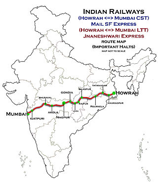
The Howrah–Nagpur–Mumbai line is a railway line in India connecting Kolkata and Mumbai via Nagpur. The 1,968-kilometre-long (1,223 mi) railway line was opened to traffic in 1900.

The Howrah–Kharagpur line is part of the Howrah–Nagpur–Mumbai line, Howrah–Chennai main line and Kolkata Suburban Railway.
Tiljala is a neighbourhood of South Kolkata, in West Bengal, India.

Bhadrak railway station is a passenger railway station serves Bhadrak district in Indian state of Odisha. It is situated on the howrah chennai main railline. It comes under (NSG3) railway stations category of India.


