Muragachha

Last updated

Muragachha
Census Town
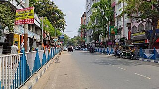
Sodepur-Barasat Road - Kalyani Expressway Junction - Kolkata 2017-03-30 0894.JPG
Sodepur-Barasat Road and Kalyani Expressway Junction, Muragachha
West Bengal location map.svg
Red pog.svg
Muragachha
Location in West Bengal, India
India location map 3.png
Red pog.svg
Muragachha
Muragachha (India)
Coordinates: 22°41′46″N88°25′12″E / 22.696°N 88.420°E / 22.696; 88.420 Coordinates: 22°41′46″N88°25′12″E / 22.696°N 88.420°E / 22.696; 88.420
CountryFlag of India.svg  India
State West Bengal
District North 24 Parganas
Area
  Total1.21 km2 (0.47 sq mi)
Elevation
11 m (36 ft)
Population
 (2011)
  Total13,249
  Density11,000/km2 (28,000/sq mi)
Languages
  Official Bengali, English
Time zone UTC+5:30 (IST)
PIN
700110
Telephone code+91 33
ISO 3166 code IN-WB
Vehicle registration WB
Lok Sabha constituency Dum Dum
Vidhan Sabha constituency Khardaha
Website north24parganas.nic.in

Muragachha is a census town in Barrackpore II CD Block in Barrackpore subdivision [1] in North 24 Parganas district in the Indian state of West Bengal. It is close to Kolkata and also a part of Kolkata Urban Agglomeration.

Contents

Geography

Cities and towns in the southern portion of Barrackpore subdivision in North 24 Parganas district
M: municipal city/ town, CT: census town,
N: neighbourhood/ administrative location
Owing to space constraints in the small map, the actual locations in a larger map may vary slightly

Location

Muragachha is located at 22°41′N88°25′E / 22.69°N 88.42°E / 22.69; 88.42 . [2] It has an average elevation of 11 m (36 ft).

Muragachha, Talbandha, Chandpur and Teghari form a cluster of census towns around/ near the Sodepur-Barasat Road, between Panihati and New Barrackpur. [3]

96% of the population of Barrackpore subdivision (partly presented in the map alongside, all places marked in the map are linked in the full screen map) lives in urban areas. In 2011, it had a density of population of 10,967 per km2. The subdivision has 16 municipalities and 24 census towns. [4]

For most of the cities/ towns information regarding density of population is available in the Infobox. Population data is not available for neighbourhoods. It is available for the entire municipal area and thereafter ward-wise.

Police station

Khardaha police station under Barrackpore Police Commissionerate has jurisdiction over Khardaha municipal area and Barrackpore II CD Block. [5] [6]

Demographics

Population

As per 2011 Census of India Muragachha had a total population of 13,249, of which 6,758 (51%) were males and 6,491 (49%) were females. Population below 6 years was 1,242. The total number of literates in Muragachha was 10,063 (83.81% of the population over 6 years). [7]

As of 2001 India census, [8] Muragachha had a population of 9790. Males constitute 51% of the population and females 49%. Muragachha has an average literacy rate of 74%, higher than the national average of 59.5%: male literacy is 79% and female literacy is 68%. In Muragachha, 12% of the population is under 6 years of age.

Kolkata Urban Agglomeration

The following Municipalities, Census Towns and other locations in Barrackpore subdivision were part of Kolkata Urban Agglomeration in the 2011 census: Kanchrapara (M), Jetia (CT), Halisahar (M), Balibhara (CT), Naihati (M), Bhatpara (M), Kaugachhi (CT), Garshyamnagar (CT), Garulia (M), Ichhapur Defence Estate (CT), North Barrackpur (M), Barrackpur Cantonment (CB), Barrackpore (M), Jafarpur (CT), Ruiya (CT), Titagarh (M), Khardaha (M), Bandipur (CT), Panihati (M), Muragachha (CT) New Barrackpore (M), Chandpur (CT), Talbandha (CT), Patulia (CT), Kamarhati (M), Baranagar (M), South Dumdum (M), North Dumdum (M), Dum Dum (M), Noapara (CT), Babanpur (CT), Teghari (CT), Nanna (OG), Chakla (OG), Srotribati (OG) and Panpur (OG). [9]

Infrastructure

As per the District Census Handbook 2011, Muragachha covered an area of 1.21 km2. Amongst the medical facilities it had were 3 medicine shops. Amongst the educational facilities it had were 2 primary schools, 1 middle school, 1 secondary school and 1 senior secondary school. [10]

Transport

Muragachha is the junction of Kalyani Expressway and Sodepur-Barasat road. [11]

Bus

Private Bus

WBTC Bus

Bus Route Without Number

Train

The nearest railway stations are Madhyamgram railway station on the Sealdah-Bangaon line and Sodepur railway station on the Sealdah-Ranaghat line. [12] [11] [13]

Healthcare

Bilkanda (Teghoria ) primary health centre at Muragachha has 6 beds. [14]

North 24 Parganas district has been identified as one of the areas where ground water is affected by arsenic contamination. [15]

Related Research Articles

Khardaha Neighbourhood in Kolkata in North 24 Parganas, West Bengal, India

Khardaha is a city and a municipality of North 24 Parganas district in the Indian state of West Bengal. It is near Kolkata and also a part of the area covered by Kolkata Metropolitan Development Authority (KMDA).

Sodepur Neighbourhood in Kolkata in Greater Kolkata, West Bengal, India

Sodepur or Sodpur is a neighbourhood in the North 24 Parganas district of the India state of West Bengal. It is close to Kolkata and also a part of the area covered by Kolkata Metropolitan Development Authority (KMDA). The pin code of this locality is 700110.

Jagatdal Neighbourhood in North 24 Parganas, West Bengal, India

Jagaddal is a city in Bhatpara Municipality of North 24 Parganas district in the Indian state of West Bengal. It is a part of the area covered by Kolkata Metropolitan Development Authority (KMDA). It is also a manufacturing hub of jute industry, there are 7 big jute mills in this city. Prime Ministers Narendra Modi Visited the City During His Election Campaign.

Barrackpur Cantonment City in West Bengal, India

Barrackpur Cantonment is a city and a cantonment board of North 24 Parganas district in the Indian state of West Bengal. It is close to Kolkata and also a part of the area covered by Kolkata Metropolitan Development Authority (KMDA).

Garshyamnagar Census Town in West Bengal, India

Garshyamnagar is a census town in Barrackpore I CD Block in Barrackpore subdivision in North 24 Parganas district in the state of West Bengal, India. It is a part of Kolkata Urban Agglomeration.

Jafarpur Census Town in West Bengal, India

Jafarpur is a census town in Barrackpore II CD Block in Barrackpore subdivision in North 24 Parganas district in the Indian state of West Bengal. It is close to Kolkata and also part of Kolkata Urban Agglomeration.

Jetia Census Town in West Bengal, India

Jetia is a census town in Barrackpore I CD Block in Barrackpore subdivision in North 24 Parganas district in the Indian state of West Bengal. It is a part of Kolkata Urban Agglomeration.

Kaugachhi Census Town in West Bengal, India

Kaugachhi is a census town in Barrackpore I CD Block in Barrackpore subdivision in North 24 Parganas district in the Indian state of West Bengal. It is a part of Kolkata Urban Agglomeration.

Ruiya Census Town in West Bengal, India

Ruiya is a census town in Barrackpore II CD Block in Barrackpore subdivision in North 24 Parganas district in the Indian state of West Bengal. It is close to Kolkata and also a part of Kolkata Urban Agglomeration.

Talbandha Census Town in West Bengal, India

Talbandha is a census town in Barrackpore II CD Block in Barrackpore subdivision in North 24 Parganas district in the Indian state of West Bengal. It is close to Kolkata and also a part of Kolkata Urban Agglomeration.

Belgharia Neighbourhood in Kolkata in West Bengal, India

Belgharia or Belghoria is a locality in the Indian state of West Bengal. It is close to Kolkata and also a part of the area covered by Kolkata Metropolitan Development Authority (KMDA). Belgharia is also known for wholesale market for all types of Bags/Luggages/Purse etc. One must visit and check the Bag Market beside Belgharia Railway Station. The great Dakshineswar Kali Temple of Kolkata is in approximately three kilometers distance from Belgharia Railway Station. The Vivekananda Setu on the river of Hooghly which is one of the oldest bridge in Calcutta established for the connection between the city of Howrah and Kolkata is also at the adjacent area of Belgharia.

Chandpur, Ghola Census Town in West Bengal, India

Chandpur is a census town in Barrackpore II CD Block in Barrackpore subdivision in North 24 Parganas district in the state of West Bengal, India. It is close to Kolkata and also a part of Kolkata Urban Agglomeration.

Noapara, North 24 Parganas Census Town in West Bengal, India

Noapara is a census town in Barrackpore I CD Block in Barrackpore subdivision of North 24 Parganas district in the Indian state of West Bengal. It is a part of Kolkata Urban Agglomeration.

Ghola, North 24 Parganas Neighbourhood in North 24 Parganas, West Bengal, India

Ghola is a locality in Panihati Municipality of North 24 Parganas district in the Indian state of West Bengal. It is close to Kolkata and also a part of the area covered by Kolkata Metropolitan Development Authority (KMDA).
Agarpara Neighbourhood in Kolkata in North 24 Parganas, West Bengal, India

Agarpara is a locality in Panihati Municipality of North 24 Parganas district in the Indian state of West Bengal. It is close to Kolkata and also a part of the area covered by Kolkata Metropolitan Development Authority (KMDA).

Sukchar Neighbourhood in North 24 Parganas, West Bengal, India

Sukchar is a locality in Panihati Municipality of North 24 Parganas district in the Indian state of West Bengal. It is close to Kolkata and also a part of the area covered by Kolkata Metropolitan Development Authority (KMDA).

Balibhara Census Town in West Bengal, India

Balibhara is a census town in Barrackpore I CD Block of Barrackpore subdivision in North 24 Parganas district in the Indian state of West Bengal. It is a part of Kolkata Urban Agglomeration.

Bilkanda Census Town in West Bengal, India

Bilkanda is a census town in Barrackpore II CD Block in Barrackpore subdivision of North 24 Parganas district in the state of West Bengal, India. It is close to Kolkata and also a part of Kolkata Urban Agglomeration.

Teghari Census Town in West Bengal, India

Teghari is a census town in Barrackpore II CD Block in Barrackpore subdivision of North 24 Parganas district in the state of West Bengal, India. It is close to Kolkata and also a part of Kolkata Urban Agglomeration.

Babanpur Census Town in West Bengal, India

Babanpur is a census town in Barrackpore II CD Block in Barrackpore subdivision of North 24 Parganas district in the state of West Bengal, India. It is close to Kolkata and also a part of Kolkata Urban Agglomeration.

References

  1. District-wise list of statutory towns Archived 2007-08-09 at the Wayback Machine
  2. Falling Rain Genomics, Inc - Muragachha
  3. "District Census Handbook North Twenty Four Parganas, Census of India 2011, Series 20, Part XII A" (PDF). Map of Barrackpore II CD Block on Page 379. Directorate of Census Operations, West Bengal. Retrieved 15 June 2018.
  4. "District Statistical Handbook". North 24 Parganas 2013, Tables 2.1, 2.2, 2.4b. Department of Statistics and Programme Implementation, Government of West Bengal. Archived from the original on 21 January 2019. Retrieved 2 May 2018.
  5. "District Statistical Handbook". North 24 Parganas 2013, Table 2.1. Department of Statistics and Programme Implementation, Government of West Bengal. Archived from the original on 21 January 2019. Retrieved 15 June 2018.
  6. "Barrackpore Police Commissionerate". List of Police Stations with telephone numbers. West Bengal Police. Archived from the original on 12 June 2018. Retrieved 15 June 2018.
  7. "C.D. Block Wise Primary Census Abstract Data(PCA)". 2011 census: West Bengal – District-wise CD Blocks. Registrar General and Census Commissioner, India. Retrieved 23 March 2016.
  8. "Census of India 2001: Data from the 2001 Census, including cities, villages and towns (Provisional)". Census Commission of India. Archived from the original on 16 June 2004. Retrieved 1 November 2008.
  9. "Provisional Population Totals, Census of India 2011" (PDF). Constituents of Urban Agglomeration Having Population Above 1 Lakh. Census of India 2011. Retrieved 7 June 2018.
  10. "District Census Handbook North Twenty Four Parganas, Census of India 2011, Series 20, Part XII A" (PDF). Section II Town Directory, Pages 781-783 Statement I: Growth History, Pages 799-803; Statement II: Physical Aspects and Location of Towns, Pages 791-794; Statement III: Civic and other Amenities, Pages 795-796; Statement IV: Medical Facilities 2009, Pages 803-805 Section: Educational, Recreational and Cultural Facilities. Directorate of Census Operations V, West Bengal. Retrieved 19 June 2018.
  11. 1 2 Google maps
  12. "31311 Sealdah-Kalyani Simanta Local". Time Table. indiarailinfo. Retrieved 15 June 2018.
  13. "33811 Sealdah-Bangaon local". Time Table. India Railinfo. Retrieved 15 June 2018.
  14. "Health & Family Welfare Department". Health Statistics. Government of West Bengal. Retrieved 24 June 2018.
  15. "Groundwater Arsenic contamination in West Bengal-India (19 years study )". Groundwater arsenic contamination status of North 24-Parganas district, one of the nine arsenic affected districts of West Bengal-India. SOES. Archived from the original on 27 September 2007. Retrieved 24 August 2007.