Karna Madhabpur

Last updated

Karna Madhabpur
Village
Karnamadhabpur Wetland - Kalyani Expressway - Panihati - Kolkata 2017-03-30 0900.JPG
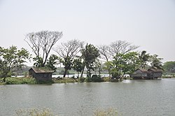
Karna Madhabpur Wetland
West Bengal location map.svg
Red pog.svg
Karna Madhabpur
Location in West Bengal, India
India location map.svg
Red pog.svg
Karna Madhabpur
Karna Madhabpur (India)
Coordinates: 22°43′31″N88°24′49″E / 22.7252°N 88.4135°E / 22.7252; 88.4135 Coordinates: 22°43′31″N88°24′49″E / 22.7252°N 88.4135°E / 22.7252; 88.4135
CountryFlag of India.svg  India
State West Bengal
District North 24 Parganas
Population
 (2011)
  Total3,088
Languages
  Official Bengali, English
Time zone UTC+5:30 (IST)
PIN
700113
Telephone/STD code033
Lok Sabha constituency Dum Dum
Vidhan Sabha constituency Khardaha
Website north24parganas.nic.in

Karna Madhabpur is a village in Barrackpore II CD Block in Barrackpore subdivision of North 24 Parganas district in the state of West Bengal, India. It is close to Kolkata and also a part of Kolkata Urban Agglomeration.

Contents

Geography

Cities and towns in the southern portion of Barrackpore subdivision in North 24 Parganas district
M: municipal city/ town, CT: census town,
N: neighbourhood/ administrative location
Owing to space constraints in the small map, the actual locations in a larger map may vary slightly

Location

Khardaha, Bandipur, Bilkanda and Nilganj are located nearby. [1]

96% of the population of Barrackpore subdivision (partly presented in the map alongside, all places marked in the map is linked in the full screen map) lives in urban areas. In 2011, it had a density of population of 10,967 per km2. The subdivision has 16 municipalities and 24 census towns. [2]

For most of the cities/ towns information regarding density of population is available in the Infobox. Population data is not available for neighbourhoods. It is available for the entire Municipal area and thereafter ward-wise.

Police station

Khardaha police station under Barrackpore Police Commissionerate has jurisdiction over Khardaha Municipal area and Barrackpore II CD Block. [3] [4]

CD Block HQ

The headquarters of Barrackpore II CD Block is at Karna Madhabpur. [5]

Demographics

As per the 2011 Census of India, Karna Madhabpur had a total population of 3,088, of which 1,592 (52%) were males and 1,496 (48%) were females. Population below 6 years was 321. The total number of literates in Karna Madhabpur was 2,313 (83.59% of the population over 6 years). [6]

Transport

Kalyani Expressway runs through Karna Madhabpur. [1]

Bus

Private Bus

WBTC Bus

Train

Both Sodepur railway station and Khardaha railway station on the Sealdah-Ranaghat line are located nearby. [7] [1]

Education

Elitte Institute of Engineering and Management was established at PO Karna Madhabpur in 2009. It offers diploma (3-years) courses in automobile, civil, electronics & telecommunication, electrical and mechanical engineering, computer science & technology, and hotel management & catering technology. [8]

Healthcare

Block Primary Health Centre at Bandipur is located nearby. [9] [1]

Related Research Articles

<span class="mw-page-title-main">Khardaha</span> City in West Bengal, India

Khardaha is a city and a municipality of North 24 Parganas district in the Indian state of West Bengal. It is near Kolkata and also a part of the area covered by Kolkata Metropolitan Development Authority (KMDA).

<span class="mw-page-title-main">Sodepur</span> Neighbourhood in Greater Kolkata, West Bengal, India

Sodepur or Sodpur is a locality in Panihati Municipality of North 24 Parganas district in the Indian state of West Bengal. It is close to Kolkata and also a part of the area covered by Kolkata Metropolitan Development Authority (KMDA). Barrackpore, Kamarhati, Dumdum, Agarpara, and Belghoria are all close by. It is a centre for rising residential construction. GM Meena Icon, Peerless Nagar, Merlin Maximus, Godrej Prakriti, and NPR Gitanjali Apartments are a few notable residential developments in the neighbourhood.

Jafarpur is a census town in Barrackpore II CD Block in Barrackpore subdivision in North 24 Parganas district in the Indian state of West Bengal. It is close to Kolkata and also part of Kolkata Urban Agglomeration.

Jetia is a census town in Barrackpore I CD Block in Barrackpore subdivision in North 24 Parganas district in the Indian state of West Bengal. It is a part of Kolkata Urban Agglomeration.

<span class="mw-page-title-main">Muragachha</span> Census Town in West Bengal, India

Muragachha is a census town in Barrackpore II CD Block in Barrackpore subdivision in North 24 Parganas district in the Indian state of West Bengal. It is close to Kolkata and also a part of Kolkata Urban Agglomeration.

Patulia is a census town in Barrackpore II CD Block in Barrackpore subdivision in North 24 Parganas district in the Indian state of West Bengal. It is close to Kolkata and also a part of Kolkata Urban Agglomeration.

Ruiya is a census town in Barrackpore II CD Block in Barrackpore subdivision in North 24 Parganas district in the Indian state of West Bengal. It is close to Kolkata and also a part of Kolkata Urban Agglomeration.

Talbandha is a census town in Barrackpore II CD Block in Barrackpore subdivision in North 24 Parganas district in the Indian state of West Bengal. It is close to Kolkata and also a part of Kolkata Urban Agglomeration.

Chandpur is a census town in Barrackpore II CD Block in Barrackpore subdivision in North 24 Parganas district in the state of West Bengal, India. It is close to Kolkata and also a part of Kolkata Urban Agglomeration.

Ghola is a locality in Panihati Municipality of North 24 Parganas district in the Indian state of West Bengal. It is close to Kolkata and also a part of the area covered by Kolkata Metropolitan Development Authority (KMDA).

Balibhara is a census town in Barrackpore I CD Block of Barrackpore subdivision in North 24 Parganas district in the Indian state of West Bengal. It is a part of Kolkata Urban Agglomeration.

Bandipur is a census town in Barrackpore II CD Block in Barrackpore subdivision of North 24 Parganas district in the state of West Bengal, India. It is close to Kolkata and also a part of Kolkata Urban Agglomeration.

Chak Kanthalia is a census town in Barrackpore II CD Block in Barrackpore subdivision of North 24 Parganas district in the state of West Bengal, India. It is close to Kolkata and also a part of Kolkata Urban Agglomeration.

Bilkanda is a census town in Barrackpore II CD Block in Barrackpore subdivision of North 24 Parganas district in the state of West Bengal, India. It is close to Kolkata and also a part of Kolkata Urban Agglomeration.

Teghari is a census town in Barrackpore II CD Block in Barrackpore subdivision of North 24 Parganas district in the state of West Bengal, India. It is close to Kolkata and also a part of Kolkata Urban Agglomeration.

Babanpur is a census town in Barrackpore II CD Block in Barrackpore subdivision of North 24 Parganas district in the state of West Bengal, India. It is close to Kolkata and also a part of Kolkata Urban Agglomeration.

<span class="mw-page-title-main">Mohanpur, North 24 Parganas</span> Census Town in West Bengal, India

Mohanpur is a census town in Barrackpore II CD Block in Barrackpore subdivision of North 24 Parganas district in the state of West Bengal, India. It is close to Kolkata and also a part of Kolkata Urban Agglomeration.

Telenipara is a census town in Barrackpore II CD Block in Barrackpore subdivision of North 24 Parganas district in the state of West Bengal, India. It is close to Kolkata and also a part of Kolkata Urban Agglomeration.

Panpur is an outgrowth of Bhatpara in Barrackpore I CD Block in Barrackpore subdivision of North 24 Parganas district in the state of West Bengal, India. Panpur-Keutia is a gram panchayat. It is a part of Kolkata Urban Agglomeration.

Nilganj is a village in Barrackpore II CD Block in Barrackpore subdivision of North 24 Parganas district in the state of West Bengal, India. It is close to Kolkata and also a part of Kolkata Urban Agglomeration.

References

  1. 1 2 3 4 Google maps
  2. "District Statistical Handbook". North 24 Parganas 2013, Tables 2.1, 2.2, 2.4b. Department of Statistics and Programme Implementation, Government of West Bengal. Retrieved 2 May 2018.
  3. "District Statistical Handbook". North 24 Parganas 2013, Table 2.1. Department of Statistics and Programme Implementation, Government of West Bengal. Retrieved 15 June 2018.
  4. "Barrackpore Police Commissionerate". List of Police Stations with telephone numbers. West Bengal Police. Archived from the original on 12 June 2018. Retrieved 15 June 2018.
  5. "District Census Handbook North Twenty Four Parganas, Census of India 2011, Series 20, Part XII A" (PDF). Map of North Twenty Four Parganas with CD Block HQs and Police Stations (on the fifth page). Directorate of Census Operations, West Bengal. Retrieved 15 June 2018.
  6. "C.D. Block Wise Primary Census Abstract Data(PCA)". West Bengal – District-wise CD Blocks. Registrar General and Census Commissioner, India. Retrieved 15 June 2018.
  7. "31311 Sealdah-Kalyani Simanta Local". Time Table. indiarailinfo. Retrieved 12 June 2018.
  8. "Elitte Institute of Engineering & Management". EIEM. Retrieved 15 June 2018.
  9. "Health & Family Welfare Department". Health Statistics. Government of West Bengal. Retrieved 15 June 2018.