Sandeshkhali

Last updated

Sandeshkhali
Village
West Bengal location map.svg
Red pog.svg
Sandeshkhali
Location in West Bengal, India
India location map.svg
Red pog.svg
Sandeshkhali
Sandeshkhali (India)
Coordinates: 22°21′59″N88°52′35″E / 22.366465°N 88.876436°E / 22.366465; 88.876436
CountryFlag of India.svg  India
State West Bengal
District North 24 Parganas
Languages
  Official Bengali,Hindi,English
Time zone UTC+5:30 (IST)
PIN
743446 (Sandeshkhali)
Telephone/STD code03218
Lok Sabha constituency Basirhat
Vidhan Sabha constituency Sandeshkhali
Website north24parganas.nic.in

Sandeshkhali is a village in the Sandeshkhali II CD block in the Basirhat subdivision of the North 24 Parganas district in the state of West Bengal, India.

Contents

Geography

Sandeshkhali
Cities, towns and locations in Basirhat subdivision, North 24 Parganas district
M: municipal town, CT: census town, R: rural/ urban centre
Owing to space constraints in the small map, the actual locations in a larger map may vary slightly

Location

Sandeshkhali is located at 22°21′59″N88°52′35″E / 22.366465°N 88.876436°E / 22.366465; 88.876436 .

Area overview

The area shown in the map is a part of the Ichhamati-Raimangal Plain, located in the lower Ganges Delta. It contains soil of mature black or brownish loam to recent alluvium. Numerous rivers, creeks and khals criss-cross the area. The tip of the Sundarbans National Park is visible in the lower part of the map (shown in green but not marked). The larger full screen map shows the full forest area. [1] A large section of the area is a part of the Sundarbans settlements. [2] The densely populated area is an overwhelmingly rural area. Only 12.96% of the population lives in the urban areas and 87.04% of the population lives in the rural areas. [3] [4]

Note: The map alongside presents some of the notable locations in the subdivision. All places marked in the map are linked in the larger full screen map.

Civic administration

Police station

Sandeshkhali police station serves a population of 328,989. It has jurisdiction over Sandeshkhali II CD block. There is an out-post at Rajbari. [5]

CD block HQ

The headquarters of Sandeshkhali II CD block are located at Dwarir Jangle. [6]

Demographics

In the map of Sandeshkhali II CD Block in the District Census Handbook, Sandeshkhali is shown as being part of Village No. 884 Dwarir Jangle. [7]

According to the 2011 Census of India, Dwarir Jangle had a total population of 11,155, of which 5,760 (52%) were males and 5,395 (48%) were females. Population in the age range 0–6 years was 1,321. The total number of literate persons in Dwarir Jangle was 6,857 (69.73% of the population over 6 years). [8]

Transport

The Kalindi flows past Sandeshkhali and there is a ferry service from Sandeshkhali ferry ghat to Bhangatushkhali ferry ghat. [9]

Sandeshkhali nearest railway station is Canning Railway Station (CG) distance from Sandeshkhali 34 km via Dhamakhali, Sorberia and Matla Bridge.

Education

Sandeshkhali Radharani High School is a co-educational higher secondary school. [10] Rajbari Agarhati Gourhari vidyapith is a co-educational higher secondary school.

Healthcare

Sandeshkhali Rural Hospital with 25 beds located at Sandeshkhali is the main medical facility in Sandeshkhali II CD Block. There are primary health centres at Korakanthi and Jeliakhli. [11]

Related Research Articles

<span class="mw-page-title-main">Basirhat</span> City in West Bengal, India

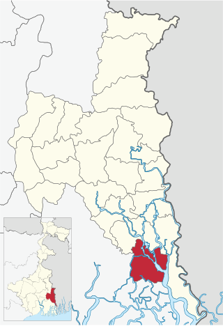
Basirhat is a city of West Bengal, India. It is located on the banks of the Ichamati (Ichhamati) River.

<span class="mw-page-title-main">Sandeshkhali I</span> Community development block in West Bengal, India

Sandeshkhali I is a community development block that forms an administrative division in Basirhat subdivision of North 24 Parganas district in the Indian state of West Bengal.

Haroa is a village in the Haroa CD block in the Basirhat subdivision of the North 24 Parganas district in the state of West Bengal, India.

Hasnabad is a village and a gram panchayat in the Hasnabad CD block in the Hasnabad subdivision of the North 24 Parganas district in the state of West Bengal, India.Hasnabad is called the' Second Gateway of Sunderban'.

<span class="mw-page-title-main">Sandeshkhali II</span> Community development block in West Bengal, India

Sandeshkhali-II is a community development block that forms an administrative division in Basirhat subdivision of North 24 Parganas district in the Indian state of West Bengal.

Dakshin Chatra is a census town in the Baduria CD block in the Basirhat subdivision in the North 24 Parganas district in the Indian state of West Bengal.

Swarupnagar is a village in the Swarupnagar CD block in the Basirhat subdivision of the North 24 Parganas district in the state of West Bengal, India. Swarupnagar Banglani forms a gram panchayat.

Minakhan is a census town in the Minakhan CD block in the Basirhat subdivision of the North 24 Parganas district in the state of West Bengal, India.

Hingalganj is a census town in the Hingalganj CD block in the Basirhat subdivision of the North 24 Parganas district in the state of West Bengal, India.

Nazat is a village and a gram panchayat in the Sandeshkhali I CD block in the Basirhat subdivision of the North 24 Parganas district in the state of West Bengal, India.

Matia is a village in the Basirhat II CD block in the Basirhat subdivision of the North 24 Parganas district in the state of West Bengal, India.

Iswarigachha is a village in the Baduria CD block in the Basirhat subdivision of the North 24 Parganas district in the state of West Bengal, India.

Mathurapur is a census town in the Basirhat II CD block in the Basirhat subdivision of the North 24 Parganas district in the state of West Bengal, India.

Sarapul is a village in the Swarupnagar CD block in the Basirhat subdivision of the North 24 Parganas district in the state of West Bengal, India.

Kalinagar is a village and a gram panchayat in the Sandeshkhali I CD block in the Basirhat subdivision of the North 24 Parganas district in the state of West Bengal, India.

Bamanpukuria is a village and a gram panchayat in the Minakhan CD block in the Basirhat subdivision of the North 24 Parganas district in the state of West Bengal, India.

Balihati is a census town in the Minakhan CD block in the Basirhat subdivision of the North 24 Parganas district in the state of West Bengal, India.

Sadigachhi is a census town in the Hasnabad CD block in the Basirhat subdivision of the North 24 Parganas district in the state of West Bengal, India.

Bankra is a census town in the Hingalganj CD block in the Basirhat subdivision of the North 24 Parganas district in the state of West Bengal, India.

Ghojadanga is a border checkpoint in the Basirhat II CD block in the Basirhat subdivision of the North 24 Parganas district in the state of West Bengal, India.

References

  1. "District Census Handbook North Twenty Four Parganas, Census of India 2011, Series 20, Part XII A" (PDF). Page 13. Directorate of Census Operations, West Bengal. Retrieved 16 April 2018.
  2. "District Human Development Report: South 24 Parganas". Chapter 9: Sundarbans and the Remote Islanders, p 290-311. Development & Planning Department, Government of West Bengal, 2009. Archived from the original on 5 October 2016. Retrieved 3 November 2019.
  3. "District Statistical Handbook". North 24 Parganas 2013, Tables 2.1, 2.2, 2.4b. Department of Statistics and Programme Implementation, Government of West Bengal. Archived from the original on 21 January 2019. Retrieved 2 May 2018.
  4. "District Census Handbook North Twenty Four Parganas, Census of India 2011, Series 20, Part XII A" (PDF). Map of North Twenty Four Parganas with CD Block HQs and Police Stations (on the fifth page). Directorate of Census Operations, West Bengal. Retrieved 2 May 2018.
  5. "North 24 Parganas Dist. Police". Know Your Police Station. District Police. Retrieved 6 May 2018.
  6. "District Census Handbook North Twenty Four Parganas, Census of India 2011, Series 20, Part XII A" (PDF). Map of North Twenty Four Parganas with CD Block HQs and Police Stations (on the fifth page). Directorate of Census Operations, West Bengal. Retrieved 12 May 2018.
  7. "District Census Handbook North Twenty Four Parganas, Census of India 2011, Series 20, Part XII A" (PDF). Page 657. Directorate of Census Operations, West Bengal. Retrieved 16 April 2018.
  8. "C.D. Block Wise Primary Census Abstract Data(PCA)". West Bengal – District-wise CD Blocks. Registrar General and Census Commissioner, India. Retrieved 11 May 2018.
  9. Google maps
  10. "Sandeshkhali Radharani High School". Target Study. Retrieved 19 May 2018.
  11. "Health & Family Welfare Department". Health Statistics. Government of West Bengal. Retrieved 11 May 2018.