Kharua Rajapur | |
|---|---|
Village | |
 | |
 Kharua Rajapur Location in West Bengal, India  Kharua Rajapur Kharua Rajapur (India) | |
| Coordinates: 22°59′41″N88°45′13″E / 22.99479°N 88.753568°E | |
| Country | India |
| State | West Bengal |
| Division | Presidency |
| District | North 24 Parganas |
| Government | |
| • Panchayet Pradhan | Hema Biswas (TMC) |
| Area | |
• Total | 2.33 km2 (0.90 sq mi) |
| Elevation | 9 m (30 ft) |
| Population (2011) | |
• Total | 1,591 |
| • Density | 683/km2 (1,770/sq mi) |
| Languages | |
| • Official | Bengali, English |
| Time zone | UTC+5.30 (IST) |
| PIN | 743251 |
| Telephone/STD code | 03215 |
| ISO 3166 code | IN-WB |
| Lok Sabha constituency | Bangaon |
| Vidhan Sabha constituency | Bangaon Uttar |
| Website | north24parganas |
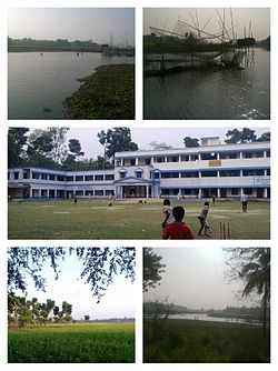
Kharua Rajapur is a village in Bangaon CD Block in Bangaon subdivision of North 24 Parganas district in the Indian state of West Bengal.


