Sodepur

Last updated

Sodepur
Sodpur
Neighbourhood
Amarabati Crossing - Sodepur 7456.JPG
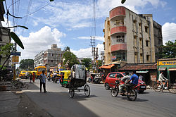
Amarabati crossing near Sodepur rail overbridge
West Bengal location map.svg
Red pog.svg
Sodepur
Location in West Bengal, India
India location map 3.png
Red pog.svg
Sodepur
Sodepur (India)
Coordinates: 22°41′54″N88°23′22″E / 22.698214°N 88.38947689999998°E / 22.698214; 88.38947689999998
CountryFlag of India.svg  India
State West Bengal
Region Greater Kolkata
District North 24 Parganas
Government
  Type Municipality
  Body Panihati Municipality
Elevation
15 m (49 ft)
Languages
  Official Bengali, English
Time zone UTC+5:30 (IST)
PIN
700110, 7000113, 700114, 700115,
Telephone code+91 33
Vehicle registration WB
Lok Sabha constituency Dum Dum
Vidhan Sabha constituency Panihati

Sodepur or Sodpur is a locality in Panihati Municipality of North 24 Parganas district in the Indian state of West Bengal. It is located in north suburban Kolkata and the area is covered by Kolkata Metropolitan Development Authority (KMDA). Barrackpore, Kamarhati, Dumdum, Agarpara, and Belghoria are all close by. It is a centre for rising residential construction. GM Meena Icon, Peerless Nagar, Merlin Maximus, Godrej Prakriti, and NPR Gitanjali Apartments are a few notable residential developments in the neighbourhood.

Contents

History

There was once a community named Sayyid in this area from which the place was known as Sayyidpur or Sodepur. [1] The Khadi Pratishthan (Ashram) of Sodepur (or Khadi Ashram Sodepur) has witnessed many events in the history of the country's independence movement. This Pratishthan was like Sabarmati near Sodepur station which Gandhiji himself called his 'second home'. The importance of this Khadi Pratishthan is immense as it has witnessed many histories in the making. Several important decisions were taken by the national leaders on this premises.

Geography

Sodepur
Cities and towns in the southern portion of Barrackpore subdivision in North 24 Parganas district
M: municipal city/ town, CT: census town,
N: neighbourhood/ administrative location
Owing to space constraints in the small map, the actual locations in a larger map may vary slightly

Location

Sodepur is located at 22°41′54″N88°23′22″E / 22.698214°N 88.38947689999998°E / 22.698214; 88.38947689999998 . [2] It has an average elevation of 15 m (49 ft).

96% of the population of Barrackpore subdivision (partly presented in the map alongside, all places marked on the map are linked in the full screen map) lives in urban areas. In 2011, it had a density of population of 10,967 per km2. The subdivision has 16 municipalities and 24 census towns. [3]

For most of the cities/ towns information regarding density of population is available in the Infobox. Population data is not available for neighbourhoods. It is available for the entire municipal area and thereafter ward-wise.

Police station

Ghola and Khardaha police station under Barrackpore Police Commissionerate has jurisdiction over Panihati and New Barrackpore Municipal areas. [4] [5]

There is a police outpost at Sodepur. Main police station - Khardah Police Station. [ citation needed ]

Kolkata Urban Agglomeration

The following Municipalities, Census Towns and other locations in Barrackpore subdivision were part of Kolkata Urban Agglomeration in the 2011 census: Kanchrapara (M), Jetia (CT), Halisahar (M), Balibhara (CT), Naihati (M), Bhatpara (M), Kaugachhi (CT), Garshyamnagar (CT), Garulia (M), Ichhapur Defence Estate (CT), North Barrackpur (M), Barrackpur Cantonment (CB), Barrackpore (M), Jafarpur (CT), Ruiya (CT), Titagarh (M), Khardaha (M), Bandipur (CT), Panihati (M), Muragachha (CT) New Barrackpore (M), Chandpur (CT), Talbandha (CT), Patulia (CT), Kamarhati (M), Baranagar (M), South Dumdum (M), North Dumdum (M), Dum Dum (M), Noapara (CT), Babanpur (CT), Teghari (CT), Nanna (OG), Chakla (OG), Srotribati (OG) and Panpur (OG). [6]

Sodepur is a part of Panihati Municipality. [7]

Transport

Metro

Kolkata new proposed Metro Line 5 (Baranagar - Barrackpore). Nearest Metro rail station is Baranagar. Kolmetro.png
Kolkata new proposed Metro Line 5 (Baranagar - Barrackpore). Nearest Metro rail station is Baranagar.
Sodepur railway station Sodepur railway station (1).jpg
Sodepur railway station

Rail

Sodepur is well connected through Sodepur railway station on the Sealdah-Ranaghat line by the Eastern Railway suburban network. [8] [9]

Commuters

Around a total of 32 lakh people from all around the city commute to Kolkata daily for work. In the Sealdah-Krishnanagar section there are 34 trains that carry commuters from 30 railway stations. In the Sealdah-Shantipur section 32 trains carry commuters from 29 stations. [10]

Road

The B.T. Road which passes through the heart of the town provides ample road transport. The Sodepur-Barasat Road also starts from here. [9] East and west parts of Sodepur are connected with a Rail Overbridge named Satish Dasgupta Setu (Sodepur Bridge), which was inaugurated in 1995. [11] [12]

Bus

Private Bus

WBTC Bus

CTC Bus

CSTC Bus

Bus Routes Without Numbers

Education

The oldest school at Sodepur is Sodepur High School which is affiliated to West Bengal Board. It was established in 1853.

The other schools here are:

In the area of higher education, there are many colleges:

Employment

The Skill Institute offers new approach to creating more employable youth in Bengal, by using a three-pronged approach of policy aggregation, skill development and job creation. It was started by London School of Economics and University College London alumni.

Related Research Articles

<span class="mw-page-title-main">Barrackpore</span> City in West Bengal, India

Barrackpore is a city and a municipality of North 24 Parganas district in the Indian state of West Bengal. It is located at north suburban area of Kolkata and the part of the area covered by Kolkata Metropolitan Development Authority (KMDA). It is the headquarters of the Barrackpore subdivision.

<span class="mw-page-title-main">Panihati</span> City in West Bengal, India

Panihati is a city and a municipality of North 24 Parganas district in the Indian state of West Bengal. It is close to Kolkata and also a part of the area covered by Kolkata Metropolitan Development Authority (KMDA).

<span class="mw-page-title-main">Khardaha</span> City in West Bengal, India

Khardaha is a city and a municipality of North 24 Parganas district in the Indian state of West Bengal. It is close to Kolkata and also a part of the area covered by Kolkata Metropolitan Development Authority (KMDA).Khardaha is greater Kolkata.

<span class="mw-page-title-main">North 24 Parganas district</span> District in West Bengal, India

North 24 Parganas (abv. 24 PGS (N)) or sometimes North Twenty Four Parganas is a district in southern West Bengal, of eastern India. North 24 Parganas extends in the tropical zone from latitude 22° 11′ 6″ north to 23° 15′ 2″ north and from longitude 88º20' east to 89º5' east. Barasat is the district headquarters of North 24 Parganas. North 24 Parganas is West Bengal's most populous district and also (since 2014) the most populated district in the whole of India. It is the tenth-largest district in the State by area.

<span class="mw-page-title-main">Muragachha</span> Census Town in West Bengal, India

Muragachha is a census town in Barrackpore II CD Block in Barrackpore subdivision in North 24 Parganas district in the Indian state of West Bengal. It is close to Kolkata and also a part of Kolkata Urban Agglomeration.

New Barrackpore is a city and a municipality in North 24 Parganas district in the Indian state of West Bengal. It is situated at north suburban area of Kolkata and the part of the area covered by Kolkata Metropolitan Development Authority (KMDA).

Ruiya is a census town in Barrackpore II CD Block in Barrackpore subdivision in North 24 Parganas district in the Indian state of West Bengal. It is close to Kolkata and also a part of Kolkata Urban Agglomeration.

<span class="mw-page-title-main">South Dum Dum</span> Kolkata in West Bengal, India

South Dum Dum is a city and a municipality of North 24 Parganas district in the Indian state of West Bengal. It is a part of the area covered by Kolkata Metropolitan Development Authority (KMDA) and a vital locality in Kolkata Metropolitan Area.

Talbandha is a census town in Barrackpore II CD Block in Barrackpore subdivision in North 24 Parganas district in the Indian state of West Bengal. It is close to Kolkata and also a part of Kolkata Urban Agglomeration.

<span class="mw-page-title-main">Titagarh</span> City in West Bengal, India

Titagarh is a city and a municipality of North 24 Parganas district in the Indian state of West Bengal. It is close to Kolkata and also a part of the area covered by Kolkata Metropolitan Development Authority (KMDA).

<span class="mw-page-title-main">Belgharia</span> Neighbourhood in West Bengal, India

Belgharia is a locality in Kamarhati Municipality of North 24 Parganas district in the Indian state of West Bengal. It is a part of the area covered by Kolkata Metropolitan Development Authority (KMDA) and a vital locality in Kolkata metropolitan area. Belgharia is also known for wholesale market for all types of Bags/Luggages/Purse etc. One must visit and check the Bag Market beside Belgharia Railway Station. Dakshineswar Kali Temple of Kolkata is in approximately three kilometers distance from Belgharia Railway Station. The Vivekananda Setu on the river of Hooghly which is one of the oldest bridge in Calcutta established for the connection between the city of Howrah and Kolkata is also at the adjacent area of Belgharia.

Chandpur is a census town in Barrackpore II CD Block in Barrackpore subdivision in North 24 Parganas district in the state of West Bengal, India. It is close to Kolkata and also a part of Kolkata Urban Agglomeration.

<span class="mw-page-title-main">Barrackpore subdivision</span> Subdivision in West Bengal, India

Barrrackpore subdivision is an administrative subdivision of the North 24 Parganas district in the Indian state of West Bengal.

Ghola is a locality in Panihati Municipality of North 24 Parganas district in the Indian state of West Bengal. It is close to Kolkata and also a part of the area covered by Kolkata Metropolitan Development Authority (KMDA).

Agarpara is a locality in Panihati Municipality of North 24 Parganas district in the Indian state of West Bengal. It is close to Kolkata and also a part of the area covered by Kolkata Metropolitan Development Authority (KMDA).Agarpara has two pincode area -(a)700058,(b)700109

<span class="mw-page-title-main">Sukchar</span> Neighbourhood in North 24 Parganas, West Bengal, India

Sukchar or Sukhchar is a locality which consists of two municipalities: Panihati & Khardah under Barrackpore subdivision of North 24 Parganas district in the Indian state of West Bengal. It is close to Kolkata and also a part of the area covered by Kolkata Metropolitan Development Authority.This area is served by the Khardah police station of Barrackpore Police Commissionerate.Sukchar has many historical & religious significance.

Bilkanda is a census town in Barrackpore II CD Block in Barrackpore subdivision of North 24 Parganas district in the state of West Bengal, India. It is close to Kolkata and also a part of Kolkata Urban Agglomeration.

Teghari is a census town in Barrackpore II CD Block in Barrackpore subdivision of North 24 Parganas district in the state of West Bengal, India. It is close to Kolkata and also a part of Kolkata Urban Agglomeration.

Nimta is a locality in North Dumdum Municipality of North 24 Parganas district in the Indian state of West Bengal. It is a part of the area covered by Kolkata Metropolitan Development Authority (KMDA).

Panpur is an outgrowth of Bhatpara in Barrackpore I CD Block in Barrackpore subdivision of North 24 Parganas district in the state of West Bengal, India. Panpur-Keutia is a gram panchayat. It is a part of Kolkata Urban Agglomeration.

References

  1. ":: Welcome to Panihati Municipality ::". www.panihatimunicipality.in. Retrieved 18 May 2021.
  2. Falling Rain Genomics, Inc - Sodepur
  3. "District Statistical Handbook". North 24 Parganas 2013, Tables 2.1, 2.2, 2.4b. Department of Statistics and Programme Implementation, Government of West Bengal. Retrieved 2 May 2018.
  4. "District Statistical Handbook". North 24 Parganas 2013, Table 2.1. Department of Statistics and Programme Implementation, Government of West Bengal. Retrieved 11 June 2018.
  5. "Barrackpore Police Commissionerate". List of Police Stations with telephone numbers. West Bengal Police. Retrieved 11 June 2018.
  6. "Provisional Population Totals, Census of India 2011" (PDF). Constituents of Urban Agglomeration Having Population Above 1 Lakh. Census of India 2011. Retrieved 7 June 2018.
  7. ":: Welcome to Panihati Municipality ::". Panihatimunicipality.in. Retrieved 27 February 2014.
  8. "31311 Sealdah-Kalyani Simanta Local". Time Table. indiarailinfo. Retrieved 21 June 2018.
  9. 1 2 Google maps
  10. Dey, Teesta. "The Suburban Railway Network of Kolkata: A Geographical Apprisal" (PDF). eTraverse, the Indian journal of spatial science, 2012. Retrieved 12 June 2018.
  11. "Sodepur Rail Overbridge".
  12. "Sodepur Bridge".